Toro District
Toro District is one of eleven districts of the province La Unión in Peru.[1]
Toro
T'uru | |
|---|---|
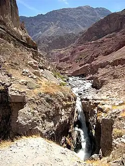
 Cascade of Sipia, Toro district | |
| Country | |
| Region | Arequipa |
| Province | La Unión |
| Founded | May 4, 1835 |
| Capital | Toro |
| Government | |
| • Mayor | Francisco Elias Tapia Martinez |
| Area | |
| • Total | 391.44 km2 (151.14 sq mi) |
| Elevation | 2,964 m (9,724 ft) |
| Population | |
| • Total | 1,205 |
| • Density | 3.1/km2 (8.0/sq mi) |
| Time zone | UTC-5 (PET) |
| UBIGEO | 040811 |
Geography
One of the highest peaks of the district is Sulimana at 6,093 m (19,990 ft). Other mountains are listed below:[2]
- Hatun Ikma
- Hatun Yaritayuq
- Huch'uy Ikma
- Huch'uy Yaritayuq
- Kimsa Urqu
- Kuntur Sinqa
- Puka Puka
- Puka Urqu
- Qaqa Wachu
- Q'illu Q'illu
- Yana Qaqa
- Yana Ranra
References
- (in Spanish) Instituto Nacional de Estadística e Informática. Banco de Información Distrital Archived 2008-04-10 at the Wayback Machine. Retrieved April 11, 2008.
- escale.minedu.gob.pe/ UGEL map La Unión Province (Arequipa Region)
This article is issued from Wikipedia. The text is licensed under Creative Commons - Attribution - Sharealike. Additional terms may apply for the media files.