Tropical Storm Elida (1996)
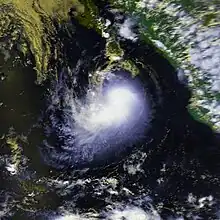
Tropical Storm Elida was a strong tropical storm that killed 6 people offshore Mexico and affected over 1,000 others. The ninth tropical cyclone of the below-average 1996 Pacific hurricane season, Elida's origins was a tropical wave that organized into Tropical Depression Eight-E on August 30. The cyclone paralleled the coast of Mexico and also gradually decelerated. Despite some wind shear, Eight-E strengthened into a tropical storm on September 2 and was named Elida. On September 3 and 4, Elida came close to the southern tip of the Baja California Peninsula at its peak intensity of 994 mbar (29.4 inHg) and winds of 65 mph (105 km/h). The cyclone then drifted into cooler waters, was devoid of deep convection on September 5, and dissipated the next day.[1]
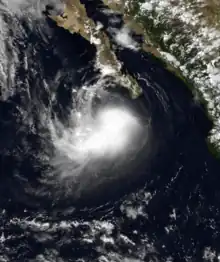
 Tropical Storm Elida off the Baja California Peninsula on September 3. | |
| Meteorological history | |
|---|---|
| Formed | August 30, 1996 |
| Dissipated | September 6, 1996 |
| Tropical storm | |
| 1-minute sustained (SSHWS/NWS) | |
| Highest winds | 65 mph (100 km/h) |
| Lowest pressure | 994 mbar (hPa); 29.35 inHg |
| Overall effects | |
| Fatalities | 6 |
| Damage | Minimal |
| Areas affected | Mexico, Baja California |
Part of the 1996 Pacific hurricane season | |
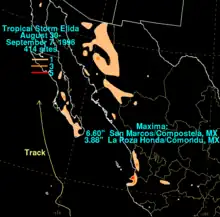
The storm was forecast slightly better than the long term averages for the eastern North Pacific.[1] Elida posed enough of a threat to the Baja California Peninsula to require a tropical storm warning for the Baja California Peninsula south of Cabo San Lázaro on September 3. The warning was lifted on September 5 after the threat ended.[1] Moderate to heavy rains fell in association with the tropical cyclone across southwest Mexico and the Baja California peninsula, with the maxima falling at San Marcos/Compostela in southwest mainland Mexico, which measured 6.60 in (168 mm), and a maximum for Baja California of 3.88 in (99 mm) at La Poza Honda/Comondu.[1] While passing offshore, the tropical storm killed six people and affected 1,200 others,[2] but the damages were minimal.[3]
Meteorological history

Tropical storm (39–73 mph, 63–118 km/h)
Category 1 (74–95 mph, 119–153 km/h)
Category 2 (96–110 mph, 154–177 km/h)
Category 3 (111–129 mph, 178–208 km/h)
Category 4 (130–156 mph, 209–251 km/h)
Category 5 (≥157 mph, ≥252 km/h)
Unknown
A tropical wave moved across the tropical Atlantic during mid to late August, developing a small area of thunderstorms each day. After it moved into the Pacific Ocean, thunderstorm activity became more concentrated on August 30 to the south of Mexico. The low soon had experienced deep convection in the system, which will lead to the storm's intensification.[4]
Intensifying into a tropical depression, Elida initially was heading course west-northwest towards the 110th meridian at 12:00 UTC.[4] Light northeasterly vertical wind shear kept Elida's development slow, but prominent wind bands and independent thunderstorms supported Elida's development further. with the system named Tropical Storm Elida on September 2. This new system was 175 miles (282 km) off the coast of Baja California.[5] Elida posed enough of a threat to the Baja California Peninsula to require a tropical storm warning and some sources state hurricane watches for the Baja California Peninsula south of Cabo San Lázaro on September 3 at 21:00 UTC.[1][6][7][5] Elida was 200 km west-southwest of the southern tip of the Baja California peninsula. and moving at 3 mph at the time.[7]
Tropical storm force winds had extended outwards out to 85 miles (140 km) from the center. The tropical storm warning for Elida was lifted on September 5 after the threat had ended.[8]
An upper low moved to the north of the system, slowing its forward movement and shifting its track more northerly in the direction of Baja California.[8] After paralleling the southern tip of the peninsula, a combination of vertical wind shear and reduced sea surface temperatures weakened the system to dissipation by the time it passed Point Eugenia on September 7.[6][9] Another factor to the dissipation was the surface circulation and the stripping of the system's deep convection.[10]

Preparations and impact

During Elida's passage, the storm killed 6 people offshore and affected more than 1,200 people. Moderate to heavy rains fell in association with the tropical cyclone across southwest Mexico and the Baja California Peninsula.[1][8]
Moderate to heavy rains fell in association with the tropical cyclone across southwest Mexico and the Baja California peninsula, with the maxima falling at San Marcos — Compostela in southwest mainland Mexico, which measured 6.60 in (168 mm), and a maximum for Baja California of 3.88 in (99 mm) at La Poza Honda — Comondu.[1][4] Baja California Sur had also underwent a tropical storm warning that day.[11] Socorro Island had been impacted by Elida as well.[8]
Ports on the Baja California coast had to close down due to Elida's 7-foot waves.[8]
While passing offshore, the tropical storm killed six people and affected 1,200 others, but the damages were minimal.[2] Elida had tropical storm warnings until September 5 when Elida was degraded to a tropical depression. Elida dissipated after passing by Point Eugenia on September 7.[6]
References
- Rappaport, Edward (July 11, 1996). "Tropical Storm Elida Preliminary Report" (PDF). National Hurricane Center. Retrieved February 23, 2007.
- "Hurricane Marty". www.emdat.be/. Centre for Research on the Epidemiology of Disasters. March 18, 2021. Archived from the original on September 23, 2010. Retrieved March 18, 2021.
- Climate Monitor. Climatic Research Unit, School of Environmental Sciences, University of East Anglia. 1997.
- Kimberlain, Todd B.; Brennan, Michael J. (2011-06-01). "Eastern North Pacific Hurricane Season of 2009". Monthly Weather Review. 139 (6): 1657–1672. Bibcode:2011MWRv..139.1657K. doi:10.1175/2010mwr3497.1. ISSN 0027-0644.
- Longshore, David (2008). Encyclopedia of Hurricanes, Typhoons, and Cyclones. Infobase Publishing. ISBN 978-1-4381-1879-6.
- Contemporary; Books, Contemporary (September 1990). Chase's Annual Events: Special Days, Weeks and Months in 1991. McGraw-Hill. ISBN 978-0-8092-4087-6.
- "TROPICAL STORM ELIDA INTERMEDIATE ADVISORY NUMBER 10A". NOAA. September 3, 1996. Retrieved March 18, 2021.
- Mariners Weather Log. U.S. Department of Commerce, National Oceanic and Atmospheric Administration, Environmental Data and Information Service. 1996.
- Monthly Weather Review. Springfield, Illinois: War Department, Office of the Chief Signal Officer. August 28, 2000. p. 3704.
- Mayfield, Max; Rappaport, Edward N. (December 1, 1998). "Eastern North Pacific Hurricane Season of 1996". Monthly Weather Review. 126 (12): 3068–3076. Bibcode:1998MWRv..126.3068M. doi:10.1175/1520-0493(1998)126<3068:ENPHSO>2.0.CO;2. ISSN 1520-0493. S2CID 123135673.
- "TROPICAL STORM ELIDA FORECAST/ADVISORY NUMBER 10". NOAA. September 4, 1996. Retrieved March 18, 2021.
