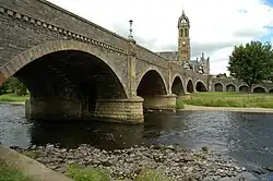
Tweed Bridge
The Tweed Bridge is a stone-built road bridge of five spans over the River Tweed in Peebles, in the Scottish Borders.
Tweed Bridge | |
|---|---|
 | |
| Coordinates | 55.650331°N 3.192665°W |
| Carries | B7062 public road |
| Crosses | River Tweed |
| Characteristics | |
| Material | Stone |
| Width | 40 feet (12 m) |
| No. of spans | 5 |
| History | |
| Construction end | 15th century |
| Location | |
History

The Tweed Bridge is medieval in origin, although the exact date of its construction is unknown.[1] Records show that a stone bridge has been maintained at the site since the middle of the 15th century, and work done in 1465 may have been the construction of a new bridge or substantial rebuilding or maintenance of an existing one.[2][1][3] A mason known as John of Peebles may have worked on the bridge at that time.[1] A plaque on the bridge states that it was originally a wooden bridge clad in stone.[4]
It was reconstructed in 1663 using stone from St Andrew's Church which had been destroyed in 1548 by an English army as part of the Rough Wooing.[2] John Hisplop added three additional arches to the south end of the bridge in 1799, but these were removed when the Peebles Railway was built.[1]
The bridge was widened from 8 feet (2.4 m) to 21 feet (6.4 m) in 1834 by adding stonework to both sides.[5][6] This work was done by John and Thomas Smith of Darnick, and the cost of around £1,000 was funded by public subscription.[5] Between 1897 and 1900, it was widened again to 40 feet (12 m) by adding to the downstream side.[5] This work, which cost about £8,000, was done by McTaggart, Cowan and Barker, and funded by the Town Council.[5]
On the south side of the bridge the remains of Second World War defences were evident until the road was resurfaced.[7]
The bridge was listed as a category A listed building in 1971.[5] Plans are being considered for an additional bridge over the Tweed in the town.[8][9]
Design

The five spans vary in length from 38 feet (12 m) to 42 feet (13 m).[1] The oldest part of the bridge uses arches which are almost circular, but the more modern parts use flatter segmental arches.[1] On the upstream side the piers have triangular ashlar cutwaters, and rounded profiles on the downstream side.[2][5] At the north end of the bridge is an arched ramp to the east that leads to Tweed Green.[5][10]
The Tweed Bridge is the only road crossing of the Tweed within Peebles.[2] It carries the B7062 public road, which is two lanes wide at this point.[10] Near to the Tweed Bridge is the Cuddy Bridge, a single arch bridge over the Eddleston Water, a tributary of the Tweed.[11]
References
- "Peebles, Tweed Bridge". rcahms.gov.uk. Retrieved 19 March 2015.
- "Tweed Bridge, Peebles". engineering-timelines.com. Retrieved 19 March 2015.
- Renwick, Robert (1903). Peebles: Burgh and Parish in Early History. A. Redpath. p. 61.
- Tweed Bridge (15th century). Plaque on bridge.
- Historic Environment Scotland. "Tweed Bridge (Category A Listed Building) (LB39278)". Retrieved 29 March 2019.
- Chambers, William (1856). Peebles and its Neighbourhood, with a Run on Peebles Railway. p. 44.
- "Peebles, Tweed Bridge (Peebles Defences)". rcahms.gov.uk. Retrieved 19 March 2015.
- "Peebles new River Tweed road bridge options examined". BBC News. 9 November 2012. Retrieved 19 March 2015.
- "Progress made on new Tweed Bridge". Peeblesshire News. 5 May 2013. Retrieved 19 March 2015.
- Google (19 March 2015). "Tweed Bridge" (Map). Google Maps. Google. Retrieved 19 March 2015.
- "Peebles, Cuddy Bridge". rcahms.gov.uk. Retrieved 19 March 2015.