Twin Lakes, Lake County, Colorado
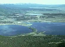
Twin Lakes is a pair of glacier-carved alpine lakes about 15 miles (24 km) south of historic Leadville, Colorado. They are downstream along the Arkansas River, whose headwaters are by Leadville. The lakes, however, are on a tributary, Lake Creek, which joins the Arkansas just below the lakes. After dredging, the lakes now have a surface area of 2,700 acres (11 km2), and they serve as a reservoir to store water for use in the Front Range. Both east and west lakes are recreation areas for boating and fishing.[5]
Twin Lakes, Lake County, Colorado | |
|---|---|
 Mount Hope from Twin Lakes. | |
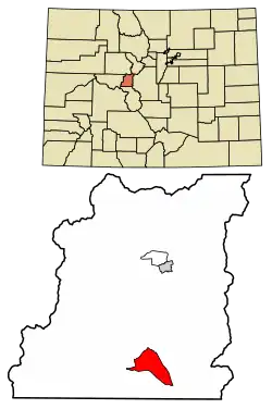 Location of the Twin Lakes CDP in Lake County, Colorado. | |
 Twin Lakes Location of the Twin Lakes CDP in the United States. | |
| Coordinates: 39°05′07″N 106°21′19″W[1] | |
| Country | |
| State | |
| County | Lake County |
| Government | |
| • Type | unincorporated town |
| Area | |
| • Total | 1.661 sq mi (4.302 km2) |
| • Land | 1.644 sq mi (4.258 km2) |
| • Water | 0.017 sq mi (0.044 km2) |
| Elevation | 9,603 ft (2,927 m) |
| Population | |
| • Total | 204 |
| • Density | 120/sq mi (47/km2) |
| Time zone | UTC-7 (MST) |
| • Summer (DST) | UTC-6 (MDT) |
| ZIP Code[4] | 81251 |
| Area code | 719 |
| GNIS feature[2] | Twin Lakes CDP |
Twin Lakes is also the name of an adjacent census-designated place (CDP) and a post office in and governed by Lake County, Colorado, United States. The Twin Lakes post office has the ZIP Code 81251.[4] At the United States Census 2020, the population of the Twin Lakes CDP was 204.[3]
History
.jpg.webp)
Lake County, one of the original 17 counties created by the Colorado legislature in 1861, was named for the Twin Lakes. As originally defined, Lake County included a large portion of western Colorado to the south and west of its present boundaries. The Twin Lakes District has been listed on the National Register of Historic Places since 1974.
Geography
The Twin Lakes and the Twin Lakes CDP are located about 15 miles (24 km) south of Leadville, the county seat. The CDP is bounded on the east by U.S. Route 24 (US 24), on the south by Colorado State Highway 82 (SH 82, and on the north and west by County Highway 24. About 4 miles (6 km) west of the CDP is the original community of Twin Lakes, near the west end of what is now the Twin Lakes Reservoir. The reservoir lies south of SH 82, outside the CDP. SH 82 leads west across Independence Pass 40 miles (64 km) to Aspen, while US 24 leads north to Leadville and south 20 miles (32 km) to Buena Vista.
The altitude of the Twin Lakes area ranges from 9,200 feet (2,800 m) to over 9,800 feet (3,000 m), all of it somewhat lower than Leadville. Mount Elbert, the highest peak in Colorado, rises directly west of the CDP to its 14,433-foot (4,399 m) summit, just 6 miles (10 km) west of the center of the CDP.
The Twin Lakes CDP has an area of 1,063 acres (4.302 km2), including 11 acres (0.044 km2) of water,[1] (much less than the surface area of the Twin Lakes themselves).
Demographics
| Year | Pop. | ±% |
|---|---|---|
| 2010 | 171 | — |
| 2020 | 204 | +19.3% |
| Source: United States Census Bureau | ||
The United States Census Bureau initially defined the Twin Lakes CDP for the United States Census 2010.
References
- "State of Colorado Census Designated Places - BAS20 - Data as of January 1, 2020". United States Census Bureau. Retrieved December 22, 2020.
- "U.S. Board on Geographic Names: Domestic Names". United States Geological Survey. Retrieved December 22, 2020.
- United States Census Bureau. "Twin Lakes CDP (Lake County), Colorado". Retrieved April 15, 2023.
- "Look Up a ZIP Code". United States Postal Service. Retrieved December 22, 2020.
- https://www.uncovercolorado.com/towns/twin-lakes/
External links
- Twin Lakes @ Colorado.com
- Twin Lakes @ Leadville.com
- Twin Lakes @ LeadvilleTwinLakes.com
- Twin Lakes @ TwinLakesCo.com
- Twin Lakes @ UncoverColorado.com
- Twin Lakes @ VisitTwinLakes.com
- Friends of Twin Lakes
- Twin Lakes Recreation Area
- Mount Elbert Pumped Hydroelectric Powerplant
- Lake County website
Municipalities and communities of Lake County, Colorado, United States | ||
|---|---|---|
| City | 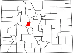 Map of Colorado highlighting Lake County | |
| CDPs | ||
| Ghost and former towns | ||