Typhoon Kent (1992)
Typhoon Kent was a strong mid-season typhoon that struck southern Japan during August 1992. An area of convection developed east of the International Date Line. Tracking west-northwestward, a tropical depression developed on August 5, and the next day, intensified into a tropical storm. On August 8, increased vertical wind shear caused convection to decrease, although Kent strengthened into a typhoon on the next day. An eye then appeared as conditions aloft became more conducive, and on August 11, Kent attained its peak intensity. Under the influence of a subtropical ridge located to its north, the typhoon initially continued to move west-northwestward before turning towards Kyushu. The storm steadily weakened prior to making landfall on August 18 just below typhoon intensity. The mountainous terrain of Japan accelerated the weakening trend, and on August 20, Kent dissipated.
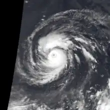
 Typhoon Kent at peak intensity on August 11 | |
| Meteorological history | |
|---|---|
| Formed | August 6, 1992 |
| Dissipated | August 19, 1992 |
| Very strong typhoon | |
| 10-minute sustained (JMA) | |
| Highest winds | 175 km/h (110 mph) |
| Lowest pressure | 930 hPa (mbar); 27.46 inHg |
| Category 4-equivalent super typhoon | |
| 1-minute sustained (SSHWS/JTWC) | |
| Highest winds | 240 km/h (150 mph) |
| Overall effects | |
| Fatalities | 8 total |
| Injuries | 2 |
| Damage | $15 million (1992 USD) |
| Areas affected | Japan |
| IBTrACS | |
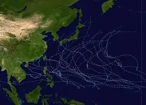
Part of the 1992 Pacific typhoon season | |
The cyclone was the third to hit Japan during August 1992, the second highest number of storms to hit Japan in a month. The typhoon dropped heavy rainfall across western portions of the Japanese archipelago, peaking at 1,286 mm (50.6 in) in Hidegadake. Nationwide, eight fatalities were reported and two others sustained injuries. Rough seas in Tokushima Prefecture swept away five of six family members, with the sixth severely wounded. Another individual drowned in Kyoto Prefecture and a swimmer was injured offshore Tottori Prefecture. A total of 1,561 houses were destroyed while 379 others were flooded. Furthermore, two vessels were damaged. Many ferries linking Honshu and Kyushu were cancelled. Monetary damage totaled ¥1.9 billion (US$15 million). [nb 1][nb 2]
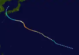
Meteorological history

Tropical storm (39–73 mph, 63–118 km/h)
Category 1 (74–95 mph, 119–153 km/h)
Category 2 (96–110 mph, 154–177 km/h)
Category 3 (111–129 mph, 178–208 km/h)
Category 4 (130–156 mph, 209–251 km/h)
Category 5 (≥157 mph, ≥252 km/h)
Unknown
As Typhoon Janis, the previous storm, intensified south of Guam, the tropical disturbance that later became Typhoon Kent developed east of the International Date Line. Its persistent convection prompted the Joint Typhoon Warning Center (JTWC) to start following the system at 06:00 UTC on August 3.[1] Forty-eight hours later, the Japan Meteorological Agency (JMA) classified the system as a tropical depression.[2][nb 3][nb 4] An increase in the amount and organization of the disturbance's deep convection prompted the JTWC to issue a Tropical Cyclone Formation Alert at 15:00 UTC on August 5. The system began to a mature at a faster clip[1] as it tracked west-northwest.[5] The JTWC started issuing warnings three hours later, and at 00:00 UTC on August 6, the JTWC upgraded the depression into a tropical storm,[1] with the JMA doing the same at 06:00 UTC.[6] Eighteen hours later, the JTWC upgraded Kent to a typhoon,[7] with the JMA declaring it a severe tropical storm.[2]
After becoming a severe tropical storm, the rate of intensification slowed. On August 8, increased vertical wind shear associated with the passage of a mid-level trough to the north resulted in a reduction in the thickness of Kent's central dense overcast. Even though intensification was arrested[1] (the JTWC and JMA estimated that the storm maintained winds of 160 km/h (100 mph) and 120 km/h (75 mph) for 30 and 42 hours respectively),[6] a small core of persistent central convection remained. As the trough passed by, the re-appearance of an eye indicated that steady intensification had resumed. At noon on August 11, Kent was upgraded into a super typhoon by the JTWC.[1] At the same time, the JTWC and JMA estimated that the typhoon attained its peak intensity of 240 km/h (150 mph) and 175 km/h (110 mph), with a minimum barometric pressure of 930 mbar (27 inHg).[6]
Under the influence of a subtropical ridge located to its north, the typhoon maintained its intensity as it continued to move west-northwestward until a shortwave trough moved across Honshu on August 13. Kent subsequently slowed down and turned towards the north in response to the weakness in the subtropical ridge. Then, the trough passed by and the typhoon, which was by this time weakening due to increased wind shear, veered towards Honshu. On August 16, Kent began to interact with Tropical Storm Lois, which had formed two days earlier. As a consequence, Kent turned towards Kyushu.[1] Later on August 16, the JMA and JTWC estimated that Kent lost typhoon intensity. At 00:00 UTC on August 18, Kent moved ashore over Kyushu, with the JTWC and JMA reporting winds of 115 km/h (70 mph) and 105 km/h (65 mph).[6] Shortly thereafter the interaction between the tropical cyclones had ceased, and Kent was approaching recurvature. After landfall, interaction with the mountainous terrain of Kyushu, along with increased wind shear aloft, quickly weakened Kent. At midday on August 19, Kent was downgraded to a tropical depression by the JTWC after the center had become exposed from the deep convection.[1] Both the JTWC and JMA ceased tracking Kent on August 20.[6]
Impact
| Precipitation | Storm | Location | Ref. | ||
|---|---|---|---|---|---|
| Rank | mm | in | |||
| 1 | 2781.0 | 109.50 | Fran 1976 | Hiso | [8] |
| 2 | >2000.0 | >78.74 | Namtheun 2004 | Kisawa | [9] |
| 3 | 1805.5 | 71.08 | Talas 2011 | Kamikitayama | [10] |
| 4 | 1518.9 | 59.80 | Olive 1971 | Ebino | [11] |
| 5 | 1322.0 | 52.04 | Nabi 2005 | Mikado | [12] |
| 6 | 1286.0 | 50.62 | Kent 1992 | Hidegadake | [13] |
| 7 | 1167.0 | 45.94 | Judy 1989 | Hidegadake | [14] |
| 8 | 1138.0 | 44.80 | Abby 1983 | Amagisan | [15] |
| 9 | 1124.0 | 44.25 | Flo 1990 | Yanase | [16] |
| 10 | ~1092.0 | ~43.00 | Trix 1971 | Yangitake | [17] |
Typhoon Kent was the third tropical cyclone to hit Japan during August 1992,[18] following Tropical Storm Irving[19] and Typhoon Janis.[20] This was the second highest number of storms to hit Japan in a month.[18] The typhoon dropped heavy rainfall across western portions of the Japanese archipelago.[21] A peak rainfall total of 1,286 mm (50.6 in) occurred at Hidegadake.[22] A peak hourly rainfall total of 64 mm (2.5 in) was observed in Mount Amagi.[23] Meanwhile, a peak daily precipitation total of 633 mm (24.9 in) fell in Hidegdake.[22] A wind gust of 94 km/h (58 mph) was recorded in the city of Tosashimizu.[24] Nationwide, eight fatalities were reported and two others sustained injuries. A total of 1,561 houses were destroyed while 379 others were flooded.[21] Moreover, two vessels were damaged.[21] Many ferries linking Honshu and Kyushu were cancelled.[25] Monetary damage totaled ¥1.9 billion (US$15 million).[21]
Rough seas in Tokushima Prefecture swept away a family of six from the seaside[26] with five dead[27] and one seriously wounded,[26] while in a separate incident, one person perished. Thirty-six houses were damaged in the prefecture and damage was estimated at ¥810 million.[28] In Miyazaki Prefecture, all flights and trains were canceled. Around 300 homes lost power.[25] A total of 143 homes were damaged and 168 homes were destroyed, which resulted in 931 people homeless in Kōchi Prefecture.[29] Roads were damaged in 118 locations in Ehime Prefecture.[30] Some flights were called off at Kagoshima Airport,[25] where damage was estimated at ¥245 million. Over 400 m (1,310 ft) of beaches there were eroded.[31] A swimmer was in critical condition in Tottori Prefecture due to high waves.[26] Thirty-three ferries were canceled in Wakayama Prefecture.[32] Thirty homes were damaged in Hyōgo Prefecture.[33] Damage in Okayama Prefecture amounted to ¥297 million.[34] Power lines were damaged in 606 locations in Hiroshima Prefecture and damage was at ¥358 million.[35] Another person drowned in Kyoto Prefecture.[26] Twelve flights were cancelled in Shimane Prefecture.[36]
See also
- Other tropical cyclones named Kent
- Typhoon Kinna (1991) - similar mid-season Japan-hitting Japan
Notes
- All currencies are converted from Japanese yen to United States Dollars using this with an exchange rate of the year 1992.
- All damage totals are in 1992 values of their respective currencies.
- The Japan Meteorological Agency is the official Regional Specialized Meteorological Center for the western Pacific Ocean.[3]
- Wind estimates from the JMA and most other basins throughout the world are sustained over 10 minutes, while estimates from the United States-based Joint Typhoon Warning Center are sustained over 1 minute. 10-minute winds are about 1.14 times the amount of 1-minute winds.[4]
References
- Joint Typhoon Warning Center; Naval Pacific Meteorology and Oceanography Center (1993). Annual Tropical Cyclone Report: 1992 (PDF) (Report). United States Navy, United States Air Force. Retrieved August 10, 2017.
- Japan Meteorological Agency (October 10, 1992). RSMC Best Track Data – 1990–1999 (.TXT) (Report). Retrieved August 10, 2017.
- "Annual Report on Activities of the RSMC Tokyo – Typhoon Center 2000" (PDF). Japan Meteorological Agency. February 2001. p. 3. Retrieved August 10, 2017.
- Christopher W Landsea; Hurricane Research Division (April 26, 2004). "Subject: D4) What does "maximum sustained wind" mean? How does it relate to gusts in tropical cyclones?". Frequently Asked Questions. National Oceanic and Atmospheric Administration's Atlantic Oceanographic and Meteorological Laboratory. Retrieved August 10, 2017.
- Hong Kong Observatory (1993). "Part III – Tropical Cyclone Summaries". Meteorological Results: 1992 (PDF). Meteorological Results (Report). Hong Kong Observatory. p. 14. Retrieved August 10, 2017.
- Kenneth R. Knapp; Michael C. Kruk; David H. Levinson; Howard J. Diamond; Charles J. Neumann (2010). 1992 KENT (1992216N06182). The International Best Track Archive for Climate Stewardship (IBTrACS): Unifying tropical cyclone best track data (Report). Bulletin of the American Meteorological Society. Retrieved August 8, 2017.
- Typhoon 11W Best Track (TXT) (Report). Joint Typhoon Warning Center. December 17, 2002. Retrieved August 10, 2017.
- Ikuo Tasaka (1981). "The Difference of Rainfall Distribution in Relation to Time-Scale: A Case Study on Heavy Rainfall of September 8–13, 1976, in the Shikoku Island Caused by Typhoon 7617 Fran" (PDF). Geographical Review of Japan (in Japanese). 54 (10): 570–578. doi:10.4157/grj.54.570. Retrieved January 5, 2016.
- Gonghui Wang; Akira Suemine; Gen Furuya; Masahiro Kaibori & Kyoji Sassa (2006). Rainstorm-induced landslides in Kisawa village, Tokushima Prefecture, Japan (PDF) (Report). International Association for Engineering Geology. Retrieved January 5, 2016.
- "Typhoon Talas". Japan Meteorological Agency. 2011. Retrieved September 6, 2011.
- "Typhoons of the Western North Pacific, 1971". Climatological Data: National Summary. National Oceanic and Atmospheric Administration. 22 (1): 771. January 1971. Retrieved April 12, 2013.
- "台風200514号 (Nabi) - 災害情報" (in Japanese). National Institute of Informatics. 2011. Retrieved December 31, 2011.
- "台風199211号 (Kent) - 災害情報" (in Japanese). National Institute of Informatics. 2011. Retrieved December 31, 2011.
- "アメダス日出岳(64211)@台風198911号" (in Japanese). National Institute of Informatics. 2011. Retrieved December 31, 2011.
- "台風198305号 (Abby) - 災害情報" (in Japanese). National Institute of Informatics. 2011. Retrieved December 31, 2011.
- "台風199019号 (Flo) - 災害情報" (in Japanese). National Institute of Informatics. 2011. Retrieved December 31, 2011.
- "Annual Tropical Cyclone Report: Typhoon Trix" (PDF). Joint Typhoon Warning Center. United States Navy. 1972. pp. 183–192. Retrieved April 12, 2013.
- "Typhoon No. 11 Moving North Over Japan Sea". Japanese Economic Newswire. August 19, 1992. – via Lexis Nexis (subscription required)
- Asanobu, Kitamoto. Typhoon 199209 (Irving). Digital Typhoon (Report). National Institute of Informatics. Retrieved August 11, 2017.
- Asanobu, Kitamoto. Typhoon 199210 (Janis). Digital Typhoon (Report). National Institute of Informatics. Retrieved August 11, 2017.
- Asanobu, Kitamoto. Typhoon 199211 (Kent). Digital Typhoon (Report). National Institute of Informatics. Retrieved August 11, 2017.
- Asanobu, Kitamoto. AMeDAS HIDEGADAKE (64211) @ Typhoon 199211. Digital Typhoon (Report). National Institute of Informatics. Retrieved August 11, 2017.
- Asanobu, Kitamoto. AMeDAS AMAGISAN (50427) @ Typhoon 199211. Digital Typhoon (Report). National Institute of Informatics. Retrieved August 11, 2017.
- Asanobu, Kitamoto. AMeDAS MUROTOMISAKI (74371) @ Typhoon 199211. Digital Typhoon (Report). National Institute of Informatics. Retrieved August 11, 2017.
- "Typhoon to Hit Kyushu, Western Japan Tuesday Afternoon". Japanese Economic Newswire. August 18, 1992.
- "Typhoon No. 11 Blamed for Four Deaths". Japanese Economic Newswire. August 17, 1992. – via Lexis Nexis (subscription required)
- "High Waves Kill 3 With 2 Others Missing in Western Japan". Japanese Economic Newswire. August 17, 1992. – via Lexis Nexis (subscription required)
- Asanobu, Kitamoto. 1992-895-04. Digital Typhoon (Report). National Institute of Informatics. Retrieved August 11, 2017.
- Asanobu, Kitamoto. 1992-893-10. Digital Typhoon (Report). National Institute of Informatics. Retrieved August 11, 2017.
- Asanobu, Kitamoto. 1992-887-10. Digital Typhoon (Report). National Institute of Informatics. Retrieved August 11, 2017.
- Asanobu, Kitamoto. 1992-827-19. Digital Typhoon (Report). National Institute of Informatics. Retrieved August 11, 2017.
- Asanobu, Kitamoto. 1992-777-09. Digital Typhoon (Report). National Institute of Informatics. Retrieved August 11, 2017.
- Asanobu, Kitamoto. 1992-770-06. Digital Typhoon (Report). National Institute of Informatics. Retrieved August 11, 2017.
- Asanobu, Kitamoto. 1992-768-07. Digital Typhoon (Report). National Institute of Informatics. Retrieved August 11, 2017.
- Asanobu, Kitamoto. 1992-765-06. Digital Typhoon (Report). National Institute of Informatics. Retrieved August 11, 2017.
- Asanobu, Kitamoto. 1992-741-04. Digital Typhoon (Report). National Institute of Informatics. Retrieved August 11, 2017.
