U.S. Route 78
U.S. Route 78 (US 78) is an east–west United States Numbered Highway that runs for 715 miles (1,151 km) from Memphis, Tennessee, to Charleston, South Carolina. From Byhalia, Mississippi to Birmingham, Alabama, US 78 runs concurrently with Interstate 22 (I-22). The highway's western terminus is at US 64/US 70/US 79 (Second Street) in Memphis, and its eastern terminus is on Line Street, in Charleston.
U.S. Route 78 | ||||||||||||||||
|---|---|---|---|---|---|---|---|---|---|---|---|---|---|---|---|---|
US 78 highlighted in red | ||||||||||||||||
| Route information | ||||||||||||||||
| Length | 715 mi (1,151 km) | |||||||||||||||
| Existed | 1926–present | |||||||||||||||
| Major junctions | ||||||||||||||||
| West end | ||||||||||||||||
| ||||||||||||||||
| East end | Line Street at Charleston, SC | |||||||||||||||
| Location | ||||||||||||||||
| Country | United States | |||||||||||||||
| States | Tennessee, Mississippi, Alabama, Georgia, South Carolina | |||||||||||||||
| Highway system | ||||||||||||||||
| ||||||||||||||||

Route description
| mi | km | |
|---|---|---|
| TN | 14.7 | 23.7 |
| MS | 118.0 | 189.9 |
| AL | 194.0 | 312.2 |
| GA | 233.3 | 375.5 |
| SC | 142.2 | 228.8 |
| Total | 702.9 | 1,131.2 |
Tennessee
US 78 runs along Linden Avenue, Somerville Street, E. H. Crump Boulevard, and Lamar Avenue through Memphis, Tennessee. In Tennessee, US 78 is historically known as Pigeon Roost Road, and some aborted sections of the highway in Mississippi also claim that name as well as Lamar Avenue. Throughout the Tennessee portion, US 78 is overlapped in its entirety by State Route 278 (SR 278), along Linden Avenue and Somerville Street, and State Route 4 (SR 4) along E. H. Crump Boulevard and Lamar Avenue.[1]
Mississippi
US 78 is a freeway for its entire length in Mississippi. The section from its intersection with Interstate 269 in Byhalia, Mississippi to the Alabama state line is concurrent with Interstate 22. The highway runs across the northeastern rural part of the state, connecting several population centers. Mississippi's portion of US 78 is defined in Mississippi Code Annotated § 65-3-3. The old routing of US 78 through the state is signed as MS 178.
Alabama
US 78 is a major east–west U.S. highway across the central part of Alabama. It is internally designated State Route 4 (SR 4) by the Alabama Department of Transportation, though the only section of State Route 4 that is signed is along portions mainly west of Jasper. The section from the Mississippi state line to near Graysville is concurrent with Interstate 22; from Graysville south to Birmingham, US 78 takes its original routing. East of Birmingham to the Georgia state line, US 78 has been replaced as a major through-route by Interstate 20. The two routes roughly parallel each other, with junctions at Leeds and Pell City.[2]
West of Jasper, old US 78 is signed as AL 118 to Guin, and the segment from Guin northward to I-22 at Hamilton is signed as US 43/US 278.
Georgia
US 78 enters Georgia in Haralson County, and then proceeds through Carroll County and Douglas County. In Douglasville, located in Douglas County, US 78 runs through the downtown, historical part of the city. It is the original thoroughfare for these Georgia counties.
The route then continues eastward through Cobb and Fulton counties into Atlanta. After crossing Peachtree Street, where US 78 marks a boundary between downtown and Midtown, US 78 is largely conterminous with Ponce de Leon Avenue. As it proceeds due east, this section of the route passes Ponce City Market and crosses the Eastside Trail of the BeltLine before skirting a number of Frederick Law Olmsted-designed parks in the Druid Hills Historic District at the eastern edge of the city.
After entering Decatur in DeKalb County, US 78 departs from Ponce de Leon Avenue to head northeast. South of the site of North DeKalb Mall, another short freeway portion begins — leading from just inside the eastern rim of Interstate 285 (the Perimeter) to the suburbs of Clarkston, Tucker, Stone Mountain, and Snellville. This portion is named the Stone Mountain Freeway, and provides an excellent view of Stone Mountain for eastbound motorists.
The route then proceeds east across Gwinnett, Walton, and Oconee counties. In Oconee County, US 78 leaves Moina Michael Highway at the SR 316 interchange, turning right and running concurrent with SR 316/US 29. (From this point, Moina Michael Highway is signed as US 78 Business, which follows the original route of US 78 through Athens, Ga.) At the terminal eastern interchange of SR 316 both US 78 and US 29 turn right and join with SR 10 Loop, a mostly interstate-grade bypass that rings Athens-Clarke County. US 78 exits the bypass and turns right at the Lexington Road interchange. From there US 78 passes through Oglethorpe, Wilkes, McDuffie and Columbia Counties into Augusta and then onto one of the twin bridges across the Savannah River into South Carolina.[3]
South Carolina
US 78 provides the most direct route between Augusta and Charleston, through the South Carolina Lowcountry. Crossing Savannah River into the state, it goes northeast into Aiken before going southeasterly through the cities and towns of Williston, Blackville, Denmark, Bamberg, Branchville, and St. George. East of Dorchester, it parallels Interstate 26 into downtown Charleston, where it ends.[4]
History
In western Alabama, the historical name of US 78 is Bankhead Highway. It is also known by this name in portions of Georgia, including Atlanta, and the Bankhead neighborhood takes its name from that stretch of road. Also, the old section of US 78 (now MS 178) that travels through downtown New Albany, Mississippi, is named Bankhead Street.
Throughout the 2000s, US 78 has been gradually upgraded into a four-lane freeway in Mississippi and Alabama and signed as I-22. US 78 is concurrent with I-22 from Byhalia, Mississippi to just outside of Birmingham, Alabama, only branching off just outside of Graysville, Alabama with I-22 traveling about 11 miles (18 km) eastward to its terminus at I-65.[5]
Future
US 78 and SR 4 in Memphis, Tennessee is currently being upgraded between the Mississippi state line and SR 176, a distance of about 5.1 miles (8.2 km). The route, Lamar Avenue, sees heavy freight traffic and has "crippling congestion." The work includes expanding the road from four to six lanes, adding three new interchanges, and upgrading additional ones. The work is being done in three segments with the first one starting in 2018.[6]
On October 25, 2023, the Arkansas Highway Commission voted unanimously to extend the US 78 designation into Northeast Arkansas. According to the Arkansas Department of Transportation (ARDOT), the US 78 designation will be extended along several other routes from its current its western terminus in Memphis, Tennessee across the Memphis & Arkansas Bridge to a new western terminus near Cash, Arkansas at US 67 (Future I-57). The route will be cosigned along portions of US 64, US 70, US 79, I-55, US 61, I-40, Arkansas Highway 18 (AR 18), AR 18S, I-555, US 49, US 63, and AR 226. This extension of the US 78 route designation is seen as a way to boost economic growth in the region by assigning a single route number for travelers to follow.[7][8]
Major intersections
- Tennessee


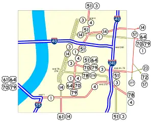
 US 64 / US 70 / US 79 in Memphis
 I-240 in Memphis
 US 51 in Memphis
- I-240 in Memphis
- Mississippi

 I-22 / I-269 west-northwest of Byhalia. Begin I-22 Concurrency.
 US 45 in Tupelo
- Alabama

 US 43 / US 278 in Hamilton
.svg.png.webp)
 Future I-222 / Future I-422 near Adamsville
Future I-222 / Future I-422 near Adamsville I-22 / I-65 near Birmingham. End I-22 Concurrency.
 I-20 / I-59 in Birmingham
 US 11 in Birmingham. The highways travel concurrently through Birmingham.
 US 31 / US 280 in Birmingham
- I-20 in Leeds
 US 411 in Leeds
- I-20 northwest of Chulavista. The highways travel concurrently to Pell City.
 US 231 in Pell City
- I-20 in Riverside
 US 431 in Oxford.
- Georgia
 US 27 in Bremen
- US 278 in Lithia Springs. The highways travel concurrently to Druid Hills.
 I-285 in Atlanta
 US 19 / US 41 in Atlanta. The highways travel concurrently through Atlanta.
 US 19 / US 29 / US 41 in Atlanta. US 29/US 78 travels concurrently to the Scottdale–North Decatur city line.
 US 23 in Atlanta. The highways travel concurrently to Decatur.
- I-285 on the Scottdale–Clarkston city line
- US 29 southeast of Bogart. The highways travel concurrently to Athens.

 US 129 / US 441 in Athens. The highways travel concurrently through Athens.
 US 378 in Washington
- I-20 north of Thomson
- US 278 southeast of Thomson. The highways travel concurrently to Clearwater, South Carolina.
 US 221 in Harlem
 I-520 in Augusta
 US 1 in Augusta. The highways travel concurrently to Aiken, South Carolina.
 US 25 in Augusta. The highways travel concurrently to North Augusta, South Carolina.
- South Carolina
- I-520 in North Augusta
 US 321 in Denmark
 US 301 / US 601 in Bamberg
 US 21 in Branchville. The highways travel concurrently through Branchville.
 I-95 in St. George
 US 15 in St. George
 US 178 east of Dorchester
 I-26 in North Charleston
 US 52 in North Charleston. The highways travel concurrently through North Charleston.
- I-26 in North Charleston
 I-526 in North Charleston
- King Street/Line Street in Charleston
See also
Related U.S. Routes
References
- Google (April 11, 2014). "Route of US-78 in Tennessee" (Map). Google Maps. Google. Retrieved April 11, 2014.
- Google (April 11, 2014). "Route of US 78 in Alabama" (Map). Google Maps. Google. Retrieved April 11, 2014.
- Google (April 11, 2014). "Route of US 78 in Georgia" (Map). Google Maps. Google. Retrieved April 11, 2014.
- Google (April 11, 2014). "Route of US 78 in South Carolina" (Map). Google Maps. Google. Retrieved April 11, 2014.
- "Interstate 22". Interstate-Guide.com. Retrieved March 18, 2023.
- "Lamar Avenue". www.tn.gov. Retrieved 20 March 2023.
- "Commission approves Highway 78 designation through Northeast Arkansas". https://www.kait8.com. 25 October 2023. Retrieved 26 October 2023.
{{cite news}}: External link in|work= - Holt, Tony (26 October 2023). "Commission approves extending U.S. 78 designation into Arkansas". Arkansas Online. Retrieved 26 October 2023.
- Rand McNally (2014). The Road Atlas (Walmart ed.). Chicago: Rand McNally. pp. 4, 28, 56, 92, 94. ISBN 978-0-528-00771-2.
External links
- Evermore Community Improvement District
- High Priority Corridors @ aaroads.com Archived 2016-03-26 at the Wayback Machine
- Highway 78 CID
- Highway 78 on OpenStreetMap.org
- Endpoints of U.S. Highway 78
Routes in italics are no longer a part of the system. Highlighted routes are considered main routes of the system. |