Umzingwane District
Umzingwane is a district in the northern part of Matabeleland South province in Zimbabwe. It was formerly known as Esigodini and before 1982 as Essexvale.[4]
Umzingwane District
Essexvale District | |
|---|---|
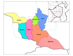 Umzingwane District in Matabeleland South | |
| Coordinates: 20°20′49″S 28°56′59″E | |
| Country | Zimbabwe |
| Province | Matabeleland South |
| Area | |
| • Total | 2,797 km2 (1,080 sq mi) |
| Elevation | 1,176 m (3,858 ft) |
| Population (2012)[3] | |
| • Total | 62,990 |
| Time zone | UTC+2 (CAT) |
Its governing seat is located in the village of Umzingwane.
Geography
Umzingwane District is located in south-east of Bulawayo City, the second biggest town of the Republic of Zimbabwe. Located in the province of Matabeleland South with its main administrative council offices are situated at Esigodini under the administrative municipality council which is Gwanda municipality. UMzingwane district is neighboured to following district which are Insiza, Matopo, Gwanda and uMguza.
Places in Umzingwane
- Bezha, a village, birthplace of Professor Thomas Dube, academic and lawyer who served as senior legal and political affairs advisor for 19 years at United Nations Security Council.
- Bonjeni, a village
- Bushtick, a village
- Bushtick Mine
- Esibomvu, a village
- Esigodini, administrative centre
- Esiphezini, birthplace of Canaan Banana, first president of Zimbabwe[4]
- Doyana, a village
- Inyankuni reservoir
- Kumbuzi, a village
- Lake Cunningham Recreational Park, 41.72 km2[5]
- Matendele, a village
- Mawabeni, a village
- Mbizingwe, a village
- Mzingwane Dam reservoir
- Mzingwane River (Umzingwane River)
- Nsezi, a village.Home of late President Canaan Banana and his burial place
- Nswazi, a village
- Selous House Homestake, historical site
- Sihlengeni, a village
- Umzingwane Recreational Park, 12 km2[5]
- Upper and Lower Ncema reservoirs
Administration and politics
Umzingwane District has government headquarters located in the village of Umzingwane, and by the Umzingwane Rural District Council, which has its offices in Esigodini.[1] Traditionally the district is divided into four parts, each ruled by a local chieftain.
- Esiphezini Communal Land tribal area
- uMzinyathini Communal Land
- Nswazi Communal Land
Economy
In 2012, Umzingwane District had 48 percent of the economically active population employed in agriculture (primarily farming and livestock production), 17 percent employed in services occupations, 17 percent employed in mining and construction and 2 percent employed in educational institutions.[3]
Notes and references
- "About". Umzingwane Rural District Council. Archived from the original on 15 October 2017.
- "Umzingwane District". GeoView.
- "Zimbabwe 2012 Census: Provincial Report Matabeleland South" (PDF). ZimStat. Archived (PDF) from the original on 29 March 2017.
- Akyeampong, Emmanuel Kwaku; Gates, Henry Louis, Jr., eds. (2012). "Banana, Canaan Sodindo". Dictionary of African Biography. Vol. 1. Oxford, England: Oxford University Press. p. 365. ISBN 978-0-19-538207-5.
{{cite encyclopedia}}: CS1 maint: multiple names: editors list (link) - Heath, Robin A. (1986). "The National Survey of Outdoor Recreation in Zimbabwe" (PDF). Zambezia. 13 (1): 25–42. Archived (PDF) from the original on 6 March 2016.
External links
- Umzingwane District Map (PDF) (Map). United Nations Office for the Coordination of Humanitarian Affairs {OCHA). 4 January 2010.