Union Township, Ste. Genevieve County, Missouri
Union Township is a subdivision of Ste. Genevieve County, Missouri, in the United States of America, and is one of the five townships located in Ste. Genevieve County.
Union Township | |
|---|---|
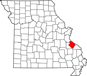
 Location of Ste. Genevieve County | |
| Coordinates: 37°52′45″N 90°19′44″W[1] | |
| Country | United States |
| State | Missouri |
| County | Ste. Genevieve |
| Area | |
| • Total | 92 sq mi (240 km2) |
| • Land | 91.9 sq mi (238 km2) |
| • Water | 0.6 sq mi (2 km2) 0.85% |
| GNIS Feature ID | 767328 |
Name
The origin of the name is not certain, but may be connected to President Andrew Jackson's championship of national unity.[2]
History
Union Township was formed in 1834 out of the western portion of Jackson Township. [3]
Populated places
There are several communities in Union Township. The only incorporated community, Grayhawk, has a population of 408.
The township also contains 6 churches: Chestnut Ridge Baptist Church, Fairview Church, Genevieve Church, Little Vine Church, Salem Church, and Three Rivers Baptist Church, as well as the following cemeteries: Doss, Haile, Jenning, Mackley, McClintock, McGee, Murphy, and Oakland.[4][5]
Geography
Union Township is located in the western portion of Ste. Genevieve County. A number of streams run through the township: Bear Creek, Hickory Creek, North Fork Jonca Creek, and South Fork Jonca Creek. The following lakes are found in the township: Erb Lake, Hart Lake, Lake Genevieve, Lake Ocie, Lake Wanda Lee, Lake Ski, Tragden Lake, and Trautman Lake.[6]
2000 census
The 2000 census shows Union Township consisting of 2,596 individuals.[7] The racial makeup of the town was 2,555 (98.42%) White, 10 (0.38%) African American, 23 (0.88%) Native American and Alaska Native, 2 (0.07%) Asian, and 6 (0.23%) from two or more races.[8]
2010 census
As of the census of 2010, there were 1,399 housing units consisting of 2,779 people, with a population density of 30.5 per square mile residing in the township. Males number 1,294 and make up 50.3% of the population, while females number 1,278 and make up 49.7%. The median age for men is 30.8 years and for women is 37.9. The racial makeup of the town was 2,738 (98.52)% White, 11 (0.40%) African American, 13 (0.47%) Native American and Alaska Native, 1 (0.04%) Asian, and 7 (0.25%) from other races, and 9 (0.32%) from two or more races.[9][10]
The average household size 2.79 persons. The estimated median household income in 2009 was $43,429 ($36,425 in 1999). 13% of the residents have an income below the poverty rate.[11][12][13]
Other Union townships
The Geographic Names Information System (GNIS) records 33 townships named Union in various counties of Missouri.
References
- "Township of Union". Geographic Names Information System. United States Geological Survey. Retrieved January 29, 2014.
- The State Historical Society of Missouri: Ste.Genevieve County Place Names http://shs.umsystem.edu/manuscripts/ramsay/ramsay_sainte_genevieve.html
- Robert Sidney Douglass (1912). Opening the Ozarks: History of Southeast Missouri: A Narrative Account of Its Historical Progress, Its People and Its Principal Interests, Volume 1. ISBN 9780722207536.
- city.data.com http://www.city-data.com/township/Union-Ste.-Genevieve-MO.html
- U.S. Geoview.info http://us.geoview.info/township_of_union,4412662
- U.S. Geoview.info http://us.geoview.info/township_of_union,4412662
- DIANE Publishing (2000). Missouri: 2000 - Census of population and housing (2000): Missouri Summary Population and Housing Characteristics. ISBN 9781428986565.
- DIANE Publishing (2003). Census of population and housing (2000): Missouri Population and Housing Unit Counts. ISBN 9781428985896.
- Places of the USA: "Union township, Missouri state, USA". Archived from the original on December 2, 2013. Retrieved November 24, 2013.
- city.data.com http://www.city-data.com/township/Union-Ste.-Genevieve-MO.html
- City-Data.com http://www.city-data.com/township/Union-Ste.-Genevieve-MO.html
- US Census.gov
- Missouri: 2010 - Population and Housing Unit Counts, 2010 Census of Population and Housing https://www.census.gov/prod/cen2010/cph-2-27.pdf