Hydrologic unit system (United States)
In order to advantage hydrologists, ecologists, and water-resource managers in the study of "water, its properties and laws, and its distribution over the earth's surface" in the United States,[1] the United States Geological Survey created a hierarchical system of hydrologic units.
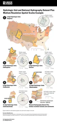
Originally a four-tier system divided into regions, sub-regions, accounting units, and cataloging units, each unit was assigned a unique Hydrologic Unit Code (HUC). As first implemented the system had 21 regions, 221 subregions, 378 accounting units, and 2,264 cataloging units.[2][3] Over time the system was changed and expanded.[4] As of 2010 there are six levels in the hierarchy, represented by hydrologic unit codes from 2 to 12 digits long, called regions, subregions, basins, subbasins, watersheds, and subwatersheds. The table below describes the system's hydrologic unit levels and their characteristics, along with example names and codes.[5]
| Name | Level | Digits | Average size (square miles) |
Number of HUs (approximate) |
Example name | Example code (HUC) |
|---|---|---|---|---|---|---|
| Region | 1 | 2 | 177,560 | 21 | Pacific Northwest | 17 |
| Subregion | 2 | 4 | 16,800 | 222 | Lower Snake | 1706 |
| Basin | 3 | 6 | 10,596 | 370 | Lower Snake | 170601 |
| Subbasin | 4 | 8 | 700 | 2,200 | Imnaha River | 17060102 |
| Watershed | 5 | 10 | 227 (40,000–250,000 acres) | 22,000 | Upper Imnaha River | 1706010201 |
| Subwatershed | 6 | 12 | 40 (10,000–40,000 acres) | 160,000 | North Fork Imnaha River | 170601020101 |
The original delineation of units, down to subbasins (cataloging units), was done using 1:250,000 scale maps and data. The newer delineation work on watersheds and subwatersheds was done using 1:24,000 scale maps and data. As a result, the subbasin boundaries were changed and adjusted in order to conform to the higher resolution watersheds within them. Changes to subbasin boundaries resulted in changes in area sizes. Therefore, older data using "cataloging units" may differ from newer, higher resolution data using "subbasins".[6]
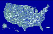
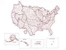
The regions (1st level hydrologic units) are geographic areas that contain either the drainage area of a major river, such as the Missouri region, or the combined drainage areas of a series of rivers, such as the Texas–Gulf region. Each subregion includes the area drained by a river system, a reach of a river and its tributaries in that reach, a closed basin or basins, or a group of streams forming a coastal drainage area.[7] Regions receive a two-digit code. The following levels are designated by the addition of another two digits.[8]
The hierarchy was designed and the units subdivided so that almost all the subbasins (formerly called cataloging units) are larger than 700 square miles (1,800 km2). Larger closed basins were subdivided until their subunits were less than 700 square miles.[7] The 10-digit watersheds were delineated to be between 40,000 and 250,000 acres in size, and the 12-digit subwatersheds between 10,000 and 40,000 acres.[6] In addition to the hydrologic unit codes, each hydrologic unit was assigned a name corresponding to the unit's principal hydrologic feature or to a cultural or political feature within the unit.[7] The boundaries of the hydrologic units usually correspond to drainage basins with some exceptions; for example, subregion 1711, called "Puget Sound", includes all U.S. drainage into not only Puget Sound but also the Strait of Georgia, Strait of Juan de Fuca, and the Fraser River.[9] Also, region and subregion boundaries end at the U.S. international boundary.[7]
The various subdivisions of this system are not necessarily synonymous with watersheds for a number of reasons. As one analysis put it: "The hydrologic unit framework is in fact composed mostly of watersheds and pieces of watersheds. The pieces include units that drain to segments of streams, remnant areas, noncontributing areas, and coastal or frontal units that can include multiple watersheds draining to an ocean or large lake. Hence, half or more of the hydrologic units are not watersheds as the name of the framework Watershed Boundary Dataset (WBD) implies. Nonetheless, hydrologic units and watersheds are commonly treated as synonymous, and this misapplication and misunderstanding can have some serious scientific and management consequences."[10]
Aquifers of the United States are organized by national principal aquifer codes and names assigned by the National Water Information System (NWIS). Aquifers are identified by a geohydrologic unit code (a three-digit number related to the age of the formation) followed by a 4 or 5 character abbreviation for the geologic unit or aquifer name.[11]
 Water resource subregions (4-digit codes)
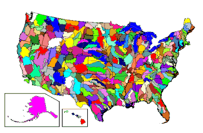 Water resource basins (6-digit codes)
 Water resource subbasins (8-digit codes)
References
- "hydrology". Oxford English Dictionary (Online ed.). Oxford University Press. (Subscription or participating institution membership required.)
- Seaber, Paul R., F. Paul Kapanos, and George L. Knapp (1987). "Hydrologic Unit Maps". United States Geological Survey Water-supply Papers. No. 2294: i–iii, 1–63.
{{cite journal}}: CS1 maint: multiple names: authors list (link) - "Hydrologic Unit Maps - What are Hydrologic Units?". USGS. Retrieved 2010-10-27.
 This article incorporates text from this source, which is in the public domain.
 - "Overview and History of Hydrologic Units and the Watershed Boundary Dataset (WBD)". Natural Resources Conservation Service. 11 January 2022. This article incorporates text from this source, which is in the public domain.
- "Watershed Boundary Dataset (WBD) Facts". Natural Resources Conservation Service. 11 January 2022. This article incorporates text from this source, which is in the public domain.
- "Federal guidelines, requirements, and procedures for the national Watershed Boundary Dataset: U.S. Geological Survey Techniques and Methods 11–A3" (PDF). Natural Resources Conservation Service and United States Geological Survey. 2009. Retrieved 4 November 2010.
- Seaber, Paul R.; Kapinos, F. Paul; Knapp, George L. "Hydrologic Unit Maps, U.S. Geological Survey Water-Supply Paper 2294" (PDF). United States Geological Survey. Retrieved 3 November 2010.
- "Watersheds, Hydrologic Units, Hydrologic Unit Codes, Watershed Approach, and Rapid Watershed Assessments" (PDF). USDA. Archived from the original (PDF) on 2010-10-12. Retrieved 2010-10-27.
- "List Hydrologic Unit Codes (HUCs) - USGS Washington". USGS. Retrieved 19 July 2011.
- Omernik, James M.; Griffith, Glenn E.; Hughes, Robert M.; Glover, James B.; Weber, Marc H. (September 2017). "How Misapplication of the Hydrologic Unit Framework Diminishes the Meaning of Watersheds". Environmental Management. 60 (1): 1–11. doi:10.1007/s00267-017-0854-z. ISSN 0364-152X. PMC 6145848. PMID 28378091.
- "National Aquifer Code Reference List | U.S. Geological Survey". www.usgs.gov. Retrieved 2023-03-19.