Unpa County
Ŭnp'a County is a county in North Hwanghae province, North Korea.
Ŭnp'a County
은파군 | |
|---|---|
| Korean transcription(s) | |
| • Hanja | 銀波郡 |
| • McCune-Reischauer | Ŭnp'a-gun |
| • Revised Romanization | Eunpa-gun |
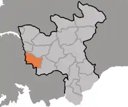 Map of North Hwanghae showing the location of Unpa | |
| Country | North Korea |
| Province | North Hwanghae Province |
| Area | |
| • Total | 389 km2 (150 sq mi) |
| Population (2008[1]) | |
| • Total | 110,988 |
| • Density | 290/km2 (740/sq mi) |
Administrative divisions
Ŭnp'a county is divided into 1 ŭp (town), 1 rodongjagu (workers' districts) and 15 ri (villages):
|
|
Transportation
Ŭnp'a county is served by the Hwanghae Ch'ŏngnyŏn and Ŭllyul lines of the Korean State Railway.

This article is issued from Wikipedia. The text is licensed under Creative Commons - Attribution - Sharealike. Additional terms may apply for the media files.