Upper Bayang
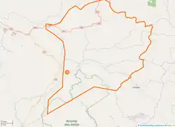
Upper Bayang (sometimes Banyang) is a district of Cameroon located in the Manyu department and the South West region. The district seat is located at Tinto (Tinto Council).[1] Home to the Banyangi people.
Upper Bayang
Nyangiland | |
|---|---|
 Upper Bayang area | |
| Coordinates: 5°46′11″N 8°59′11″E | |
| Country | |
| Region | South West |
| Department | Manyu |
| District Capital | Tinto |
| Area | |
| • Total | 470 sq mi (1,217 km2) |
| Population | |
| • Total | 27,485 |
| Time zone | UTC+1 (WAT) |
At the 2005 census, Upper Bayang had a population of 27,485.
Administrative structure of the municipality
The borough includes the following localities:
- Adjeli
- Agong
- Akiriba
- Amebisu
- Ashum
- Atibong Wire
- Ayukaba Betieku
- Babat
- Bachuo Akagbe
- Batambé
- Bakebe
- Bakumba Batieku
- Bokwa
- Chinda
- Defang
- Ebangabi
- Ebeagwa
- Ebensuk
- Edjuingang
- Egbemoh
- Ekpor
- Etoko
- Etoko-Mbatop
- Eyang Atemako
- Fotabe
- Gurrifen
- Kekpoti
- Kendem
- Kenyang
- Kepelle
- Koano
- Mamboh
- Mantah I
- Mantah II
- Mbanga-Pongo
- Mbeme
- Mbinjong
- Mbio
- Mekwecha
- Moshie
- Nchemba I
- Nchemba II
- Nfainchang
- Nfaitock
- Ntenmbang
- Numba
- Obang 3 Corners
- Sabs
- Sumbe
- Tali I
- Tali II
- Tayor
- Tinto-Kerieh
References
External links
- Site de la primature - Élections municipales 2002 (in French)
- Contrôle de gestion et performance des services publics communaux des villes camerounaises - Thèse de Donation Avele, Université Montesquieu Bordeaux IV (in French)
- Charles Nanga, La réforme de l’administration territoriale au Cameroun à la lumière de la loi constitutionnelle n° 96/06 du 18 janvier 1996, Mémoire ENA. (in French)
This article is issued from Wikipedia. The text is licensed under Creative Commons - Attribution - Sharealike. Additional terms may apply for the media files.