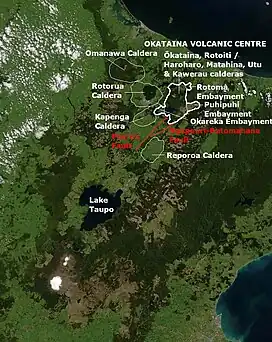
Ōkataina Caldera
Ōkataina Caldera (Ōkataina Volcanic Centre, also spelled Okataina) is a volcanic caldera and its associated volcanoes located in Taupō Volcanic Zone of New Zealand's North Island. It has several actual or postulated sub calderas. The Ōkataina Caldera is just east of the smaller Rotorua Caldera and southwest of the much smaller Rotomā Embayment which is usually regarded as an associated volcano. It shows high rates of explosive rhyolitic volcanism although its last eruption was basaltic. The postulated Haroharo Caldera contained within it has sometimes been described in almost interchangeable terms with the Ōkataina Caldera or volcanic complex or centre and by other authors as a separate complex defined by gravitational and magnetic features.[3]: 14 .[lower-alpha 1] Since 2010 other terms such as the Haroharo vent alignment, Utu Caldera, Matahina Caldera, Rotoiti Caldera and a postulated Kawerau Caldera are often used,[2] rather than a Haroharo Caldera classification.[3]: 2
| Ōkataina Caldera | |
|---|---|
| Ōkataina Volcanic Centre, Okataina Caldera, Okataina Volcanic Centre | |
 Okataina Volcanic Centre relationships to other nearby volcanic and tectonic structures | |
| Highest point | |
| Coordinates | 38°10′S 176°30′E |
| Dimensions | |
| Length | 28 km (17 mi)[1] |
| Width | 15 km (9.3 mi)[1] |
| Geography | |
 Ōkataina Caldera  Ōkataina Caldera Ōkataina Caldera (North Island) | |
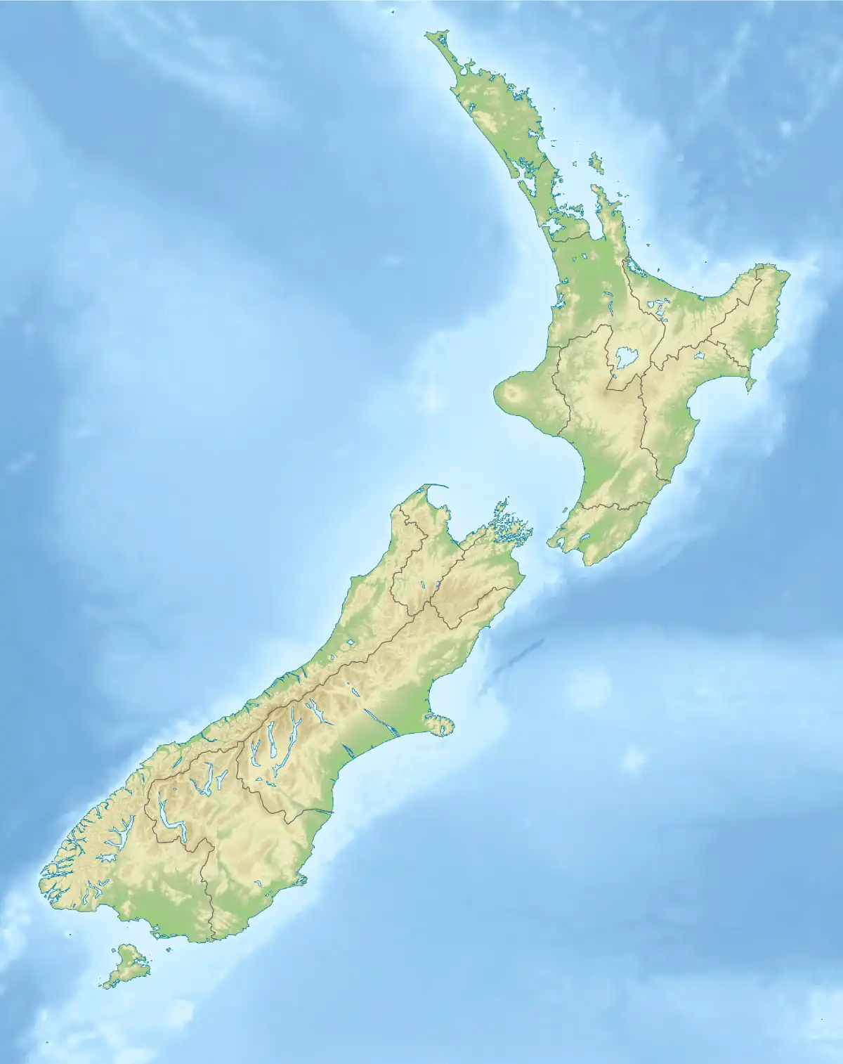
| Country | New Zealand |
| Region | Bay of Plenty |
| Geology | |
| Age of rock | |
| Mountain type | Caldera |
| Volcanic region | Taupō Volcanic Zone |
| Last eruption | 1886 Tarawera, 1973 Hydrothermal in Waimangu Volcanic Rift Valley |
| Climbing | |
| Access | State Highway 5 (New Zealand) |
Geography
The caldera covers an area of about 450 square kilometres (170 sq mi), stretching from Lake Rotoehu in the north to Lake Rotomahana in the south.[4] The north east boundary bisects Lake Rotoiti and the north east includes all of Lake Rotomā. The south west corner is defined by the domes of the Ōkareka Embayment and the Waimangu Volcanic Rift Valley while the south east aspect is dominated by Mount Tarawera and the volcanic badlands of the Puhipuhi Basin. The caldera also contains several lakes, including part or all of Lake Ōkareka, Lake Ōkataina, Lake Rotoehu, Lake Rotomā, Lake Rotoiti, Lake Rotomahana, Lake Tarawera and Lake Tikitapu.[4]
Geology
The overwhelming volcanic deposits are rhyolite, with some basalt and one area of dacite. The caldera is now thought to contain the Utu Caldera, the major event Matahina Caldera, the Rotoiti Caldera, and the Kawerau Caldera with three associated geologically collapse structure embayments.[2] These are Rotomā Embayment, historically regarded as a caldera, the Ōkareka Embayment as another, now in-filled caldera and the Puhipuhi Embayment. The oldest parts of the caldera basement are now over 5 km (3.1 mi) deep and the younger Rotoiti and Kawerau calderas are still 2.5 km (1.6 mi) deep and largely infilled by eruptives.[5][2]
Eruptions
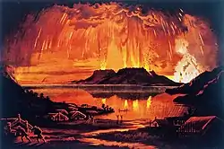
The caldera has seen six eruptions in the past 10,000 years, most recently the 1886 Mount Tarawera eruption in the caldera's southeastern corner. The caldera contains two major lava dome complexes, the Haroharo vent alignment in the north and Tarawera vent alignment in the south. These two vent alignments are associated with current subsidence in the last 20 years of about 1.5 cm/year (0.59 in/year) which is assumed to be because of mainly cooling and contraction of previous magma melt.[6] Other volcanoes connected with the caldera include Putauaki (Mount Edgecumbe) [7] and the maar crater of Lake Rotokawau which is most likely to have formed from a basaltic dike extrusion associated with the common magma mush body.[8]
Threat
While most currently active New Zealand volcanoes produce small eruptions relatively frequently, Ōkataina's volcanoes tend to erupt very violently after intervals of centuries. As such, they pose significant potential threats to the Bay of Plenty Region but are also the most significant volcanic risk in New Zealand.[7] During the last 20,000 years, pyroclastic and lava eruptions have occurred of several types; low-silicate basalt eruptions, high-silicate rhyolite eruptions, and the rarer intermediate andesite and dacite eruptions. The most common magma type at Ōkataina is rhyolite.[7] The warning time before eruptions is currently suspected to be potentially hours as volcanic unrest signals are very non specific, historic composition analysis is consistent with this speed from magma reservoir to surface and this was all the warning given by the only rhyolitic eruption of the modern era.[9]
Eruption mechanism
The underlying arc volcanism is driven initially by large inputs of basaltic melt from the subducted Pacific Plate. These basaltic melts often never reach the surface due to a relatively high density of the magma compared to the surrounding Australian Plate crust, but may trigger earthquake swarms.[10] Usually, these intrusions cool in the crust and then either solidify to a gabbroic igneous intrusion (also known as a pluton) at depth or are associated with the generation of more evolved magmas with higher silicate content that separate. They may then as evolved intrusions, cool further without erupting to form a felsic intrusion or can ascend to then erupt as rhyolite, dacite, or andesite. Sometimes such eruptions are believed to be primed by a basaltic melt predecessor. In the case of the Ōkataina Caldera the sub-surface architecture is known to be made up of discrete melt-mush pockets, and with one dacite exception already mentioned, these are rhyolitic. The melt-mush pockets are mainly between 5 and 8 km (3.1 and 5.0 mi) in depth but one has been characterised at 3 km (1.9 mi) depth.[5] The pockets have erupted compositionally distinct magmas in single eruptions.[2] The composition is related to heat and volatiles transferred between the parent basalts and such rhyolites over the time the sub pocket has been maturing. Basaltic-rhyolitic magma interaction definitely happens from local and world wide studies, and will also be a factor in the many different eruption styles that have occurred.[2] Sometimes basalt appears to lead the eruption, at other times it has been postulated that tectonic earthquakes are the final enabler of an eruption.[2][11]"
Any basaltic magmas that do reach the surface will have traversed this complicated crustal region and may erupt as a dyke. This is believed to have happened with the 1886 Mount Tarawera eruption.[2]
History
It is likely that the volcanic history of the area began some 625,000 years ago.[12] The caldera was formed by at least five huge eruptions between 400,000 and 50,000 years ago.
The oldest eruptive sub caldera is called the Utu caldera and is located in the south central portion. The basement of this sub caldera is about 5 km (3.1 mi) below present ground level.[2]
The most significant collapse event, with an eruptive volume of 150 cubic kilometres (36 cu mi) was 280,000 years ago.[13] This collapse was associated with eruption of the Matahina Ignimbrite which covers over 2,000 km2 (770 sq mi) of the central North Island.[1] The second major phase Matahina sub caldera is to the south east and its basement is also about 5 km (3.1 mi) below present ground level.[2] The original shape of the Matahina caldera has been modified (and buried/destroyed) by various events including at least eight smaller eruptions between 70,000 and 24,000 years ago. For example the dacite Puripuri basin/embayment is a subsidence related feature. This subsidence is related to the lateral movement of the underlying magma towards the eastern caldera margins.[2]
The paired eruptions approximately 50,000 years ago[14] of Rotoiti and at Earthquake Flat at far northern and southern ends of the caldera respectively had eruptive volumes of 120 cubic kilometres (29 cu mi) and 10 cubic kilometres (2.4 cu mi).[1] The resulting Rotoiti sub caldera is to the north of the Utu Caldera.[2]
Between this eruption and 21,000 years ago over 81 km3 (19 cu mi) of Mangaone silicic plinian tephras or pyroclastic flow deposits occurred but it is unknown where the eruptions were centered. One of these events can be assigned to the Kawerau ignimbrite eruption of 33,000 years ago, with its location within the central part of the Matahina Caldera at level of the Puhipuhi Basin.[1] An area of low gravity on gravimetric studies is consistent with the fourth phase Kawerau Caldera being here and its basement being about 2 km (1.2 mi) below present ground level.[2]
Although the latest caldera models include the Haroharo vent alignment they do not allow for the separate existence of a Haroharo caldera as many had historically postulated existed.[2]
More recently volcanoes within the caldera are known to have erupted eleven times in the last 21,000 years, with all but two of those eruptions being rhyolite.[15][7] The Rotoma eruptions occurred in a north eastern embayment, and again like with the case of the Puripuri basin, the magma erupted from a lateral reservoir is associated with subsidence back to the eastern Rotoiti caldera margin. The Ōkareka Embayment to the west is also associated with caldera rim subsidence, this time the western shared rims of the Utu, Matahina and Rotoiti calderas.[2]
Two of these eruptions, both at Tarawera, occurred within the last 2000 years (in 1886 and c. 1314AD). The most explosive of the eruptions in the last 21,000 years is likely to have been on the Haroharo vent alignment at about 5500 BCE. This ejected some 17 km3 (4.1 cu mi) of magma.[7] During the last 21,000 years the Ōkataina volcano has contributed a total magma eruptive volume of about 80 km3 (19 cu mi) in all its eruptions.[15][16]
In summary the more significant eruptions have been:[13][12][1]
| Year before present | Calendar date | Eruptive name | Vent / Vent alignment / Caldera | Volume erupted | Notes |
|---|---|---|---|---|---|
| 137 cal.yr | 10 June 1886 CE | Tarawera | Tarawera | 1 km3 (0.24 cu mi) DRE | Basaltic eruption[13][12][1][17] |
| 709 ± 12 cal.yr | 1314 ± 12 CE | Kaharoa tephra | Tarawera | 5 km3 (1.2 cu mi) DRE | [13][18][17] |
| 5526 ± 145 cal.yr | 3576 ± 145 BCE | Whakatane | Haroharo | 13 km3 (3.1 cu mi) DRE | [13][17] |
| 7940 ± 257 cal.yr | 5990 ± 257 BCE | Mamaku | Haroharo | 17 km3 (4.1 cu mi) DRE | [13][19][17] |
| 9423 ± 120 cal.yr | 7473 ± 120 BCE | Rotoma | Haroharo | 8 km3 (1.9 cu mi) DRE | [13][17] |
| 14,009 ± 155 cal.yr | 12059 ± 155 BCE | Waiohau tephra | Tarawera | 10 km3 (2.4 cu mi) DRE | [13][17] |
| 15,635 ± 412 cal.yr | 13685 ±412 BCE | Rotorua tephra | Haroharo | 4 km3 (0.96 cu mi) DRE | [13][17] |
| 17,496 ± 462 cal.yr | 15546 ± 462 BCE | Rerewhakaaitu tephra | Tarawera | 5 km3 (1.2 cu mi) DRE | [13][20][17] |
| 23,525–370+230 cal.yr | 21575 BCE | Okareka | Tarawera | 8 km3 (1.9 cu mi) DRE | [13][19][17] |
| 25,171 ± 964 cal.yr | 23221 BCE | Te Rere | Kawerau Caldera (Haroharo) | 13 km3 (3.1 cu mi) DRE | [13]33,000 years ago Kawerau (previously called Kaingaroa and miss-assigned to be 200,000 years older)[1] now corrected to 25,171 years ago[17] |
| 31,500 cal.yr | 29550 BCE | Unit L | Unknown | 8.1 km3 (1.9 cu mi) Tephra | [21][22] |
| 32,500 cal.yr | 30550 BCE | Omataroa | Unknown | 16.2 km3 (3.9 cu mi) Tephra | [21][22] |
| 32,800 cal.yr | 30850 BCE | Awakeri | Unknown | 0.77 km3 (0.18 cu mi) Tephra | [21][22] |
| 33,000 cal.yr | 31050 BCE | Mangaone | Unknown | 19.1 km3 (4.6 cu mi) Tephra | [21][22] |
| 34,500 cal.yr | 32550 BCE | Unit H | Unknown | 0.1 km3 (0.024 cu mi) Tephra | [21][22] |
| 35,000 cal.yr | 33050 BCE | Unit G | Unknown | 2.5 km3 (0.60 cu mi) Tephra | [21][22] |
| 36,100 cal.yr | 34150 BCE | Hauparu | Unknown | 15.2 km3 (3.6 cu mi) Tephra | [21][22] |
| 36,700 cal.yr | 34750 BCE | Te Mahoe | Unknown | 0.9 km3 (0.22 cu mi) Tephra | [21][22] |
| 36,800 cal.yr | 34850 BCE | Maketu | Unknown | 11 km3 (2.6 cu mi) Tephra | [21][22] |
| 38,000 approx. cal.yr | 36050 BCE | Unit C (Pupuwharau then Pongakawa) | Unknown | 0.7 km3 (0.17 cu mi) Tephra | [21][22] |
| 39,000 approx. cal.yr | 37050 BCE | Ngamotu | Unknown | 4.6 km3 (1.1 cu mi) Tephra | [21][22] |
| 40,000 approx. cal.yr | 38050 BCE | Unit A | Unknown | 0.44 km3 (0.11 cu mi) Tephra | [21] |
| 49,000 approx. cal.yr | 47050 BCE | Earthquake Flat | Earthquake Flat | [21] | |
| about 50,000 cal.yr | 48050 BCE | Rotoiti/Rotoehu tephra | Rotoiti Caldera (Haroharo)' | 130 km3 (31 cu mi) DRE | Basalt was emplaced on the floor of the rhyolitic reservoir.[21] [lower-alpha 2][22] |
| 50,000 + cal.yr | 48050 BCE | Matahi Scoria | Suspected to be Rotoiti Caldera | Basaltic immediately pre-Rotoiti[16][21] | |
| about 51,000 | 49050 BCE | Puhipuhi Dacite | Puhipuhi Embayment | 48,000+[1] ie is definitely before Rotoiti but age depends on actual Rotoiti age. | |
| 96,000 approx. cal.yr | 94050 BCE | Moerangi | Moerangi Dome | [21] | |
| 188,000 approx. cal.yr | 186050 BCE | Tutaeheke/Hap-Kapenga | Tutaeheke Dome | [21] | |
| 240,000 + cal.yr | 238050 BCE | Pokopoko pyroclastics | Unknown | [21] | |
| 240,000 + cal.yr | 238050 BCE | Onuku pyroclastics | Unknown | [21] | |
| 280,000 cal.yr | 278000 BCE | Matahina | Matahina Caldera | 150 km3 (36 cu mi) DRE | Recharging basalt found on top igmibrite layer.[21] [13] The latest age (not literature peer reviewed) is claimed at 322,000 ± 7,000 [23] which appears to be a reversion to the initial uncorrected timing. Also previously timed 230,000.[1] - large as caldera collapse |
| 280,000 + cal.yr | 280000 BCE | Matawhaura | Matawhaura Dome | [21] | |
| 280,000 + cal.yr | 280000 BCE | Murupara pyroclastics | Unknown | [21] | |
| 280,000 + cal.yr | 280000 BCE | Wairua | Wairua Dome | [21] | |
| 280,000 + cal.yr | 280000 BCE | Maunawhakamana | Maunawhakamana Dome | [21] | |
| 280,000 + cal.yr | 280000 BCE | Whakapoungakau | Whakapoungakau Dome | Lost volume with Matahini eruption[21] | |
| 557,000 cal.yr | 555000 BCE | Utu | Utu Caldera | [16] | |
| 625,000 cal.yr | 623000 BCE | Ōkataina | Ōkataina | [12] |
Tectonics
Faults are not defined under this very active caldera. The active Paeroa Fault terminates at the caldera edge and the active Ngapouri-Rotomahana Fault is just to the south. The two recently active main vent alignments in the Ōkataina Caldera, the Horahora and Tarawera vents, are parallel with these identifiable faults outside the caldera, although the faults are not on the exact vent line.[1] In the last 9,500 years, four of the seven major ruptures of the Manawahe Fault have been associated in time with a volcanic eruption of the Okataina volcanic centre. This fault is just to the east of Lake Rotoma at the boundary between the tectonic Whakatāne Graben and the magmatic Ōkataina segments of the Taupō Rift. These are the Whakatane eruption of about 5500 years ago, the Mamaku eruption of about 8000 years ago and at least two fault ruptures in before or during the Rotoma eruption of 9500 years ago.[13] Similarly the Ngapouri-Rotomahana Fault and Paeroa Fault have multiple ruptures associated in time with volcanism including immediately prior to the Mamaku and Rotoma rhyolite eruptions in the case of the Paeroa Fault and of the Ngapouri-Rotomahana Fault immediately prior to the Kaharoa eruption.[11] At least 30% of major Taupō Volcanic Zone eruptions have now been associated with significant local fault ruptures within 30 km (19 mi) of the eruption.[13]
Notes
- Possibly started from
HaroHaro pile ... are rhyolite lavas of the Okataina Volcanic Centre, extruded on the floor of Haroharo Caldera
with the author presuming that certain ignimbrites came from this source. The term Haroharo Caldera was increasingly used in academic papers in the 1970's and 1980's but changed as the detailed geology became better understood. The difficulty was that by then the term Haroharo Caldera was established. The term is still used, and currently is defined by gravity and magnetic differences.— J. Healy, Geology of the Rotoroa District 1962, p54-55 - Ages assigned to the Rotoiti/Rotoehu eruptives currently appear to vary depending upon methodology by about 15,000 years in the literature. This is problematic as many ages of volcanics in the Northern North Island would be more definite if a single agreed value existed. The issue of previous inaccurate age assignment started with a new figure for Rotoehu Ash of 64,000 ± 1650 cal.yr.(Wilson et al 1992) which was initially widely accepted. The youngest age assigned is 44,300 years ago (Shane et al 2003). The problems with some older techniques were possibly not resolved with new techniques that could explain the discrepancy and that resulted in 47,400 ± 1500 years ago (Flude et al 2016), as one recent peer reviewed work gave 61,000 ± 1400 cal.yr (Villamor et al 2022). Other chronology studies have a younger date of 45,200 ± 1650 cal.yr. (Danišík et al 2020 and 2012), 47,400 ± 1500 years ago (Gilgour et al 2008), and before these 65,000 years ago (Spinks 2005). For more on this age issue see notes to Puhipuhi Embayment.
References
- Spinks, Karl D. (2005). Rift Architecture and Caldera Volcanism in the Taupo Volcanic Zone, New Zealand (Thesis).
- Hughes, Ery C.; Law, Sally; Kilgour, Geoff; Blundy, Jon D.; Mader, Heidy M. (2023). "Storage, evolution, and mixing in basaltic eruptions from around the Okataina Volcanic Centre, Taupō Volcanic Zone, Aotearoa New Zealand". Journal of Volcanology and Geothermal Research. 434 (107715): 107715. doi:10.1016/j.jvolgeores.2022.107715. ISSN 0377-0273. S2CID 253783414.
- Caratori Tontini, F; de Ronde, CEJ; Black, J; Stucker, VK; Walker, SL (2023). "The geology and geophysics of Lake Tarawera, New Zealand: Implications for sublacustrine geothermal activity". Journal of Volcanology and Geothermal Research. 433. doi:10.1016/j.jvolgeores.2022.107731. ISSN 0377-0273.
- McKinnon, M., "Okataina caldera and its neighbours," Te Ara - Encyclopedia of New Zealand, 1 May 2015. Retrieved 11 June 2022.
- Bannister, Stephen; Bertrand, Edward A.; Heimann, Sebastian; Bourguignon, Sandra; Asher, Cameron; Shanks, Jackson; Harvison, Adrian (2022). "Imaging sub-caldera structure with local seismicity, Okataina Volcanic Centre, Taupo Volcanic Zone, using double-difference seismic tomography". Journal of Volcanology and Geothermal Research. 431 (107653). doi:10.1016/j.jvolgeores.2022.107653. ISSN 0377-0273.
- Hamling, Ian J.; Kilgour, Geoff; Hreinsdóttir, Sigrun; Bertrand, Edward; Bannister, Stephen (2022). "Estimating the distribution of melt beneath the Okataina Caldera, New Zealand: An integrated approach using geodesy, seismology and magnetotellurics". Journal of Volcanology and Geothermal Research. 426 (107549). doi:10.1016/j.jvolgeores.2022.107549. ISSN 0377-0273.
- "Okataina Volcanic Centre Geology," GNS science. Retrieved 11 June 2022.
- Bertrand, E.A.; Kannberg, P.; Caldwell, T.G.; Heise, W.; Constable, S.; Scott, B.; Bannister, S.; Kilgour, G.; Bennie, S.L.; Hart, R.; Palmer, N. (2022). "Inferring the magmatic roots of volcano-geothermal systems in the Rotorua Caldera and Okataina Volcanic Centre from magnetotelluric models". Journal of Volcanology and Geothermal Research. 431 (107645): 107645. doi:10.1016/j.jvolgeores.2022.107645. ISSN 0377-0273. S2CID 251526385.
- Rooyakkers, S.M.; Faure, K.; Chambefort, I.; Barker, S.J.; Elms, H.C.; Wilson, C.J.; Charlier, B.L. (2023). "Tracking Magma‐Crust‐Fluid Interactions at High Temporal Resolution: Oxygen Isotopes in Young Silicic Magmas of the Taupō Volcanic Zone". Geochemistry, Geophysics, Geosystems. 24 (1). doi:10.1029/2022GC010694. S2CID 254807245.
- Benson, Thomas W.; Illsley-Kemp, Finnigan; Elms, Hannah C.; Hamling, Ian J.; Savage, Martha K.; Wilson, Colin J. N.; Mestel, Eleanor R. H.; Barker, Simon J. (2021). "Earthquake Analysis Suggests Dyke Intrusion in 2019 Near Tarawera Volcano, New Zealand". Frontiers in Earth Science. 8. doi:10.3389/feart.2020.606992. ISSN 2296-6463.
- Berryman, Kelvin; Villamor, Pilar; Nairn, Ian; Begg, John; Alloway, Brent V.; Rowland, Julie; Lee, Julie; Capote, Ramon (2022). "Volcano-tectonic interactions at the southern margin of the Okataina Volcanic Centre, Taupō Volcanic Zone, New Zealand". Journal of Volcanology and Geothermal Research. 427 (107552): 107552. doi:10.1016/j.jvolgeores.2022.107552. ISSN 0377-0273. S2CID 248111450.
- Cole, J.W., Deer ing, C.D., et al (2014) "Okataina Volcanic Centre, Taupo Volcanic Zone, New Zealand: A review of volcanism and synchronous pluton development in an active, dominantly silicic caldera system", Earth-science reviews, 128, 1–17. Abstract retrieved 11 June 2022.
- Villamor, Pilar; Litchfield, Nicola J.; Gómez-Ortiz, David; Martin-González, Fidel; Alloway, Brent V.; Berryman, Kelvin R.; Clark, Kate J.; Ries, William F.; Howell, Andrew; Ansell, India A. (2022). "Fault ruptures triggered by large rhyolitic eruptions at the boundary between tectonic and magmatic rift segments: The Manawahe Fault, Taupō Rift, New Zealand". Journal of Volcanology and Geothermal Research. 427: 107478. doi:10.1016/j.jvolgeores.2022.107478. ISSN 0377-0273. S2CID 246258923.
- Gilgour, G.N.; Smith, R.T. (2008). "Stratigraphy, dynamics, and eruption impacts of the dual magma Rotorua eruptive episode, Okataina Volcanic Centre, New Zealand" (PDF). New Zealand Journal of Geology & Geophysics. 51 (4): 367–378. doi:10.1080/00288300809509871. S2CID 128976717.
- Smith, Victoria; Shane, Phil; Nairn, I.A.; Williams, Catherine (2006-07-01). "Geochemistry and magmatic properties of eruption episodes from Haroharo linear vent zone, Okataina Volcanic Centre, New Zealand during the last 10 kyr". Bulletin of Volcanology. 69 (1): 57–88. doi:10.1007/s00445-006-0056-7. S2CID 129365367.
- Cole, J. W.; Spinks, K. D. (2009). "Caldera volcanism and rift structure in the Taupo Volcanic Zone, New Zealand". Special Publications. London: Geological Society. 327 (1): 9–29. Bibcode:2009GSLSP.327....9C. doi:10.1144/SP327.2. S2CID 131562598.
- Lowe, David; Ilanko, Tehnuka. "Pre-conference tephra data workshop – Hands-on session II: tephra excursion, Okareka Loop Road (29 January 2023)". Retrieved 2023-03-21.
- Froggatt, P. C.; Lowe, D. J. (1990). "A review of late Quaternary silicic and some other tephra formations from New Zealand: Their stratigraphy, nomenclature, distribution, volume, and age". New Zealand Journal of Geology and Geophysics. 33 (1): 89–109. doi:10.1080/00288306.1990.10427576.
- Darragh, Miles; Cole, Jim; Nairn, Ian; Shane, Phil (2006). "Pyroclastic stratigraphy and eruption dynamics of the 21.9 ka Okareka and 17.6 ka Rerewhakaaitu eruption episodes from Tarawera Volcano, Okataina Volcanic Centre, New Zealand". New Zealand Journal of Geology and Geophysics. 49 (3): 309–328. doi:10.1080/00288306.2006.9515170. S2CID 59137127.
- Shane, Phil; Martin, S.B.; Smith, Victoria C.; Beggs, K.R. (2007). "Multiple rhyolite magmas and basalt injection in the 17.7 ka Rerewhakaaitu eruption episode from Tarawera volcanic complex, New Zealand". Journal of Volcanology and Geothermal Research. 164 (1–2): 1–26. doi:10.1016/j.jvolgeores.2007.04.003.
- Bouvet de Maisonneuve, C.; Forni, F.; Bachmann, O. (2021). "Magma reservoir evolution during the build up to and recovery from caldera-forming eruptions – A generalizable model?". Earth-Science Reviews. 218: 103684. doi:10.1016/j.earscirev.2021.103684. hdl:10356/161241. ISSN 0012-8252. S2CID 236237501.
- Danišík, Martin; Lowe, David J.; Schmitt, Axel K.; Friedrichs, Bjarne; Hogg, Alan G.; Evans, Noreen J. (2020). "Sub-millennial eruptive recurrence in the silicic Mangaone Subgroup tephra sequence, New Zealand, from Bayesian modelling of zircon double-dating and radiocarbon ages" (PDF). Quaternary Science Reviews. 246: 106517. doi:10.1016/j.quascirev.2020.106517. hdl:10289/13801. ISSN 0277-3791. S2CID 224864954.
- Kidd, Maia Josephine (2021). Landscape Evolution in Ignimbrite Terrain: a study of the Mamaku Plateau, Taupō Volcanic Zone, New Zealand - Masters thesis, University of Canterbury (PDF) (Thesis).