Vangaindrano (district)
Vangaindrano is a district of Atsimo-Atsinanana in Madagascar.[1][2]
Vangaindrano | |
|---|---|
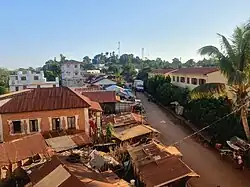 | |
 Vangaindrano Location in Madagascar | |
| Coordinates: 23°21′S 47°36′E | |
| Country | |
| Region | Atsimo-Atsinanana |
| District | Vangaindrano |
| Elevation | 9 m (30 ft) |
| Time zone | UTC3 (EAT) |
| Postal code | 320 |
Municipalities
The district is further divided into 28 municipalities:
Geography
Vangaindrano is near the mouth of the Mananara River at the southern part of the east coast.
Roads
It's connected to the north by National Road RN 12 to Farafangana that is situated at a distance of 75 km in the North. The road continues south as National Road 12a to Fort Dauphin but this section can hardly be by ordinary vehicles, due to its bad condition and lack of bridges..
- RN T18 to Nosifeno and the Midongy du sud National Park.
Nature
The Midongy Atsimo National Park is situated at 90 km from Vangaindrano and the Manombo Reserve, halfway to Farafangana.
References
- REPOBLIKAN’I MADAGASIKARA:Tanindrazana – Fahafahana – Fandrosoana (PDF). MINISTERE DE L’AGRICULTURE, DE L’ELEVAGE ET DE LA PECHE. October 2007. pp. 42–44.
- "Madagascar: Administrative Division". citypopulation. Retrieved 10 June 2018.
Capital: Farafangana | ||
| Befotaka Sud (6) - 307 |  | |
| Farafangana (30) - 309 |
| |
| Midongy-Atsimo (6) - 318 | ||
| Vangaindrano (28) - 320 | ||
| Vondrozo (16) - 322 | ||
5 districts; 86 communes | ||
Wikimedia Commons has media related to Vangaindrano.
This article is issued from Wikipedia. The text is licensed under Creative Commons - Attribution - Sharealike. Additional terms may apply for the media files.