Villariès
Villariès (French pronunciation: [vilaʁjɛs]; Occitan: Vilariès) is a commune in the Haute-Garonne department in southwestern France.
Villariès | |
|---|---|
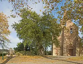 The oak of Sully and the church in Villariès | |
.svg.png.webp) Coat of arms | |
Location of Villariès | |
 Villariès  Villariès | |
| Coordinates: 43°45′15″N 1°29′34″E | |
| Country | France |
| Region | Occitania |
| Department | Haute-Garonne |
| Arrondissement | Toulouse |
| Canton | Pechbonnieu |
| Government | |
| • Mayor (2020–2026) | Léandre Roumagnac[1] |
| Area 1 | 7.33 km2 (2.83 sq mi) |
| Population | 796 |
| • Density | 110/km2 (280/sq mi) |
| Time zone | UTC+01:00 (CET) |
| • Summer (DST) | UTC+02:00 (CEST) |
| INSEE/Postal code | 31579 /31380 |
| Elevation | 127–203 m (417–666 ft) (avg. 180 m or 590 ft) |
| 1 French Land Register data, which excludes lakes, ponds, glaciers > 1 km2 (0.386 sq mi or 247 acres) and river estuaries. | |
Population
| Year | Pop. | ±% |
|---|---|---|
| 1962 | 198 | — |
| 1968 | 208 | +5.1% |
| 1975 | 239 | +14.9% |
| 1982 | 377 | +57.7% |
| 1990 | 523 | +38.7% |
| 1999 | 592 | +13.2% |
| 2006 | 770 | +30.1% |
| 2007 | 796 | +3.4% |
| 2008 | 805 | +1.1% |
| 2012 | 821 | +2.0% |
| 2015 | 812 | −1.1% |
| 2017 | 792 | −2.5% |
| 2018 | 796 | +0.5% |
Sights
The Château de Jean is a château built on the site of an older castle and listed since 1998 as a historic site by the French Ministry of Culture.[3]
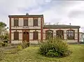 Town hall
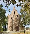 Church
References
- "Répertoire national des élus: les maires". data.gouv.fr, Plateforme ouverte des données publiques françaises (in French). 2 December 2020.
- "Populations légales 2020". The National Institute of Statistics and Economic Studies. 29 December 2022.
- Base Mérimée: Château de Jean, Ministère français de la Culture. (in French)
Wikimedia Commons has media related to Villariès.
This article is issued from Wikipedia. The text is licensed under Creative Commons - Attribution - Sharealike. Additional terms may apply for the media files.