Vilna Governorate
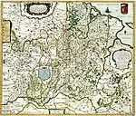
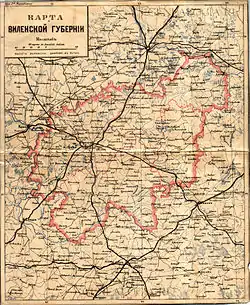
The Vilna Governorate[lower-alpha 1] was a governorate (guberniya) of the Northwestern Krai of the Russian Empire. In 1897, the governorate covered the area of 41,907.9 square kilometres (16,180.7 sq mi) and a population of 1,591,207 inhabitants. The governorate was defined by the Minsk Governorate to the south, the Grodno Governorate to the southwest, the Suwałki Governorate to the west, the Kovno and Courland Governorates to the north, and the Vitebsk Governorate to the east. The administrative centre was located in the city of Vilna (which is modern-day Vilnius). The city also served as the administrative centre of the Vilna Governorate-General, which existed until 1912. The area roughly corresponded to the Vilnius Region, which was later occupied by Germany, Bolsheviks, and Poland.
Vilna Governorate
| |
|---|---|
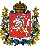 Coat of arms | |
.svg.png.webp) Location in the Russian Empire | |
| Country | Russian Empire |
| Krai | Northwestern |
| Established | 1795 |
| Abolished | 1918 |
| Capital | Vilna |
| Area | |
| • Total | 41,907.9 km2 (16,180.7 sq mi) |
| Highest elevation | 293.84 m (964.04 ft) |
| Population (1897) | |
| • Total | 1,591,207 |
| • Density | 38/km2 (98/sq mi) |
| • Urban | 12.44% |
| • Rural | 87.56% |
| History of Lithuania |
|---|
 |
| Chronology |
|
|
_(1845).png.webp)
History
The first governorates, Vilnius Governorate (consisting of eleven uyezds or districts) and Slonim Governorate, were established after the third partition of the Polish-Lithuanian Commonwealth. Just a year later, on December 12, 1796, by order of Tsar Paul I they were merged into one governorate, called the Lithuanian Governorate, with its capital in Vilnius.[1] By order of Tsar Alexander I on September 9, 1801, the Lithuanian Governorate was split into the Lithuania-Vilnius Governorate and the Lithuania-Grodno Governorate. After 39 years, the word "Lithuania" was dropped from the two names by Nicholas I.[2]
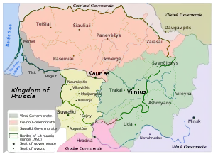
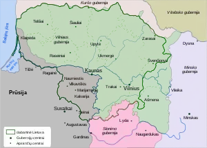
In 1843, another administrative reform took place, creating the Kovno Governorate (Kovno in Russian) out of seven western districts of the Vilnius Governorate, including all of Samogitia. The Vilnius Governorate received three additional districts: Vileyka and Dzisna from the Minsk Governorate and Lida from Grodno Governorate.[3] It was divided to districts of Vilnius, Trakai, Disna, Oshmyany, Lida, Vileyka and Sventiany. This arrangement remained unchanged until World War I. A part of the Vilnius Governorate was then included in the Lithuania District of Ober-Ost, formed by the occupying German Empire.
During the Polish–Soviet War, the area was annexed by Poland. The Council of Ambassadors and the international community (with the exception of Lithuania) recognized Polish sovereignty over the Vilnus region in 1923.[4] In 1923, the Wilno Voivodeship was created, which existed until 1939, when the Soviet Union occupied Lithuania and Poland and returned most, but not all, of the Polish-annexed land to Lithuania.
Demographics
| Language | People |
|---|---|
| Lithuanian | 780,000 |
| Yiddish | 180,000 |
| Polish | 100,000 |
| Russians | 80,000 |
| Ruthenians | 50,000 |
| Tatars | 10,000 |
| Total | 1,200,000 |
In 1834, the Vilnius Governorate had about 789,000 inhabitants; by 1897, the population had grown to about 1,591,000 residents[6] (37 per km2).
Russian Empire Census
According to the Russian Empire census on 28 January [O.S. 15 January] 1897, The Vilna Governorate had a population of 1,591,207, including 790,880 men and 800,327 women. The majority of the population indicated Belarusian to be their mother tongue, which followed by a significant Lithuanian and Jewish speakers.[7]
| Language | Native speakers | Percentage |
|---|---|---|
| White Russian[lower-alpha 2] | 891,903 | 56.05 |
| Lithuanian | 279,720 | 17.58 |
| Jewish | 202,374 | 12.72 |
| Polish | 130,054 | 8.17 |
| Great Russian[lower-alpha 2] | 78,623 | 4.94 |
| German | 3,873 | 0.24 |
| Tatar | 1,969 | 0.12 |
| Ukrainian[lower-alpha 2] | 919 | 0.06 |
| Latvian | 471 | 0.03 |
| Gypsi | 182 | 0.01 |
| Others | 1,119 | 0.07 |
| Total | 1,591,207 | 100.00 |
| Faith | Male | Female | Both | |
|---|---|---|---|---|
| Number | Percentage | |||
| Roman Catholic | 460,627 | 475,222 | 935,849 | 58.81 |
| Eastern Orthodox | 214,225 | 201,070 | 415,295 | 26.10 |
| Judaism | 98,193 | 106,493 | 204,686 | 12.86 |
| Old Believer | 12,686 | 12,987 | 25,673 | 1.61 |
| Lutheranism | 2,172 | 2,291 | 4,463 | 0.28 |
| Islam | 2,572 | 1,803 | 4,375 | 0.27 |
| Karaite | 251 | 325 | 576 | 0.04 |
| Reformed | 92 | 85 | 177 | 0.01 |
| Armenian Catholic | 22 | 25 | 47 | 0.00 |
| Armenian Apostolic | 9 | 3 | 12 | 0.00 |
| Mennonite | 2 | 0 | 2 | 0.00 |
| Anglican | 0 | 2 | 2 | 0.00 |
| Other Christian denomination | 19 | 16 | 35 | 0.00 |
| Other non-Christian denomination | 10 | 4 | 14 | 0.00 |
| Total | 790,880 | 800,327 | 1,591,207 | 100.00 |
Between 1944 and 1946, about 150,000 people, mostly but not all of Polish extraction left the area for Poland (about 10% of this group may have been Lithuanians hoping to escape Soviet rule). Between 1955 and 1959, another 46,000 Polish-speakers left Lithuania (see the Demographic history of the Vilnius region). Meanwhile, the Jewish population of the area, just as in the rest of Lithuania, was virtually exterminated by the Nazis during World War II. As of 2001, ethnic Lithuanians once again predominated within the city of Vilnius (59%), but the area of the former governorate as a whole remained about 62% Polish, with the percentage of Russians (8.6) and Belarusians (4.4) having dwindled to a tiny minority.
Subdivisions
The counties (uezd) of the Vilna Governorate in 1897 was composed of seven uezds as follows:[7]
| County | Capital | Arms of capital | Area | Population (1897 census) | |
|---|---|---|---|---|---|
| Transliteration name | Russian Cyrillic | ||||
| Vileyskiy | Вилейскій | Vileyka | 6,363.13 km2 (2,456.82 sq mi) | 208,013 | |
| Vilenskiy | Виленскій | Vilna | 6,185.14 km2 (2,388.10 sq mi) | 363,313 | |
| Disnenskiy | Дисненскій | Disna | 5,779.30 km2 (2,231.40 sq mi) | 204,923 | |
| Lidskiy | Лидскій | Lida | 5,606.20 km2 (2,164.57 sq mi) | 205,767 | |
| Oshmyanskiy | Ошмянскій | Oshmyany | 6,885.39 km2 (2,658.46 sq mi) | 233,559 | |
| Sventsyanskiy | Свѣнцянскій | Sventsyany | 5,228.03 km2 (2,018.55 sq mi) | 172,231 | |
| Trokskiy | Трокскій | Troki | 5,862.27 km2 (2,263.44 sq mi) | 203,401 | |
Ethnic composition
Russian authorities periodically performed censuses. However, they reported strikingly different numbers:[11]
| Year | Total | Lithuanians | Poles | Belarusians | Russians | Jews | Other | ||||||
|---|---|---|---|---|---|---|---|---|---|---|---|---|---|
| 1862 | 838,464 | 418,880 | 50% | 154,386 | 18% | 146,431 | 17% | 14,950 | 2% | 76,802 | 9% | 27,035 | 3% |
| 1865 | 891,715 | 210,273 | 24% | 154,386 | 17% | 418,289 | 47% | 27,845 | 3% | 76,802 | 9% | 4,120 | 0% |
| 1883 | 1,192,000 | 417,200 | 35% | 281,312 | 24% | 239,592 | 20% | - | 176,416 | 15% | 77,480 | 7% | |
| 1897 | 1,561,713 | 274,414 | 18% | 126,770 | 8% | 880,940 | 56% | 75,803 | 5% | 197,929 | 13% | 5,857 | 0% |
| 1909 | 1,550,057 | 231,848 | 15% | 188,931 | 12% | 570,351 | 37% | 408,817 | 26% | 146,066 | 9% | 4,094 | 0% |
Governors
| Name | In office |
|---|---|
| Yakov Bulgarov | 1797–1799 |
| Ivan Friesell | 1799–1801 |
| Dmitry Lanskoy | 1802–1804 |
| Ivan Rickman | 1804–1806 |
| Prokopy Bogmevsky | 1806–1808 |
| Nikolay Brusilov | 1808–1810 |
| Aleksandr Lavinsky | 1811–1816 |
| Friedrich Drutsky-Lyubetsky | 1816–1823 |
| Pyotr Gorn | 1823–1830 |
| Dmitry Obreskov | 1830–1832 |
| Grigory Doppelmayr | 1832–1836 |
| Dmitry Bantysh-Kamensky | 1836–1838 |
| Yuri Dolgorukov | 1838–1840 |
| Aleksey Semyonov | 1840–1844 |
| Nikolay Zherebtsov | 1844–1846 |
| Mikhail Begichev | 1846–1851 |
| Arkady Rosset | 1851–1857 |
| Mikhail Pokhvisnev | 1857–1863 |
| Ivan Galler | 1863–1863 |
| Stepan Panyutin | 1863–1868 |
| Ivan Shestakov | 1868–1869 |
| Yegor Steblin-Kamensky | 1869–1882 |
| Aleksandr Zhemchuzhnikov | 1882–1885 |
| Nikolay Grevenits | 1885–1895 |
| Aleksandr Frese | 1895–1896 |
| Ivan Cheplevsky | 1896–1899 |
| Nikolai Gruzinsky | 1899–1901 |
| Viktor Wahl | 1901–1902 |
| Konstantin Palen | 1902–1905 |
| Sergey Tatishchev | 1905–1906 |
| Dmitry Lyubimov | 1906–1912 |
| Pyotr Veryovkin | 1912–1916 |
| Aleksandr Tolstoy | 1916–1917 |
Notes
-
- Russian: Ви́ленская губе́рнія, romanized: Vílenskaya gubérniya
- Lithuanian: Vilniaus gubernija
- Polish: gubernia wileńska
- Prior to 1918, the Imperial Russian Government classified Russians as the Great Russians, Ukrainians as the Little Russians, and Belarusians as the White Russians. After the creation of the Ukrainian People's Republic in 1918, the Little Russians identified themselves as "Ukrainian".[8] Also, the Belarusian Democratic Republic which the White Russians identified themselves as "Belarusian".[9]
References
- Kulakauskas, Antanas (2002). "Administracinės reformos". Gimtoji istorija. Nuo 7 iki 12 klasės (in Lithuanian). Vilnius: Elektroninės leidybos namai. ISBN 9986-9216-9-4. Archived from the original on 2008-03-03. Retrieved 2008-01-01.
- "Литовская губерния". Brockhaus and Efron Encyclopedic Dictionary (in Russian). 1890–1906.
- Simas Sužiedėlis, ed. (1970–1978). "Administration". Encyclopedia Lituanica. Vol. I. Boston, Massachusetts: Juozas Kapočius. pp. 17–21. LCCN 74-114275.
- Jan Tomasz Gross. Revolution from Abroad: The Soviet Conquest of Poland's Western Ukraine and Western Belorussia. Princeton University Press. 2002. p. 3.
- Jeografia wschodniéy części Europy czyli Opis krajów przez wielorakie narody słowiańskie zamieszkanych : obejmujący Prussy, Xsięztwo Poznańskie, Szląsk Pruski, Gallicyą, Rzeczpospolitę Krakowską, Krolestwo Polskie i Litwę, p.206
- Vaitiekūnas, Stasys (2006). Lietuvos gyventojai: Per du tūkstantmečius (in Lithuanian). Vilnius: Mokslo ir enciklopedijų leidybos institutas. pp. 79, 92. ISBN 5-420-01585-4.
- Первая всеобщая перепись населения Российской Империи 1897 г. Распределение населения по родному языку и уездам 50 губерний Европейской России [The First General Census of the Russian Empire of 1897. Breakdown of population by mother tongue and districts in 50 Governorates of the European Russia]. www.demoscope.ru (in Russian). Retrieved 2023-04-27.
- Hamm, Michael F. (2014). Kiev: A Portrait, 1800–1917. Princeton University Press. p. 83. ISBN 978-1-4008-5151-5.
- Fortson IV, Benjamin W. (2011). Indo-European Language and Culture: An Introduction. John Wiley & Sons. p. 429. ISBN 978-1-4443-5968-8.
- Первая всеобщая перепись населения Российской Империи 1897 г. Распределение населения по вероисповеданиям и регионам [The first general census of the population of the Russian Empire in 1897. Breakdown of population by religions and regions]. www.demoscope.ru (in Russian). Retrieved 2023-04-28.
- Nikolajew, Christina Juditha (2005). Zum Zusammenhang zwischen nationaler Identitätsbildung und Katholischer Kirche in Litauen (PDF) (in German). Eberhard Karls University of Tübingen. p. 16.
| Northwestern Krai | |
|---|---|
| Southwestern Krai | |