Vista Hermosa, Michoacán
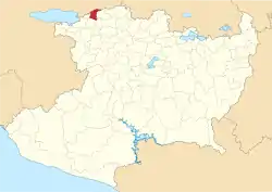
Vista Hermosa (Spanish: "beautiful view") is a municipality in the Mexican state of Michoacán, located approximately 150 kilometres (93 mi) northwest of the state capital of Morelia.
Vista Hermosa | |
|---|---|
 Location of Vista Hermosa in Michoacán | |
 Vista Hermosa Location of Vista Hermosa in Mexico | |
| Coordinates: 20°16′22″N 102°28′50″W[1] | |
| Country | |
| State | |
| Established | 1 December 1921 |
| Seat | Vista Hermosa de Negrete |
| Government | |
| • President | Rosa Elena de la Cruz Pérez Tello |
| Area | |
| • Total | 148.022 km2 (57.152 sq mi) |
| Elevation [1] (of seat) | 1,530 m (5,020 ft) |
| Population (2010 Census)[2] | |
| • Total | 18,995 |
| • Estimate (2015 Intercensal Survey)[3] | 20,624 |
| • Density | 130/km2 (330/sq mi) |
| • Seat | 10,752 |
| Time zone | UTC-6 (Central) |
| • Summer (DST) | UTC-5 (Central) |
| Postal codes | 59200–59220[4] |
| Area code | 328 |
| Website | Official website |
Geography
The municipality of Vista Hermosa is located at an elevation between 1,600 and 1,700 metres (5,200–5,600 ft) in the Bajío region in northwestern Michoacán. It borders the Michoacanese municipalities of Tanhuato to the east, Ixtlán to the southeast, Pajacuarán to the southwest, and Briseñas to the west.[5] Additionally, the Lerma River forms the border between Vista Hermosa and the Jaliscan municipality of La Barca to the north. The municipality covers an area of 148.022 square kilometres (57.152 sq mi)[2] and comprises 0.3% of the state's area.[5]
As of 2009, 91% of the land in Vista Hermosa is used for agriculture and urban areas cover another 4% of the municipality. Vertisols are the main soil type in the municipality.[5] The Duero River flows east to west through the southern part of the municipality, and meets the Lerma River at Ibarra in the adjacent municipality of Briseñas. The Gonzalo Reservoir lies on the border between Tanhuato and Vista Hermosa and has a total capacity of 7,600,000 cubic metres (270,000,000 cu ft) and a useful capacity of 6,600,000 cubic metres (230,000,000 cu ft).[6]
Vista Hermosa has a temperate climate with rain in the summer.[7] Average temperatures in the municipality range between 18 and 20 °C (64–68 °F), and average annual precipitation ranges between 700 and 1,000 millimetres (28–39 in).[5]
History
The settlement of Vista Hermosa was organized in the second half of the 19th century from the haciendas of Buenavista and El Molino. Vista Hermosa was established as a municipality on 1 December 1921 from localities previously part of Ixtlán and Tanhuato. The municipal seat was named Vista Hermosa de Negrete after José María Martínez Negrete, who bought the lands of the Molino hacienda after they were confiscated by the Mexican government and built a school there.[7] In 1950, the municipality of Briseñas was separated from Vista Hermosa.[8]
Administration
The municipal government of Vista Hermosa comprises a president, a councillor (Spanish: síndico), and seven trustees (regidores), four elected by relative majority and three by proportional representation.[7] The current president of the municipality is Rosa Elena de la Cruz Pérez Tello.[9]
Demographics
In the 2010 Mexican Census, the municipality of Vista Hermosa recorded a population of 18,995 inhabitants living in 4789 households.[10] The 2015 Intercensal Survey estimated a population of 20,624 inhabitants in Vista Hermosa.[3]
INEGI lists 16 localities in the municipality,[1] of which two are classified as urban:
- the municipal seat Vista Hermosa de Negrete, which recorded a population of 10,752 inhabitants in the 2010 Census; and
- El Capulín, located 7 kilometres (4.3 mi) south of the municipal seat, which recorded a population of 2438 in 2010.[10]
Economy and infrastructure
Agriculture is the main economic activity in Vista Hermosa. Major crops grown include corn, sorghum, wheat, and vegetables such as chiles.[11] The largest employer in the municipality is the meat producer SuKarne, which maintains a herd of 150,000 cattle in the municipality.[12]
The toll expressway Federal Highway 15D runs through the municipality, as do Federal Highways 35 and 110.
References
- "Sistema Nacional de Información Municipal" (in Spanish). SEGOB. 2010. Retrieved 9 January 2021.
- "Vista Hermosa: Datos generales". Cédulas de información municipal (in Spanish). SEDESOL. 2013. Retrieved 9 January 2021.
- Panorama sociodemográfico de Michoacán de Ocampo 2015 (PDF) (in Spanish). INEGI. 2016. p. 226. ISBN 978-607-739-850-9. Retrieved 9 January 2021.
- "Consulta de Códigos Postales". Catálogo Nacional de Códigos Postales. Mexican Postal Service. 8 January 2021. Retrieved 9 January 2021.
- "Vista Hermosa, Michoacán de Ocampo" (PDF). Prontuario de información geográfica municipal de los Estados Unidos Mexicanos (in Spanish). INEGI. 2009. Retrieved 9 January 2021.
- Anuario estadístico y geográfico de Michoacán de Ocampo 2017 (PDF) (Report) (in Spanish). INEGI. 2017. Table 4.17. Retrieved 9 January 2021.
- "Vista Hermosa". Enciclopedia de los Municipios y Delegaciones de México (in Spanish). INAFED. Retrieved 9 January 2021.
- Estado de Michoacán de Ocampo. División Territorial de 1810 a 1995 (PDF) (in Spanish). Mexico: INEGI. 1996. pp. 68, 91, 226. ISBN 970-13-1501-4.
- Aparicio, Beatriz (25 September 2018). "Configuración política de Michoacán 2018-2021". Alcaldes de México (in Spanish). Retrieved 9 January 2021.
- "Resumen municipal: Municipio de Vista Hermosa". Catálogo de Localidades (in Spanish). SEDESOL. Retrieved 9 January 2021.
- "Yurécuaro, Tanhuato y Vista Hermosa líderes productores de chile en Michoacán". Brunoticias (in Spanish). 16 December 2020. Retrieved 9 January 2021.
- Vista Hermosa Municipal Council (19 February 2019). "Plan de Desarrollo Municipal" (PDF). Periódico Oficial del Estado de Michoacán, 3a. Secc. (in Spanish). Government of Michoacán. p. 4. Retrieved 9 January 2021.
