Vohibinany (district)
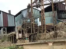
Brickaville District is an administrative district in Atsinanana Region, Madagascar; also known as Ampasimanolotra and Vohibinany. Brickaville is located along Route nationale 2 (RN 2), 105 km south of Toamasina (the primary seaport of the country) and 220 km east of Antananarivo (the capital).[1] It is also situated alongside the Rianila river. It is a railway station on the Antananarivo - East Coast line. Its main industries revolve around sugar.[2]
Brickaville
Ampasimanolotra/Vohibinany | |
|---|---|
 Brickaville | |
 Brickaville Location in Madagascar | |
| Coordinates: 18°49′10″S 49°04′25″E | |
| Country | |
| Region | Tamatave |
| District | Vohibinany (district) |
| Area | |
| • Total | 5,385 km2 (2,079 sq mi) |
| Population | |
| • Total | 190,636 |
| Time zone | UTC3 (EAT) |
Communes
The district is further divided into 17 communes; which are further sub-divided into 180 villages (fokontany):
Economy
The economy is based on agriculture. Lychee, Rice, coconuts and coffee are grown.[3] Since 2019 there is also a graphite mine in Fetraomby, the Sahamamy graphite mine.[4]
Roads
There are two mayor roads: the National Road 2 that leads from the capitol Antananarivo to Toamasina and the National Road 11a that leads from its junction with the national road 2 at Antsampanana south to Vatomandry.
References
- (in French) tourismemada.com Archived June 26, 2012, at the Wayback Machine
- Lonely Planet Madagascar & Comoros, p. 197 (2008)
- Lambahoany
- Agencecofin.com
Capital: Toamasina | ||
| Antanambao Manampotsy - 507 | 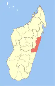 | |
| Mahanoro - 510 | ||
| Marolambo - 513 | ||
| Toamasina I - 501 | ||
| Toamasina II - 502 | ||
| Vatomandry - 517 | ||
| Vohabinany (Brickaville) - 508 | ||
7 districts; 75 communes | ||