Volhynian Governorate
The Volhynian Governorate, Volhynia Governorate or Volyn Governorate[lower-alpha 1] was a province (guberniya) of the Southwestern Krai of the Russian Empire. It consisted of an area of 71,736 square kilometres (27,697 sq mi) and a population of 2,989,482 inhabitants. The governorate bordered the Grodno and Minsk Governorates to the north, the Kiev Governorate to the east, the Podolia Governorate to the south, the Lublin and Siedlce Governorates, and after 1912, the Kholm Governorate and Austria to the west. The administrative centre was Zhitomir (present-day Zhytomyr), until 1804, its administrative centre was located in Novograd-Volynsky (present-day Zviahel). It corresponded to most of Volyn, Rivne and Zhytomyr Oblasts of Ukraine and some parts of Brest and Gomel Regions of Belarus.
Volhynian Governorate
Волынская губернія | |
|---|---|
 Coat of arms | |
.svg.png.webp) Location in the Russian Empire | |
| Country | Russian Empire |
| Krai | Southwestern |
| Established | 1795 |
| Abolished | 1925 |
| Capital |
|
| Area | |
| • Total | 71,736 km2 (27,697 sq mi) |
| Population (1897) | |
| • Total | 2,989,482 |
| • Density | 42/km2 (110/sq mi) |
| • Urban | 7.82% |
| • Rural | 92.18% |
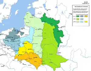
It was created at the end of 1796 after the Third Partition of Poland from the territory of the short-lived Volhynian Vice-royalty and Wołyń Voivodeship. After the Peace of Riga, part of the governorate became the new Wołyń Voivodeship in the Second Polish Republic,[1] while the other part stayed as a part of the Ukrainian SSR until 1925 when it was abolished on resolution of the All-Ukrainian Central Executive Committee and Counsel of People's Commissars.[2]
History
Until 1796 the guberniya was administered as a namestnichestvo (Vice-royalty). It was initially centred in Iziaslav and was called the Izyaslav namesnichestvo. It was created mostly out of the Kiev Voivodeship and the east part of the Wolyn Voivodeship.
On 24 October 1795 the Third Partition of Poland was imposed by Prussia, the Habsburg monarchy, and the Russian Empire.
On 12 December 1796 the Volhynian Governorate (guberniya) was created and included the rest of the Wolyn Voivodeship and Kowel Voivodeship.
In 1796 the administration moved to Novograd-Volynsky, but because no buildings were found suited for administrative purposes the seat (capital) was moved again to Zhytomyr.
In 1802 Zhytomyr was finally bought out of the properties of Prince (knyaz) Ilyinsky and in 1804 it became officially the seat of the Volyn Governorate.
From 1832 to 1915 the Volhynian Governorate and the Kiev Governorate and the Podolia Governorate were part of the Southwestern Krai General-Governorate, a type of militarized administrative-territorial unit.
In the 1880s the general-governorate was extended and included also other governorates.
In 1897 the population of the gubernia was 2,989,482 and in 1905 – 3,920,400. The majority of the population of the governorate spoke in Ukrainian language with slight variety of dialects.
During the Ukrainian–Soviet War Zhytomir served as the provisional capital of Ukraine in 1918.
After the Polish-Soviet war in 1920 and according to the Peace of Riga (1921) most of the territory became part of the Second Polish Republic and transformed into Wołyń Voivodeship with the capital in Łuck (Lutsk). The eastern portion existed to 1925 and later split into three okruhas Shepetivka Okruha, Zhytomyr Okruha, and Korosten Okruha.
Heads of Guberniya
- Revkom
- 1919 Mikhail Kruchinskiy (concurrently the head of Volyn Cheka)
- Volyn Executive Committee
- 1920 Oleksandr Shumsky
- 1920 Vasiliy Averin
- – 1921 Danylevych
- 1921–1922 Ivan Nikolayenko
Head of Security Services
- Cheka
- 1919 Vasyl Viliavko
- 1919 M.Shuf
- 1919 Mikhail Kruchinskiy
- November 1919 – December 1919 Vsevolod Balytsky
- December 1919 Vasyl Levotsky (acting)
- – 2 November 1921 Semen Kesselman (Zapadny)
- January 1922 – 2 June 1922 Janis Biksons
- GPU
- -1923 Pavel Ivonin
- March 1923 – October 1923 Foma Leoniuk
- 1 July 1923 – 1 September 1924 Symon Dukelsky
- 1924 – 1925 Aleksandr Safes (Grozny)
Principal cities
Russian Census of 1897
- Zhytomir – 65 895 (Jewish – 30 572, Russian – 16 944, Ukrainian – 9 152)
- Rovno – 24 573 (Jewish – 13 704, Russian – 4 278, Ukrainian – 4 071)
- Kremenets – 17 704 (Ukrainian – 8 322, Jewish – 6 476, Russian – 1 863)
- Kovel – 17 697 (Jewish – 8 502, Russian – 4 828, Ukrainian – 2 093)
- Novograd-Volynsky – 16 904 (Jewish – 9 363, Russian – 2 939, Ukrainian – 2 662)
- Starokonstantinov – 16 377 (Jewish – 9 164, Ukrainian – 4 886, Russian – 1 402)
- Lutsk – 15 804 (Jewish – 9 396, Russian – 2 830, Ukrainian – 1 478)
- Ostrog – 14 749 (Jewish – 9 185, Ukrainian – 2 446, Russian – 2 199)
- Dubno – 14 257 (Jewish – 7 096, Russian – 2 962, Ukrainian – 2 474)
- Zaslavl – 12 611 (Jewish – 5 991, Ukrainian – 3 990, Russian – 1 722)
Administrative division
| County | Capital | Arms of capital | Area | Population (1897 census) | |
|---|---|---|---|---|---|
| Transliteration name | Russian Cyrillic | ||||
| Vladimir-Volynsky | Владиміро-Волынскій | Vladimir-Volynsky | 6,482.1 km2 (2,502.8 sq mi) | 198,688 | |
| Dubensky | Дубенскій | Dubno | 3,963.8 km2 (1,530.4 sq mi) | 158,734 | |
| Zhitomirsky | Житомірскій | Zhitomir | 7,670.5 km2 (2,961.6 sq mi) | 281,387 | |
| Zaslavsky | Заславскій | Zaslavl | 3,476.7 km2 (1,342.4 sq mi) | 93,381 | |
| Kovelsky | Ковельскій | Kovel | 7,656.8 km2 (2,956.3 sq mi) | 121,326 | |
| Kremenetsky | Кременецкій | Kremenets | 3,460.8 km2 (1,336.2 sq mi) | 196,751 | |
| Lutsky | Луцкій | Lutsk | 7,540.8 km2 (2,911.5 sq mi) | 203,761 | |
| Novograd-Volynsky | Новоградъ-Волынскій | Novograd-Volynsky | 7,205 km2 (2,782 sq mi) | 273,123 | |
| Ovruchsky | Овручскій | Ovruch | 10,616.9 km2 (4,099.2 sq mi) | 194,796 | |
| Ostrozhsky | Острожскій | Ostrog | 3,065.9 km2 (1,183.8 sq mi) | 166,882 | |
| Rovensky | Ровенскій | Rovno | 8,568.4 km2 (3,308.3 sq mi) | 275,119 | |
| Starokonstantinovsky | Староконстантиновскій | Starokostiantinov | 2,560.4 km2 (988.6 sq mi) | 211,768 | |
Demographics
Language
According to the Russian Empire Census on 28 January [O.S. 1897] 15 January, the Volhynian Governorate had a population of 2,982,482, including 1,502,803 men and 1,486,679 women. The majority of the population indicated Little Russian[lower-alpha 2] to be their mother tongue, with significant Jewish, Polish, German, and Russian speaking minorities.[5]
| Language | Native speakers | Percentage |
|---|---|---|
| Ukrainian[lower-alpha 2] | 2,095,537 | 70.26 |
| Jewish | 394,774 | 13.24 |
| Polish | 184,161 | 6.17 |
| German | 171,331 | 5.74 |
| Russian[lower-alpha 2] | 104,889 | 3.52 |
| Czech | 27,670 | 0.93 |
| Tatar | 3,817 | 0.13 |
| Belarusian[lower-alpha 2] | 3,794 | 0.13 |
| Bashkir | 983 | 0.03 |
| Mordovian | 375 | 0.01 |
| Romanian | 314 | 0.01 |
| Chuvash | 308 | 0.01 |
| Gypsi | 286 | 0.01 |
| French | 154 | 0.00 |
| Cheremis | 143 | 0.00 |
| Latvian | 113 | 0.00 |
| Lithuanian | 103 | 0.00 |
| Votyak | 102 | 0.00 |
| Not-specified | 97 | 0.00 |
| Others | 531 | 0.01 |
| Total | 2,982,482 | 100.00 |
Religion
- By the Imperial census of 1897.[6] In bold are religions with more members than the Eastern Orthodox.
| Religion | Number | percentage (%) | males | females |
|---|---|---|---|---|
| Eastern Orthodox | 2,106,521 | 70.46 | ||
| Judaism | 395,782 | 13.24 | ||
| Roman Catholics | 298,110 | 9.97 | ||
| Lutherans | 163,990 | 5.49 | ||
| Baptists | 10 375 | 0.35 | ||
| Other[7] (Old Believers, Magometians) | 14 704 | 0.49 |
Notes
- Prior to 1918, the Imperial Russian government classified Russians as the Great Russians, Ukrainians as the Little Russians, and Belarusians as the White Russians. After the creation of the Ukrainian People's Republic in 1918, the Little Russians identified themselves as "Ukrainian".[3] Also, the Belarusian Democratic Republic which the White Russians identified themselves as "Belarusian".[4]
References
- Eberhardt, Piotr; Jan Owsinski (2003). Ethnic Groups and Population Changes in Twentieth-Century Central-Eastern Europe: History, Data, Analysis. M.E. Sharpe. p. 260. ISBN 0-7656-0665-8.
- Vermenych, Ya Volhynian Governorate (Волинська губернія). Encyclopedia of History of Ukraine.
- Hamm, Michael F. (2014). Kiev: A Portrait, 1800–1917. Princeton University Press. p. 83. ISBN 978-1-4008-5151-5.
- Fortson IV, Benjamin W. (2011). Indo-European Language and Culture: An Introduction. John Wiley & Sons. p. 429. ISBN 978-1-4443-5968-8.
- Первая всеобщая перепись населения Российской Империи 1897 г. [The first general census of the population of the Russian Empire in 1897]. www.demoscope.ru (in Russian). Retrieved 1 May 2023.
- Religion Statistics of 1897 (in Russian)
- Religions, number of believers which in all gubernia were less than 10000