Volkel
Volkel (Brabantian: Vollekul) is a village in the Netherlands. It is situated in the north-east corner of the province of North Brabant, south-east of the town of Uden. On 1 January 2021, Volkel had 3,435 inhabitants. It used to be part of the municipality of Uden, and merged into the municipality of Maashorst in 2022.[3]
Volkel | |
|---|---|
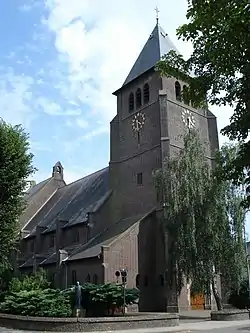 Church of St. Anthony | |
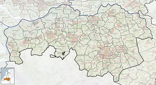 Volkel Location in the province of North Brabant in the Netherlands  Volkel Volkel (Netherlands) | |
| Coordinates: 51°38′40″N 5°39′10″E | |
| Country | Netherlands |
| Province | North Brabant |
| Municipality | Maashorst |
| Area | |
| • Total | 16.58 km2 (6.40 sq mi) |
| Elevation | 19 m (62 ft) |
| Population (2021)[1] | |
| • Total | 3,435 |
| • Density | 210/km2 (540/sq mi) |
| Time zone | UTC+1 (CET) |
| • Summer (DST) | UTC+2 (CEST) |
| Postal code | 5408[1] |
| Dialing code | 0413 |
Volkel is known for Volkel Air Base and amusement park BillyBird Park Hemelrijk.
Volkel used to be a little village. In 1455, a chapel was built, but did not get a church until 1855.[4] In 1940, a military airport was built near Volkel by the Germans. During Operation Market Garden, the airport was bombed many times. The damage was repaired afterwards, and it first served as an Allied airport and later it became a Dutch military airport.[3]
Gallery
%252C_Alphajet%252C_Patrouille_de_France_P1010341_(50852713981).jpg.webp) Patrouille de France at Volkel Air Base
Patrouille de France at Volkel Air Base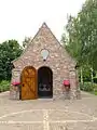 Chapel
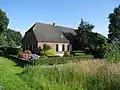 Farm in Volkel
 Clergy house
Climate
| Climate data for Volkel (1991−2020 normals, extremes 1951−present) | |||||||||||||
|---|---|---|---|---|---|---|---|---|---|---|---|---|---|
| Month | Jan | Feb | Mar | Apr | May | Jun | Jul | Aug | Sep | Oct | Nov | Dec | Year |
| Record high °C (°F) | 15.0 (59.0) |
19.8 (67.6) |
25.4 (77.7) |
30.5 (86.9) |
33.5 (92.3) |
36.3 (97.3) |
40.1 (104.2) |
36.6 (97.9) |
33.5 (92.3) |
27.5 (81.5) |
20.0 (68.0) |
16.0 (60.8) |
40.1 (104.2) |
| Average high °C (°F) | 5.9 (42.6) |
7.0 (44.6) |
10.8 (51.4) |
15.3 (59.5) |
19.1 (66.4) |
21.9 (71.4) |
24.0 (75.2) |
23.7 (74.7) |
19.9 (67.8) |
14.9 (58.8) |
9.8 (49.6) |
6.4 (43.5) |
14.9 (58.8) |
| Daily mean °C (°F) | 3.2 (37.8) |
3.6 (38.5) |
6.3 (43.3) |
9.9 (49.8) |
13.6 (56.5) |
16.5 (61.7) |
18.5 (65.3) |
18.0 (64.4) |
14.7 (58.5) |
10.7 (51.3) |
6.7 (44.1) |
3.9 (39.0) |
10.5 (50.9) |
| Average low °C (°F) | 0.1 (32.2) |
0.1 (32.2) |
1.8 (35.2) |
4.0 (39.2) |
7.6 (45.7) |
10.5 (50.9) |
12.6 (54.7) |
12.1 (53.8) |
9.5 (49.1) |
6.5 (43.7) |
3.3 (37.9) |
0.9 (33.6) |
5.8 (42.4) |
| Record low °C (°F) | −20.1 (−4.2) |
−25.2 (−13.4) |
−13.7 (7.3) |
−7.4 (18.7) |
−2.1 (28.2) |
0.1 (32.2) |
2.7 (36.9) |
2.7 (36.9) |
−0.9 (30.4) |
−6.2 (20.8) |
−10.0 (14.0) |
−18.8 (−1.8) |
−25.2 (−13.4) |
| Average precipitation mm (inches) | 64.0 (2.52) |
58.2 (2.29) |
52.7 (2.07) |
40.4 (1.59) |
57.6 (2.27) |
64.1 (2.52) |
70.6 (2.78) |
73.4 (2.89) |
59.4 (2.34) |
61.8 (2.43) |
64.8 (2.55) |
72.2 (2.84) |
739.2 (29.10) |
| Average relative humidity (%) | 87.5 | 84.7 | 79.5 | 73.3 | 72.9 | 74.2 | 75.4 | 77.6 | 82.2 | 86.1 | 89.9 | 89.8 | 81.1 |
| Mean monthly sunshine hours | 69.2 | 90.7 | 143.3 | 190.2 | 217.4 | 211.8 | 215.4 | 198.9 | 158.2 | 121.8 | 72.9 | 56.1 | 1,745.9 |
| Percent possible sunshine | 26.6 | 32.2 | 38.8 | 45.8 | 44.9 | 42.6 | 43.0 | 43.8 | 41.6 | 36.8 | 27.2 | 22.9 | 37.2 |
| Source: Royal Netherlands Meteorological Institute[5][6] | |||||||||||||
References
- "Kerncijfers wijken en buurten 2021". Central Bureau of Statistics. Retrieved 17 April 2022.
- "Postcodetool for 5408AA". Actueel Hoogtebestand Nederland (in Dutch). Het Waterschapshuis. 24 July 2019. Retrieved 17 April 2022.
- "Volkel". Plaatsengids (in Dutch). Retrieved 17 April 2022.
- Chris Kolman & Ronald Stenvert (1997). Volkel (in Dutch). Zwolle: Waanders. ISBN 90-400-9945-6. Retrieved 16 April 2022.
- "Weerstatistieken Volkel". Royal Netherlands Meteorological Institute. Retrieved July 3, 2022.
- "Klimaatviewer 1991-2020". Royal Netherlands Meteorological Institute. Retrieved July 3, 2022.