Wassertrüdingen
Wassertrüdingen is a town in the district of Ansbach, Middle Franconia, Bavaria, Germany. It is between the Hesselberg, the only Franconian mountain with a view on the Alps, the wooded heights of the Oettinger Forest and the foothills of the Hahnenkamm. The Fränkisches Seenland (Franconian Lake District) recreation area is 15 kilometers away. Altentrüdingen, Fürnheim, Geilsheim, Obermögersheim, Reichenbach und Schobdach are part of Wassertrüdingen
Wassertrüdingen | |
|---|---|
 Coat of arms | |
Location of Wassertrüdingen within Ansbach district  | |
 Wassertrüdingen 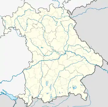 Wassertrüdingen | |
| Coordinates: 49°2′N 10°36′E | |
| Country | Germany |
| State | Bavaria |
| Admin. region | Mittelfranken |
| District | Ansbach |
| Subdivisions | 6 Ortsteile |
| Government | |
| • Mayor (2018–24) | Stefan Ultsch[1] (SPD) |
| Area | |
| • Total | 53.58 km2 (20.69 sq mi) |
| Elevation | 423 m (1,388 ft) |
| Population (2022-12-31)[2] | |
| • Total | 6,309 |
| • Density | 120/km2 (300/sq mi) |
| Time zone | UTC+01:00 (CET) |
| • Summer (DST) | UTC+02:00 (CEST) |
| Postal codes | 91717 |
| Dialling codes | 0 98 32 |
| Vehicle registration | AN |
| Website | www.wassertruedingen.de |
First documentary evidence in 836 is as truth muntiga. In 1524 Wassertrüdingen was occupied by peasants during the German Peasants' War. During the Thirty Years' War it was severely damaged and had not fully recovered yet 150 years later. In the last weeks of the Second World War the train station was bombarded.
People
- Christian Friedrich Freyer (1794-1885), German entomologist
- Johannes Seidlitz (born 1990), German racing driver
References
- Liste der ersten Bürgermeister/Oberbürgermeister in kreisangehörigen Gemeinden, Bayerisches Landesamt für Statistik, accessed 19 July 2021.
- Genesis Online-Datenbank des Bayerischen Landesamtes für Statistik Tabelle 12411-003r Fortschreibung des Bevölkerungsstandes: Gemeinden, Stichtag (Einwohnerzahlen auf Grundlage des Zensus 2011)
External links
- http://wassertrüdingen.de the official website of Wassertrüdingen. In German