Wellington Square, North Adelaide
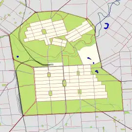
Wellington Square, also known as Kudnartu (and formerly Kudnarto), is a public square in the Adelaide suburb of North Adelaide, South Australia, in the City of Adelaide. It is roughly at the centre of the largest of the three grids which comprise North Adelaide.
| Wellington Square | |
|---|---|
| Kudnartu | |
 | |
 | |
| Type | Square |
| Location | North Adelaide, South Australia |
| Coordinates | 34°54′26″S 138°35′29″E |
| Created | 1837 |
It is one of six squares designed by the founder of Adelaide, Colonel William Light, who was Surveyor-General at the time, in his 1837 plan of the Adelaide city centre and North Adelaide. The square was named in 1837 by the Street Naming Committee after the Duke of Wellington, and in 2003 it was assigned a second name, Kudnartu, in the Kaurna language of the original inhabitants, as part of the Adelaide City Council's dual naming initiative. Kudnartu was a Kaurna woman from the Clare District. Hers was the first official Aboriginal/settler marriage in South Australia.[lower-alpha 1][1]
History
Pre-colonial history
The Adelaide area was inhabited long before European settlement in 1836 by one of the tribes which later came to be known as the Kaurna people, or Adelaide tribe.[2]
As Wellington Square
The square was named on 23 May 1837 after Arthur Wellesley, 1st Duke of Wellington, Irish-born field marshal and statesman, victor at Waterloo and Prime Minister of the United Kingdom from 1828 to 1830,[3] who is credited with securing the passage of the South Australia Foundation Act through the British House of Lords in 1834.[4] Colonel Light, first Surveyor-General of South Australia and a member of the Street Naming Committee, had briefly served under Wellington as a junior staff officer,[5] a Deputy Assistant Quartermaster General (DAQMG), during the Peninsular War. Light's 1837 plan of Adelaide included Wellington Square.[6]
Dual naming
In March 2003, as part of the City of Adelaide's dual naming project in association with the University of Adelaide, the square was assigned the name "Kudnartu",[7][8] to commemorate a Kaurna woman from the Clare District (Crystal Brook area) called Kudnartu, also spelt Kudnarto,[1] who married a settler, a shepherd named Tom Adams, in January 1848 at the Registry Office in Waymouth Street.[3] This was the first recorded official Aboriginal/settler marriage in South Australia.[9]
The name Kudnartu/Kudnarto means "third born if female".[10] Also known as Mary Ann Adams, Kurdnatu had attended the "Native Establishment School" (later re-purposed as the Destitute Asylum) in Kintore Avenue, Adelaide, to learn "the arts of domestic life and household duties", and subsequently taught the illiterate Adams to write. They had two sons, Tom (born 1849) and Tim (1852), but they and their father were left destitute after Kudnartu's death at about 23 years old, around 1855, after land allocated to Kudnarto was repossessed by the government. Kudnarto continues to have many descendants.[11] [3]
Today
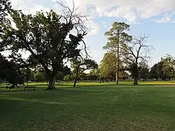
Wellington Square is one of only two of Light's six squares, Whitmore Square being the other one, which still retain the original configuration, neither having been dissected by roads like the others.[12] The square has jacaranda trees, roses, and cherry trees, and the walking trail around the perimeter is about 700 metres (770 yd).[3]
Further reading
- Woerlee, Bill. "Kudnarto". Kudnarto.
Notes and references
- Spelled "Konarto" in the Register of Births, Deaths & Marriage, Book 1, page 333
- "Easy walking trail in Wellington Square/Kudnartu". City of Adelaide. 12 May 2019.
- "Kaurna People". Adelaidia. 20 March 2017. Retrieved 1 July 2019.
- "Walking Trail Wellington Square/Kudnartu" (PDF). Information as supplied by Dr. Robert Amery, 1997. City of Adelaide. Retrieved 7 December 2019.
{{cite web}}: CS1 maint: others (link) - "History of Adelaide Through Street Names". History of South Australia website. Archived from the original on 14 June 2008. Retrieved 25 July 2008.
- "Light, William (1786–1839)". Australian Dictionary of Biography online. National Centre of Biography, Australian National University. Retrieved 25 July 2008.
- Margaret Anderson (31 December 2013). "Light's Plan of Adelaide 1837". adelaidia.sa.gov.au. History SA. Retrieved 5 May 2018.Copy of William Light's Plan of Adelaide, 1837, Held by the History Trust of South Australia, HT2001.166, adelaidia.sa.gov.au
- "Kaurna Placename Meanings within the City of Adelaide". University of Adelaide. Kaurna Warra Pintyanthi. 27 November 2019.
- Note: Pronunciation can be listened to here
- "City squares recognise women from the past". City of Adelaide. 19 March 2018.
- Amery, Rob; Williams, Georgina Yambo (March 2009). "[Chapter] 18. Reclaiming Through Renaming: The Reinstatement of Kaurna Toponyms in Adelaide and the Adelaide Plains" (PDF). In: The Land is a Map: Placenames of Indigenous Origin in Australia], edited by Luise Anna Hercus, Jane Helen Simpson, and Flavia Hodges. (Pandanus Books, 2002) pp.255-276. doi:10.22459/LM.03.2009.18.
{{cite journal}}: Cite journal requires|journal=(help) Austlit entry - "Biography - Kudnarto". Indigenous Australia,'Kudnarto (c. 1832–1855)', Australian Dictionary of Biography, National Centre of Biography, Australian National University, by Peggy Brock.
- Clark, Amber; Ramm, Kara-Lee; McInnes, Simone; Elton, Jude. "Whitmore Square, SA History Hub". History SA. Retrieved 6 December 2019.