Wenum-Wiesel
Wenum-Wiesel is a twin village in the municipality of Apeldoorn, in the province of Gelderland in the Netherlands. In 1978, the hamlets of Wenum and Wiesel merged into a village.
Wenum-Wiesel | |
|---|---|
Twin village | |
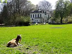 Estate "De Ploeg" | |
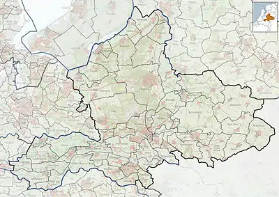 Wenum-Wiesel Location in the province of Gelderland  Wenum-Wiesel Wenum-Wiesel (Netherlands) | |
| Coordinates: 52.2537°N 5.9542°E | |
| Country | Netherlands |
| Province | Gelderland |
| Municipality | Apeldoorn |
| Area | |
| • Total | 30.65 km2 (11.83 sq mi) |
| Elevation | 16 m (52 ft) |
| Population (2021)[1] | |
| • Total | 2,170 |
| • Density | 71/km2 (180/sq mi) |
| Time zone | UTC+1 (CET) |
| • Summer (DST) | UTC+2 (CEST) |
| Postal code | 7345[1] |
| Dialing code | 055 |
History
Wenum was first attested in 1335 as "in der Merck to Wenen",[3] however the watermill was already mentioned in 1313.[4] The etymology of the name is unclear.[3] Wiesel was first attested in 1337 as Wiessel, and means pasture near a forest.[5]
In 1684, William III of Orange bought approximately 100 square kilometres (39 sq mi) of forest and heath in the area as a crown land. The land included the village of Wiesel. He intended to build his palace in Hoog Soeren, but changed his mind and bought Het Loo Palace in Apeldoorn.[6][7] In 1840, Wenum was home to 256 people, and Wiesel to 243 people.[8]
In 1876, the Amsterdam–Zutphen railway was completed, and William III of the Netherlands wanted a side track to his palace. In 1887, the Apeldoorn–Zwolle railway line was completed and partially used the side track. A railway stop was constructed at Wenum. The station closed in 1938.[9][10] In 1840, the gristmill Grondzeiler Wenum was built in Wenum. The current windmill dates from 1913.[11]
In 1978, the hamlets of Wenum and Wiesel merged into the twin village Wenum-Wiesel. The hamlets are still somewhat separated. The place name signs are chaotic and sometimes use the combined name, or the individual hamlet. The village has a combined school, and village council.[8]
Gallery
![Windmill Grondzeiler Wenum [nl]](../I/Wenum_Wenumermolen_05.JPG.webp) Windmill Grondzeiler Wenum
Windmill Grondzeiler Wenum_-_Wenum_-_20253450_-_RCE.jpg.webp) Klein Cannenburgh
Klein Cannenburgh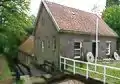 Watermill of Wenum
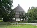 Farm in Wenum
References
- "Kerncijfers wijken en buurten 2021". Central Bureau of Statistics. Retrieved 19 March 2022.
The hamlet Beemte-Broekland (1,035 inhabitants - 12.79 km2) has been subtracted from the total
- "Postcodetool for 7345AA". Actueel Hoogtebestand Nederland (in Dutch). Het Waterschapshuis. Retrieved 19 March 2022.
- "Wenum - (geografische naam)". Etymologiebank (in Dutch). Retrieved 19 March 2022.
- Ronald Stenvert & Sabine Broekhoven (2000). "Apeldoorn" (in Dutch). Zwolle: Waanders. p. 78. ISBN 90 400 9406 3. Retrieved 19 March 2022.
- "Wiesel - (geografische naam)". Etymologiebank (in Dutch). Retrieved 19 March 2022.
- "Hoog Soeren - (geografische naam)". Etymologiebank (in Dutch). Retrieved 19 March 2022.
- "Wieselsche bosch (Kroondomein)" (PDF). IVN Apeldoorn (in Dutch). Retrieved 19 March 2022.
- "Wenum-Wiesel". Plaatsengids (in Dutch). Retrieved 19 March 2022.
- "Trein". Gelderland Binnenste Buiten (in Dutch). Archived from the original on 7 April 2014. Retrieved 19 March 2022.
- "Station Wenum". Stationsweb (in Dutch). Retrieved 19 March 2022.
- "Wenum, Gelderland". Molendatabase (in Dutch). Retrieved 19 March 2022.