Essequibo Islands-West Demerara
Essequibo Islands-West Demerara (Region 3) is a region of Guyana.
Essequibo Islands-West Demerara
Region 3 | |
|---|---|
Administrative Region | |
 Arrowpoint | |
.svg.png.webp) Flag | |
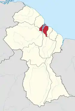 Map of Guyana showing Essequibo Islands-West Demerara region | |
| Country | |
| Regional Capital | Vreed-en-Hoop |
| Area | |
| • Total | 3,755 km2 (1,450 sq mi) |
| Population (2012 census) | |
| • Total | 107,416 |
| • Density | 29/km2 (74/sq mi) |
| [1] | |
Split in two by the Essequibo River, Venezuela claims the territory to the west of Essequibo river as part of Delta Amacuro state, which represents the Essequibo Islands. West Demerara, located east of Essequibo river, is out of the dispute.
It is bordered by the Atlantic Ocean to the north, the region of Demerara-Mahaica and Demerara River to the east, the region of Upper Demerara-Berbice to the south and the region of Pomeroon-Supenaam to the west. It contains villages such as Parika, Tuschen and Uitvlugt. It contains the three hundred and sixty five islands in the Essequibo river[2] of which three of the largest islands can be found at the mouth of the Essequibo, these are Hogg Island, Wakenaam and Leguan.
Population
The Government of Guyana has administered three official censuses since the 1980 administrative reforms, in 1980, 1991 and 2002.[3] In 2002, the population of Essequibo Islands-West Demerara was recorded at 103,061 people.[4] Official census records for the population of Essequibo Islands-West Demerara are as follows:
- 2012: 107,416
- 2002: 103,061
- 1991: 95,975
- 1980: 104,750
Communities
(including name variants):[5]
- Ampa Bay (Post Ampa)
- Anna Catherina
- Caledonia
- Cornelia Ida
- De Jonge Rachael
- De Willem
- Den Amstel (Den Amstel Village, Amstel)
- Fort Island
- Fredericksburg
- Goed Fortuin
- Hague Backdam (Hague Front/Jib, Hague)
- Harlem
- Hogg Island
- Hopetown
- Hubu
- La Parfaite Harmonie
- Leonora
- Louisiana
- Makouria
- McDoom Village (McDoom)
- Met-en-Meerzorg (Meten-Meer-Zorg)
- Melville
- Morasi
- Nismes
- Noitgedacht
- Parika
- Patentia
- Phoenix Town
- Ruimzight
- Santa Mission (Santa Aratak)
- Sarah
- Saxacalli (Saxakalli, Saxsacali)
- Schoonord (SchoonordSchoon Ord)
- Stanleytown
- Stewartville
- Tuschen
- Uitvlugt
- Vergenoegen
- Vreed-en-Hoop
- Vriesland
- vive-la-force,Guyana
- Windsor Forest
- Zeeburg
- Zeelandia
Gallery
.jpg.webp) Coconut grove on Wakenaam Island, Essequibo River
Coconut grove on Wakenaam Island, Essequibo River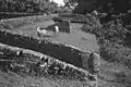 Ruins of Fort Zeelandia on Fort Island, Essequibo River
.jpg.webp) Parika on the east bank of the Essequibo River
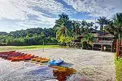
Parika on the east bank of the Essequibo River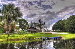 Santa Mission a nature reserve
.jpg.webp) Trail in Wakenaam
Trail in Wakenaam
See also
References
- Macmillan Publishers (2009). "Administrative Regions - 2 and 3". Macmillan Junior Atlas: Guyana. Oxford: Macmillan Caribbean. p. 34. ISBN 9780333934173.
- "Home Affairs Minister visits several Essequibo Islands". Guyana Chronicle. Retrieved 26 August 2020.
- Beaie, Sonkarley Tiatun (19 September 2007). "Chapter 3: National Redistribution and Internal Migration" (PDF). 2002 Population and Housing Census - Guyana National Report. Bureau of Statistics. p. 51. Archived from the original (PDF) on 17 February 2012. Retrieved 29 August 2012.
- Beaie, Sonkarley Tiatun (19 September 2007). "National Population Trends: Size, Growth and Distribution" (PDF Download). 2002 Population and Housing Census - Guyana National Report. Bureau of Statistics. p. 25. Retrieved 29 August 2012.
- "2012 Population by Village". Statistics Guyana. Retrieved 8 December 2021.