East Fork Williams Fork
The East Fork Williams Fork is a tributary of the Williams Fork in north central Colorado in the United States. The river merges with the South Fork Williams Fork to form the Williams Fork.[2] Perhaps the most unusual river name in Colorado is the West Fork East Fork Williams Fork, a tributary of the East Fork Williams Fork.
| East Fork Williams Fork[1] | |
|---|---|
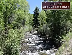 The river just before it goes under County Road 8 in the Routt National Forest | |
| Physical characteristics | |
| Source | |
| • location | Devils Causeway |
| • coordinates | 40°02′27″N 107°09′50″W[1] |
| Mouth | |
• location | Confluence with South Fork Williams Fork |
• coordinates | 40°19′05″N 107°24′39″W[1] |
• elevation | 6,558 feet (1,999 meters)[1] |
| Basin features | |
| Progression | Williams Fork—Yampa—Green—Colorado |
| Tributaries | |
| • left |
|
| • right |
|
See also
References
- "East Fork Williams Fork". Geographic Names Information System. United States Geological Survey, United States Department of the Interior. Retrieved 2021-06-25.
- "Stream Trace Summary Report". USGS Streamer. United States Geological Survey. 2021-06-25. Retrieved 2021-06-25.
This article is issued from Wikipedia. The text is licensed under Creative Commons - Attribution - Sharealike. Additional terms may apply for the media files.