Western Heights, Auckland
Western Heights is a neighbourhood of Henderson, in West Auckland, New Zealand. Western Heights School and the nearby shops are the centre of the community. Western Heights is a "frontier suburb", separating suburban Auckland from lifestyle farming blocks, orchards and the Waitākere Ranges.
Western Heights | |
|---|---|
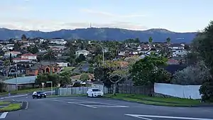 View from Palomino Drive, looking toward the Waitākere Ranges | |
| Coordinates: 36°52′59″S 174°36′54″E | |
| Country | New Zealand |
| City | Auckland |
| Local authority | Auckland Council |
| Electoral ward | Waitākere Ward |
| Local board | Henderson-Massey |
| Area | |
| • Land | 354 ha (875 acres) |
| Population (June 2023)[2] | |
| • Total | 9,900 |
| Rānui | Lincoln | |
|
|
Henderson | |
| Henderson Valley | McLaren Park | Sunnyvale |
History
In the 1920s, the area was sparsely populated. The Sturges Road area was home to orchards, primarily grown by immigrant families from Dalmatia.[3]
Demographics
Western Heights covers 3.54 km2 (1.37 sq mi)[1] and had an estimated population of 9,900 as of June 2023,[2] with a population density of 2,797 people per km2.
| Year | Pop. | ±% p.a. |
|---|---|---|
| 2006 | 7,956 | — |
| 2013 | 9,333 | +2.31% |
| 2018 | 10,272 | +1.94% |
| Source: [4] | ||
Western Heights had a population of 10,272 at the 2018 New Zealand census, an increase of 939 people (10.1%) since the 2013 census, and an increase of 2,316 people (29.1%) since the 2006 census. There were 3,015 households, comprising 5,061 males and 5,211 females, giving a sex ratio of 0.97 males per female, with 2,016 people (19.6%) aged under 15 years, 2,193 (21.3%) aged 15 to 29, 4,842 (47.1%) aged 30 to 64, and 1,233 (12.0%) aged 65 or older.
Ethnicities were 46.8% European/Pākehā, 8.6% Māori, 9.1% Pacific peoples, 42.8% Asian, and 4.3% other ethnicities. People may identify with more than one ethnicity.
The percentage of people born overseas was 46.5, compared with 27.1% nationally.
Although some people chose not to answer the census's question about religious affiliation, 40.3% had no religion, 37.1% were Christian, 0.4% had Māori religious beliefs, 8.2% were Hindu, 3.9% were Muslim, 2.0% were Buddhist and 2.4% had other religions.
Of those at least 15 years old, 2,298 (27.8%) people had a bachelor's or higher degree, and 1,161 (14.1%) people had no formal qualifications. 1,560 people (18.9%) earned over $70,000 compared to 17.2% nationally. The employment status of those at least 15 was that 4,473 (54.2%) people were employed full-time, 1,026 (12.4%) were part-time, and 297 (3.6%) were unemployed.[4]
| Name | Area (km2) | Population | Density (per km2) | Households | Median age | Median income |
|---|---|---|---|---|---|---|
| Summerland South | 1.33 | 3,213 | 2,416 | 933 | 36.9 years | $34,200[5] |
| Summerland North | 0.85 | 2,580 | 3,035 | 801 | 37.4 years | $35,800[6] |
| Western Heights (Auckland) | 1.36 | 4,479 | 3,293 | 1,281 | 34.8 years | $36,300[7] |
| New Zealand | 37.4 years | $31,800 |
Education
Western Heights School and Summerland Primary are coeducational contributing primary (years 1–6) schools with rolls of 636 and 588 respectively, as of April 2023.[8][9][10] Summerland Primary opened in 2002. The area is named for the summerland apple variety once grown there.[11]
The local State secondary schools are Henderson High School, Waitakere College, Massey High School, Liston College and St Dominic's College.
References
- "ArcGIS Web Application". statsnz.maps.arcgis.com. Retrieved 26 June 2022.
- "Population estimate tables - NZ.Stat". Statistics New Zealand. Retrieved 25 October 2023.
- Flude, Anthony G. (2008). Henderson's Mill: a history of Henderson 1849-1939. West Auckland Historical Society. pp. 77–80. ISBN 9781877431210.
- "Statistical area 1 dataset for 2018 Census". Statistics New Zealand. March 2020. Summerland South (126000), Summerland North (126100) and Western Heights (Auckland) (126900).
- 2018 Census place summary: Summerland South
- 2018 Census place summary: Summerland North
- 2018 Census place summary: Western Heights (Auckland)
- "New Zealand Schools Directory". New Zealand Ministry of Education. Retrieved 12 December 2022.
- Education Counts: Western Heights School
- Education Counts: Summerland Primary School
- "Summerland Primary's History". Retrieved 26 June 2020.
External links
- Photographs of Western Heights held in Auckland Libraries' heritage collections.