Willisau District
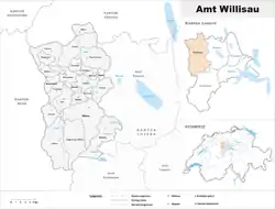
Willisau District is one of the five districts (German: Ämter) of the German-speaking Canton of Lucerne, Switzerland. Its capital is the town of Willisau. It has a population of 55,079 (as of 31 December 2020). In 2013 its name was changed from Amt Willisau to Wahlkreis Willisau as part of a reorganization of the canton. A sixth Wahlkreis was created, but in Willisau everything else remained essentially unchanged.
Willisau District
Wahlkreis Willisau | |
|---|---|
District | |
 | |
| Country | |
| Canton | |
| Capital | Willisau |
| Area | |
| • Total | 336.99 km2 (130.11 sq mi) |
| Population (2020) | |
| • Total | 55,079 |
| • Density | 160/km2 (420/sq mi) |
| Time zone | UTC+1 (CET) |
| • Summer (DST) | UTC+2 (CEST) |
| Municipalities | 21 |
Willisau District consists of the following municipalities:
| Municipality | Population (31 December 2020)[1] |
Area, km² |
|---|---|---|
| Alberswil | 665 | 3.6 |
| Altbüron | 1,017 | 6.8 |
| Altishofen | 1,959 | 5.7 |
| Dagmersellen | 5,680 | 23.9 |
| Egolzwil | 1,530 | 4.2 |
| Ettiswil | 2,792 | 12.5 |
| Fischbach | 702 | 8.1 |
| Grossdietwil | 855 | 10.2 |
| Hergiswil bei Willisau | 1,908 | 31.3 |
| Luthern | 1,245 | 37.9 |
| Menznau | 2,966 | 30.4 |
| Nebikon | 2,713 | 3.7 |
| Pfaffnau | 2,674 | 17.6 |
| Reiden | 7,255 | 27.0 |
| Roggliswil | 723 | 6.2 |
| Schötz | 4,575 | 15.27 |
| Ufhusen | 927 | 12.3 |
| Wauwil | 2,380 | 2.9 |
| Wikon | 1,495 | 8.3 |
| Willisau | 7,752 | 47.22 |
| Zell | 2,108 | 13.9 |
| Total | 55,079 | 336.99[2]a |
- ^a 1992/97 survey gives a total area of 337.45 km2 (130.29 sq mi) without including certain large lakes, while the 2000 survey includes lakes but due to other changes is slightly lower.
Mergers
- On 1 January 2020 the former municipality of Ebersecken merged into Altishofen.
- On 1 January 2021 the former municipality of Gettnau merged into Willisau.[3]
References
- "Ständige und nichtständige Wohnbevölkerung nach institutionellen Gliederungen, Geburtsort und Staatsangehörigkeit". bfs.admin.ch (in German). Swiss Federal Statistical Office - STAT-TAB. 31 December 2020. Retrieved 21 September 2021.
- LUSTAT-Canton of Lucerne Statistical Office as of 2000 survey, (in German) accessed 25 August 2009
- "Applikation der Schweizer Gemeinden". bfs.admin.ch. Swiss Federal Statistical Office. 2021. Retrieved 4 January 2021.
This article is issued from Wikipedia. The text is licensed under Creative Commons - Attribution - Sharealike. Additional terms may apply for the media files.