Wimer, Oregon
Wimer is an unincorporated community and census-designated place (CDP) in Jackson County, Oregon, United States.[3] As of the 2010 census it had a population of 678.[4] Wimer lies along Evans Creek north of the city of Rogue River.[5]
Wimer, Oregon | |
|---|---|
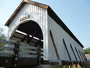 Wimer Bridge over Evans Creek | |
 Wimer  Wimer | |
| Coordinates: 42°32′19″N 123°08′56″W | |
| Country | United States |
| State | Oregon |
| County | Jackson |
| Area | |
| • Total | 4.96 sq mi (12.84 km2) |
| • Land | 4.96 sq mi (12.84 km2) |
| • Water | 0.00 sq mi (0.00 km2) |
| Elevation | 1,125 ft (343 m) |
| Population | |
| • Total | 690 |
| • Density | 139.20/sq mi (53.74/km2) |
| Time zone | UTC-8 (Pacific (PST)) |
| • Summer (DST) | UTC-7 (PDT) |
| FIPS code | 41-82850 |
| GNIS feature ID | 1129208 |
| Coordinates and elevation from Geographic Names Information System[3] | |
The community was named for a relative of William Wimer, who edited a newspaper in Grants Pass in 1886–87. Grants Pass is about 17 miles (27 km) southwest of Wimer. William Wimer was also said to have helped establish a post office in Wimer, which remained open until 1909. Simon E. Simpkins was the first postmaster.[6]
Wimer Bridge is a covered bridge that crosses Evans Creek in Wimer. It replaced a 1927 version of the bridge that collapsed into the creek in 2003. In 2008, with the help of federal funds and local labor, the bridge was replaced with a look-alike using stronger materials. The one-way bridge, still 17 feet (5.2 m) wide, as was the original, has a load limit of 10 tons.[7] This version of the bridge opened to traffic in February 2008.[8]
References
- "ArcGIS REST Services Directory". United States Census Bureau. Retrieved October 12, 2022.
- "Census Population API". United States Census Bureau. Retrieved October 12, 2022.
- "Wimer". Geographic Names Information System. United States Geological Survey, United States Department of the Interior. November 28, 1980. Retrieved February 18, 2016.
- "Geographic Identifiers: 2010 Census Summary File 1 (G001): Wimer CDP, Oregon". American Factfinder. U.S. Census Bureau. Archived from the original on February 13, 2020. Retrieved October 30, 2018.
- "United States Topographic Map". United States Geological Survey. Retrieved February 18, 2016 – via Acme Mapper.
- McArthur, Lewis A.; McArthur, Lewis L. (2003) [1928]. Oregon Geographic Names (7th ed.). Portland, Oregon: Oregon Historical Society Press. p. 1048. ISBN 978-0875952772.
- Mann, Damien (January 3, 2008). "Wimer Bridge Lives!". Medford Mail-Tribune. Local Media Group. Retrieved February 17, 2016.
- "International Database for Civil and Structural Engineering: Wimer Bridge". Structurae. Retrieved February 17, 2016.
- "Census of Population and Housing". Census.gov. Retrieved June 4, 2016.
Municipalities and communities of Jackson County, Oregon, United States | ||
|---|---|---|
| Cities |  Jackson County map | |
| CDPs | ||
| Other unincorporated communities | ||
| Ghost towns | ||