Wisit
Wisit (Thai: วิศิษฐ์) is a subdistrict (tambon) in Mueang Bueng Kan district, in Bueng Kan province, Isan (northeastern Thailand). As of 2022, it had a population of 10,278 people and has jurisdiction over thirteen villages.[1] It lies on Highway 212 and the Mekong River and borders with Laos, west of Bueng Kan subdistrict and east of Khai Si subdistrict.[2]
Wisit
วิศิษฐ์ | |
|---|---|
.jpg.webp) Wisit, Mueang Bueng Kan district, Bueng Kan 38000, Thailand | |
 Wisit | |
| Coordinates: 18.348°N 103.6308°E | |
| Country | Thailand |
| Province | Bueng Kan |
| District | Mueang Bueng Kan |
| Government | |
| • Type | Bueng Kan town municipality covers the subdistrict |
| Area | |
| • Total | 68.33 km2 (26.38 sq mi) |
| Population (2022)[1] | |
| • Total | 10,278 |
| • Density | 150/km2 (400/sq mi) |
| Time zone | UTC+7 (ICT) |
| Postal code | 38000 |
| Calling code | 042 |
| Geocode | 38011000 |
| Website | www |
History
On 25 March 2020, the Ministry of Interior announce to dissolve Wisit subdistrict municipality and Bueng Kan subdistrict administrative organization (SAO) and combine the two with Bueng Kan subdistrict municipality. Also upgrade the status of the latter to Bueng Kan town municipality. Published in Royal Gazette, volume 137, special section 179 Ngor, dated 5 August 2020 and effective on the same date.[3]
Geography
Generally, plains interspersed with undulating, uneven slopes.[4]
Administration
Central government
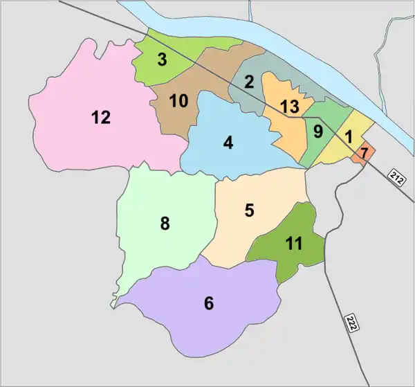
The administration of Wisit subdistrict (tambon) is responsible for an area that covers 42,708 rai ~ 68.33 square kilometres (26.38 sq mi) and consists of thirteen administrative villages (muban).[5]
As of 2022: 10,278 people.[1]

| Village | English | Thai | People |
|---|---|---|---|
| Moo1 | Ban Bueng Kan Nuea | บ้านบึงกาฬเหนือ | 1,070 |
| Moo2 | Ban Phan Lam | บ้านพันลำ | 460 |
| Moo3 | Ban Nong Waeng | บ้านหนองแวง | 753 |
| Moo4 | Ban Na Pan | บ้านนาป่าน | 968 |
| Moo5 | Ban Nong Na Saeng | บ้านหนองนาแชง | 546 |
| Moo6 | Ban Lao Thawon | บ้านเหล่าถาวร | 1,331 |
| Moo7 | Ban Wisit | บ้านวิศิษฐ์ | 1,972 |
| Moo8 | Ban Huai Dok Mai | บ้านห้วยดอกไม้ | 507 |
| Moo9 | Ban Na Nuea | บ้านนาหนือ | 811 |
| Moo10 | Ban Saen Charoen | บ้านแสนเจริญ | 397 |
| Moo11 | Ban Don Charoen | บ้านดอนเจริญ | 941 |
| Moo12 | Ban Na Suksan | บ้านนาสุขสันต์ | 179 |
| Moo13 | Ban Chak Thip Samakkhee | บ้านจักรทิพย้สามัคคี | 343 |
Temples
Wisit subdistrict is home to the following active temples, where Theravada Buddhism is practised by local residents:[6]
| Temple name | Thai | Location |
|---|---|---|
| Wat Buppharat Samoson | วัดบุพพราชสโมสร | Moo1 |
| Wat Charoen Tham | วัดเจริญธรรม | Moo2 |
| Wat Si Boon Rueang | วัดสรีบุญเรือง | Moo3 |
| Wat Chom Chaeng | วัดจอมแจ้ง | Moo4 |
| Wat Si Woramongkon | วัดสรีวรมงคล | Moo5 |
| Wat Tham Phra | วัดถ้ำพระ | Moo5 |
| Wat Si Boon Rueang Khanaram | วัดสรีบุญเรืองคณาราม | Moo6 |
| Wat Don Charoen | วัดดอนเจิญ | Moo11 |
| Wat Na Suksam | วัดนาสุขสันต์ | Moo12 |
References
- "Official statistics registration system". Department of Provincial Administration. Retrieved 11 August 2023, year 2022 >village level >ExcelFile >no.38011000 >Excel line 35267-35280
{{cite web}}: CS1 maint: postscript (link) - Maps (Map). Google Maps.
- "ประวัติ" [history] (in Thai). Retrieved 11 August 2023.
- "formerly Wisit Subdistrict Municipality". Retrieved 11 August 2023, 1.2 Topography
{{cite web}}: CS1 maint: postscript (link) - "formerly Wisit Subdistrict Municipality". Retrieved 11 August 2023, 1.1 Location of the village (area)
{{cite web}}: CS1 maint: postscript (link) - "list of temples". Retrieved 11 August 2023.