Woleu-Ntem Province
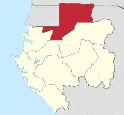
Woleu-Ntem is the northernmost of Gabon's nine provinces. It covers an area of 38,465 km2 and named after Woleu and Ntem rivers that cross it. The provincial capital is Oyem, which had a total of 60,685 inhabitants in 2013.
Woleu-Ntem | |
|---|---|
 Flag  Coat of arms | |
 Woleu-Ntem Province in Gabon | |
| Coordinates: 1°17′36″N 11°50′8″E | |
| Country | |
| Capital | Oyem |
| Area | |
| • Total | 38,465 km2 (14,851 sq mi) |
| Population (2013 census) | |
| • Total | 154,986 |
| • Density | 4.0/km2 (10/sq mi) |
| HDI (2017) | 0.641[1] medium |
As Woleu-Ntem is the most northerly province of Gabon, it is the only province that borders Cameroon, and the only one with multiple foreign borders (other two being the Republics of the Congo and of Equatorial Guinea). It borders the following areas of these countries:
- Sangha Department, Republic of the Congo – east
- South Province, Cameroon – north
- Kié-Ntem Province, Equatorial Guinea – northwest, north of Wele-Nzas
- Wele-Nzas Province, Equatorial Guinea – northwest, east of Centro Sur and south of Kié-Ntem
- Centro Sur Province, Equatorial Guinea – northwest, west of Wele-Nzas
Domestically, it borders the following provinces:
- Estuaire – southwest
- Moyen-Ogooué – south
- Ogooué-Ivindo – southeast
Departments

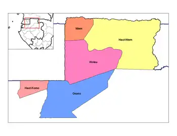
Departments of Woleu-Ntem
Woleu-Ntem is divided into 5 departments:
- Haut-Komo (department) (Médouneu)
- Haut-Ntem (department) (Minvoul)
- Ntem (department) (Bitam)
- Okano (department) (Mitzic)
- Woleu (department) (Oyem)
.jpg.webp)
Ntem river, Cameroon South Region (tropical forest)
References
- "Sub-national HDI - Area Database - Global Data Lab". hdi.globaldatalab.org. Retrieved 2018-09-13.
Sources
- The World Factbook
- https://www.amazinggabon.com/en/woleu-ntem-province/
- https://www.citypopulation.de/php/gabon-admin.php?adm1id=9
- https://www.fotw.info/flags/ga-wn.html
This article is issued from Wikipedia. The text is licensed under Creative Commons - Attribution - Sharealike. Additional terms may apply for the media files.