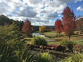
Wungong Regional Park
Wungong Regional Park is a conservation park near Bedfordale in the Perth Hills, 20 kilometres south-east of Perth, Western Australia, located within the City of Armadale.
| Wungong Regional Park | |
|---|---|
 Wungong Regional Park | |
| Type | Regional park |
| Location | City of Armadale |
| Coordinates | 32°11′15″S 116°03′12″E |
| Established | 2008 |
| Administered by | Department of Biodiversity, Conservation and Attractions |
| Website | Official website |
Overview
Wungong Regional Park was named after the Wungong townsite, established in 1909 which, in turn, had been named after the Wungong Brook, which was first traced by European explorers in 1835. The regional park's was name was confirmed in 2008, alongside three other regional parks and three national parks in the area, which were renamed to reflect the Aboriginal heritage of the area.[1]
Wungong is one of eleven regional parks in the Perth region of Western Australia. The purpose of these regional parks is to serve as urban havens to preserve and restore cultural heritage and valuable ecosystems as well as to encourage sustainable nature-based recreation activities.[2]
Area
Wungong Regional Park consists of the following reserves:[1]
| Image | Name | Location | Description | Co-ordinates |
|---|---|---|---|---|
| Armadale Settlers Common | Bedfordale | 32.152272°S 116.052205°E | ||
| Bungendore Park | Bedfordale | 32.182576°S 116.039079°E | ||
| Churchman’s Bushland | Roleystone | 32.145626°S 116.065534°E | ||
| Jarrahdale State Forest | Only parts of the Jarrahdale State Forest belong to the Wungong Regional Park | |||
| Wungong Valley | Bedfordale | 32.195889°S 116.059386°E |
References
- "New names for hills parks reflect Aboriginal heritage". Government of Western Australia. 7 August 2008. Archived from the original on 31 January 2019. Retrieved 10 June 2021.
- "National, marine and regional parks in Western Australia" (PDF). Department of Parks and Wildlife. June 2017. Retrieved 10 June 2021.
External links
- Parks and Wildlife Service: Wungong Regional Park
- Urban Bushland Council WA Inc.: Bungendore Park
- City of Armadale Bungendore Park Strategic Directions (2009)