Yüksekova District
Yüksekova District is a district in the Hakkâri Province of Turkey. Its seat is the city Yüksekova.[2] Its area is 2,547 km2 and had a population of 119,194 people in 2021.[3][1] It borders Iran to the east,[4] and Kurdistan Region of Iraq to the south.
Yüksekova District | |
|---|---|
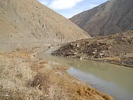 Typical landscape in Yüksekova District | |
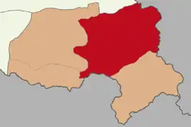 Map showing Yüksekova District in Hakkâri Province | |
| Country | Turkey |
| Province | Hakkâri |
| Seat | Yüksekova |
| Government | |
| • Kaymakam | Ömer Çimşit |
| Area | 2,547 km2 (983 sq mi) |
| Population (2021)[1] | 119,194 |
| • Density | 47/km2 (120/sq mi) |
| Time zone | TRT (UTC+3) |
| Website | www |
History
The district was historically an important trade route location due to its proximity to Iran.[4]
From the 1810s to Sayfo in 1915, the entire population of around the Great Zab was East Syriac Assyrian whose main occupation was agriculture that consisted of wheat, barley, cotton and tea.[4] The local Assyrian population were descendants of people who found refuge among Kurds from the Golden Horde in the early fifteenth century.[6][7]
Traveller Soane visisted the district in 1910, describing the area as 'one of the most inaccessible of the many sealed corners of this mountain country'.[6] After the genocide, Assyrian villages were subsequently populated by Kurds.[4]
In 1936, the name of the district was Turkified to Yüksekova, 'plateau'.[4]
Settlements
Beldes
The district encompasses three municipalities:[2]
- Yüksekova (Gever)
- Büyükçiftlik (Xirvata)
- Esendere (Bajêrgan)
Villages
The district has sixty-two villages of which three are unpopulated:[2][8]
- Adaklı (Alakan)
- Akalın (Bajêrge)
- Akçalı (Kertinis)
- Akocak (Heleyîs)
- Akpınar (Soryan)
- Aksu (Gagewran)
- Altınoluk (Elver)
- Armutdüzü (Metolanis)
- Aşağıuluyol (Tiloran)
- Bağdaş (Peranîs)
- Bataklık (Silîwana)
- Beşatlı (Xilxês)
- Beşbulak (Dara)
- Bostancık (Gulord)
- Bölük (Bolûk)
- Bulaklı (Memkan)
- Çatma (Sûsyan)
- Çukurca (Pagê)
- Dağlıca (Oremar)
- Dedeler (Zîzan)
- Değerli (Memkava)
- Demirkonak (Kaport)
- Dibekli (Awerd)
- Dilekli (Şuke)
- Dilektaşı (Manîs)
- Doğanlı (Ertuş)
- Gökyurt (Tekurawa)
- Güçlü (Peylan)
- Güldalı (Bilinbasan)
- Güllüce (Sekran)
- Gürdere (Ciwyan)
- Gürkavak (Şaglord)
- Ikiyaka (Sat)
- İnanlı (Xalanê)
- Kadıköy (Qadyan)
- Kamışlı (Sînava)
- Karabey (Serdeşt)
- Karlı (Befircan)
- Kazan (Tawani)
- Keçili (Sorê)
- Kısıklı (Dêlezî)
- Kolbaşı (Şavite)
- Köprücük (Kerpêl)
- Köşkönü (Piştqesir)
- Onbaşılar (Hirmîn)
- Ortaç (Bawenîs)
- Örnekköy (Miçîç)
- Pınargözü (Xelkan)
- Pirinçeken (Kinyaniş)
- Salkımlı (Niziran)
- Sarıtaş (Dirbêsan)
- Serindere (Şîşemzîn)
- Suüstü (Şakitan)
- Sürekli (Bêsitkê)
- Tatlı (Bîyan)
- Tuğlu (Haciyan)
- Vezirli (Vezîrawa)
- Yazılı (Talane)
- Yeniışık (Kineriwî)
- Yeşiltaş (Şitazin)
- Yoncalık (Pîrzalan)
- Yürekli (Herînk)
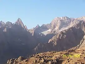
Climate
Yüksekova has a continental mediterranean climate (Köppen: Dsb). The winter months are cold and snowy, springs are cool and wet, autumns are mild and crisp, while the summer months are pleasantly warm and dry with cool nights. The average annual temperature is 6.9 °C and precipitation here averages 670 mm.[9]
| Climate data for Yüksekova | |||||||||||||
|---|---|---|---|---|---|---|---|---|---|---|---|---|---|
| Month | Jan | Feb | Mar | Apr | May | Jun | Jul | Aug | Sep | Oct | Nov | Dec | Year |
| Average high °C (°F) | −6.4 (20.5) |
−4.0 (24.8) |
2.7 (36.9) |
10.3 (50.5) |
17.6 (63.7) |
22.8 (73.0) |
26.7 (80.1) |
26.8 (80.2) |
23.2 (73.8) |
16.3 (61.3) |
7.7 (45.9) |
−3.3 (26.1) |
11.7 (53.1) |
| Daily mean °C (°F) | −9.0 (15.8) |
−7.3 (18.9) |
−0.7 (30.7) |
6.0 (42.8) |
12.1 (53.8) |
16.5 (61.7) |
20.3 (68.5) |
20.2 (68.4) |
16.4 (61.5) |
10.5 (50.9) |
3.3 (37.9) |
−5.5 (22.1) |
6.9 (44.4) |
| Average low °C (°F) | −11.5 (11.3) |
−10.6 (12.9) |
−4.0 (24.8) |
1.8 (35.2) |
6.6 (43.9) |
10.3 (50.5) |
13.6 (56.5) |
13.9 (57.0) |
9.6 (49.3) |
4.7 (40.5) |
−1.0 (30.2) |
−7.7 (18.1) |
2.1 (35.9) |
| Average precipitation mm (inches) | 71 (2.8) |
90 (3.5) |
104 (4.1) |
106 (4.2) |
58 (2.3) |
18 (0.7) |
6 (0.2) |
5 (0.2) |
6 (0.2) |
50 (2.0) |
76 (3.0) |
80 (3.1) |
670 (26.3) |
| Source: Climate-Data.org[10] | |||||||||||||
Gallery
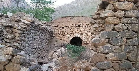 The ruins of the ancient Assyrian church of St. Mārī in the village of İkiyaka
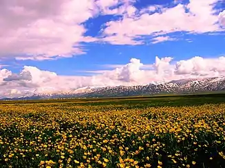 In spring
Notable people
- Hacı Karay (1950–1994)
- Savaş Buldan (1961–1994)
- Abdullah Zeydan (1972–)
References
- "31 ARALIK 2021 TARİHLİ ADRESE DAYALI NÜFUS KAYIT SİSTEMİ (ADNKS) SONUÇLARI" (XLS). TÜİK (in Turkish). Retrieved 16 December 2022.
- "Türkiye Mülki İdare Bölümleri Envanteri". T.C. İçişleri Bakanlığı (in Turkish). Retrieved 19 December 2022.
- "İl ve İlçe Yüz ölçümleri". General Directorate of Mapping. Retrieved 23 December 2022.
- "Kaza Gavar / Gever / Tergavar / Mergavar / Dize". Virtual Genocide Memorial. Retrieved 23 December 2022.
- Sinclair, T. A. (1987). Eastern Turkey: An Architectural and Archaeological Survey, Volume I. London: The Pindar Press. p. 255. ISBN 0-907132-52-9.
- Soane, E. B. (1910). To Mesopotamia and Kurdistan in disguise : with historical notices of the Kurdish tribes and Chaldeans of Kurdistan. Maynard and Company. p. 51.
- Sinclair, T. A. (1987). Eastern Turkey: An Architectural and Archaeological Survey, Volume I. London: The Pindar Press. p. 251. ISBN 0-907132-52-9.
- "Yüksekova köylerinin Kürtçe, Türkçe ve Eski isimleri". Yüksekova Haber (in Turkish). 27 January 2021. Retrieved 16 December 2022.
- "Climate Yüksekova: Temperature, Climograph, Climate table for Yüksekova - Climate-Data.org". en.climate-data.org. Retrieved 2018-01-16.
- "Climate:Yüksekova". Climate-Data.org. Retrieved 11 April 2014.
Yüksekova District in Hakkâri Province of Turkey | |||||||||||||||||||||||||||
|---|---|---|---|---|---|---|---|---|---|---|---|---|---|---|---|---|---|---|---|---|---|---|---|---|---|---|---|
| Districts |  Districts of Hakkâri | ||||||||||||||||||||||||||
| |||||||||||||||||||||||||||
Metropolitan municipalities are bolded. | |||||||||||||||||||||||||||