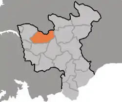
Yontan County
Yŏnt‘an County is a county in North Hwanghae province, North Korea.
Yŏnt‘an County
연탄군 | |
|---|---|
| Korean transcription(s) | |
| • Hanja | 燕灘郡 |
| • McCune-Reischauer | Yŏnt‘an-gun |
| • Revised Romanization | Yeontan-gun |
 Map of North Hwanghae showing the location of Yontan | |
| Country | North Korea |
| Province | North Hwanghae Province |
| Area | |
| • Total | 548.4 km2 (211.7 sq mi) |
| Population (2008[1]) | |
| • Total | 73,032 |
| • Density | 130/km2 (340/sq mi) |
Name
The name Yontan means "a fast stream like a swallow", which refers to the river that is fast that exists in the region.[2]
History
The county was newly created in 1952 from Myons from Hwangju County, Suan County and Sŏhŭng County.After Hwanghae Province was divided into North and south in 1954, the region became a county of North Hwanghae Province.[3]
Administrative divisions
Yŏnt‘an county is divided into 1 ŭp (town) and 16 ri (villages):
|
|
Industry
The county currently cultivates Choke berries(called Tannamu(단나무)) since 1985(at the period of the 40th anniversary of the founding of the WPK).[4]The region also artificially incubates eggs of Common pheasants, since the hunting of the birds were popular in the region.[5]
Notable places
References
- North Korea: Administrative Division
- "황해북도연탄군". cybernk.
- "연탄군". Encyclopedia of Korean Culture.
- "황해북도 연탄군, 10여년 전부터 단나무 재배". spn.
- "꿩 방사로 '까투리타령' 사라진 北연탄군". dailynk.
- "북, 고구려시대 추정 벽화고분 발굴". jeju news.
This article is issued from Wikipedia. The text is licensed under Creative Commons - Attribution - Sharealike. Additional terms may apply for the media files.
