Yugavia Flight S-519
Yugavia Flight S-519 was a Russian domestic flight from Elista to Makhachkala. On the afternoon of November 7, 1991, the plane crashed into the side of Mt. Kukurtbash, 23 km (14 miles) from the Makhachkala Airport, killing all 51 people on board.[2] This flight was the deadliest accident involving a Yakovlev Yak-40 at the time, and remains the second-deadliest accident to this day.[1]
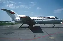
 An Aeroflot Yakovlev Yak-40, similar to the accident aircraft | |
| Accident | |
|---|---|
| Date | November 7, 1991 |
| Summary | Controlled flight into terrain due to ATC and pilot error[1] |
| Site | Mt. Kukurtbash, Makhachkala, Dagestan, Russia 42°58′N 47°29′E |
| Aircraft | |
| Aircraft type | Yakovlev Yak-40 |
| Operator | Aeroflot-Yugavia |
| Registration | CCCP-87526 |
| Flight origin | Elista International Airport, Elista, Kalmykia, Russia |
| Destination | Makhachkala International Airport "Uytash", Makhachkala, Dagestan, Russia |
| Occupants | 51 |
| Passengers | 47 |
| Crew | 4 |
| Fatalities | 51 |
| Survivors | 0 |
Background
Aircraft
The aircraft involved in the accident was a Yakovlev Yak-40, registered as CCCP-87526. It was manufactured in 1975, making it about 16 years old at the time of the crash. The plane was configured to seat 32 passengers, but 47 were crammed on board. 34 were listed as being on board and 13 boarded illegally. The plane was 260 kg (573 pounds) above its maximum takeoff weight (MTOW).[2]
Flight crew
- Captain: A. Milshin
- First officer: A. Shulepov
- Mechanic: M. Ochirov
- Flight attendant: B. Tsedenova
Accident
A total of four crew and 47 passengers boarded the plane in Elista, although only 34 passengers were listed on the flight manifest. There were 39 adults and 8 children on board. The plane took off from Elista at 12:43 p.m.[3]
The plane was supposed to follow the Aktur-Almar-Ronka-Kizlyar path and go through Flight Corridor 3 to descend for landing. After takeoff, the plane first leveled off at 5100 meters (16,732 ft). After passing Aktur at 12:58 p.m., and getting in contact with an ATC controller in sector B1, the plane climbed to 5700 meters (18,700 ft) and leveled off at 1:01 p.m. The crew then requested to fly off-route and head straight to Kizlyar, bypassing Ronka. Straightening of the route would have required extra coordination between the ATC dispatchers, so the controller in contact with authorized a route over Grozny towards Kizlyar.[3]
At 1:23 p.m. the plane entered sector M1 airspace and contacted an ATC controller at the Astrakhan center. The crew reported an altitude of 5700 meters (18,700 ft). Violating the correct approach path and flight operation instructions, the controller authorized a route directly to Makhachkala radio beacon. The crew knew this would take them over the mountains near Makhachkala, but carried out the command nonetheless.[3]
At 1:34 p.m., the aircraft descended to an altitude of 5100 meters (16,732 ft) and was 100 km (62 miles) from the Makhachkala Airport, as well as 35 km (22 miles) to the right of the approach air corridor number three. The crew was in contact with the approach controller. The ATC controller did not inform the crew that they were not following the established approach path. The controller, also violating protocol, gave the command for the plane to descend to 1800 meters (5905 ft) along an unspecified descent trajectory. Once the plane reached this altitude at 1:39 p.m., it was handed to the landing controller. At this time, the plane was 45 km (28 miles) from the Makhachkala Airport and 23 km (14 miles) to the right of the approach corridor. The crew followed the approach controller's instructions without clarifying their location or turning towards air corridor number three.[3]
Once getting in contact with the landing controller, the crew were given an incorrect bearing of 122º and a distance of 36 km (22 miles) from the airport, when in fact the plane was at 118º and 41 km (25 miles). The controller authorized a descent to 1050 meters (3444 ft) although the minimum descent altitude of the area was 1800 meters (5905 ft).[3]
The plane reached 1050 meters (3444 ft) at 1:41 p.m. At 1:42 p.m., the controller authorized a descent to 400 meters (1312 ft) and approach bearing of 143º. The sky at the time was covered with a thick layer of clouds, and the crew believed the cloud layer was at 980 meters (3215 ft) and intended to break through the layer and land under visual flight rules (VFR). The plane was not equipped with a ground proximity warning system (GPWS).[3]
The plane began their final turn before landing at 1:42:51 p.m., and five seconds later at 1:42:56 p.m. crashed until the slope of Mt. Kukurtbash at an altitude of 894 meters (2933 ft), 23 km (14 miles) west of the Makhachkala Airport.[3]
Probable cause
The cause of the crash was listed as "the result of gross violations by ATC personnel and the crew of flight rules and ATC in mountainous areas, which led to the aircraft descending below a safe altitude outside the established pattern, colliding with a mountain and completely destroying the aircraft."[3]
See also
References
- "ASN Aircraft accident Yakovlev Yak-40 CCCP-87526 Makhachkala, Russia". Retrieved 29 September 2023.
- "Crash of a Yakovlev Yak-40 in Makhachkala: 51 killed". Retrieved 29 September 2023.
- "Yak-40 crash of the Elistinsky JSC Yugavia aircraft concern near Makhachkala". Retrieved 29 September 2023.