Záhorovice
Záhorovice (German: Zahorowitz) is a municipality and village in Uherské Hradiště District in the Zlín Region of the Czech Republic. It has about 1,000 inhabitants.
Záhorovice | |
|---|---|
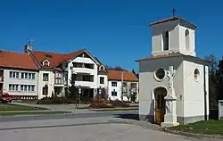 Chapel and municipal office | |
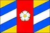 Flag 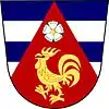 Coat of arms | |
 Záhorovice Location in the Czech Republic | |
| Coordinates: 49°1′22″N 17°46′45″E | |
| Country | |
| Region | Zlín |
| District | Uherské Hradiště |
| First mentioned | 1373 |
| Area | |
| • Total | 14.92 km2 (5.76 sq mi) |
| Elevation | 248 m (814 ft) |
| Population (2023-01-01)[1] | |
| • Total | 1,021 |
| • Density | 68/km2 (180/sq mi) |
| Time zone | UTC+1 (CET) |
| • Summer (DST) | UTC+2 (CEST) |
| Postal code | 687 71 |
| Website | www |
Geography
Záhorovice is located about 23 kilometres (14 mi) east of Uherské Hradiště and 24 km (15 mi) south of Zlín. It lies on the border between the Vizovice Highlands and White Carpathians. The highest point is Valy with an elevation of 470 metres (1,540 ft). The Olšava river flows through the municipality.
This article is issued from Wikipedia. The text is licensed under Creative Commons - Attribution - Sharealike. Additional terms may apply for the media files.