Zhob District
Zhob District (Pashto: ږوب ولسوالۍ, Urdu: ضلع ژوب) is a district in the north west of Balochistan province of Pakistan. The population of Zhob District is estimated to 310,544 in 2017.[2] Zhob River is used for irrigation in the Zhob District.
Zhob District
ږوب ولسوالۍ | |
|---|---|
  Top: Zhob Bazaar Bottom: Mountains near Zhob | |
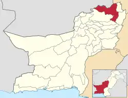 Map of Balochistan with Zhob District highlighted | |
| Country | |
| Province | |
| Division | Zhob |
| Established | 1890 |
| Founded by | British government |
| Headquarters | Zhob(Formally Fort Sandeman) |
| Government | |
| • Type | District Administration |
| • Deputy Commissioner | N/A |
| • District Police Officer | N/A |
| • District Health Officer | N/A |
| Area | |
| • Total | 15,987 km2 (6,173 sq mi) |
| Population (2017)[1] | |
| • Total | 310,354 |
| • Density | 19/km2 (50/sq mi) |
| Time zone | PKT |
| Number of Tehsils | 5 |
| Main Language(s) | Pashto |
Administration
The 1998 census report lists two sub-divisions: Lower Zhob (comprising Zhob tehsil and Sambaza sub-tehsil) and Kakar Khurasan (encompassing the tehsil of Qamar Din Karez and the subtehsil of Ashewat).[3] A government webpage lists these as Ashwat, Qamar Din Karez, Sambaza and Zhob, without indicating if any of them are sub-tehsils.[4]
Demography
At the time of the 2017 census the district had 44,839 households and a population of 310,354. Zhob had a sex ratio of 845 females per 1000 males and a literacy rate of 33.44%: 43.12% for males and 22.01% for females. 46,164 (14.87%) lived in urban areas. 118,986 (38.34%) were under 10 years of age. 1,107 (0.36%) people in the district were from religious minorities.[1]
At the time of the 2017 census, 96.03% of the population spoke Pashto and 1.71% Saraiki as their first language.[1]
The majority of the population of Zhob district is Pashtun. The tribes of Zhob district include the Mandokhail, Khosti, Sherani, Kakar, Sulaimankhel, Harifal, Lawoon and Babar. Currently a large number of IDPs and have been settled within the confines of the District as part of the evacuation from Operation Zarb-e-Azb taking place to the north of Zhob.
References
- "District Census Tables: Zhob". www.pbscensus.gov.pk. Pakistan Bureau of Statistics.
- "DISTRICT WISE CENSUS RESULTS CENSUS 2017" (PDF). www.pbscensus.gov.pk.
- PCO 1998, p. 10.
- "List of Tehsils/Talukas with respect to their Districts" Federal Bureau of Statistics, Pakistan Archived 30 December 2010 at the Wayback Machine
Bibliography
- 1998 District Census report of Zhob. Census publication. Vol. 107. Islamabad: Population Census Organization, Statistics Division, Government of Pakistan. 2000.
External links
www.zamazhob.asia
Provincial capital: Quetta | ||
| Kalat |  | |
| Makran | ||
| Nasirabad | ||
| Quetta | ||
| Sibi | ||
| Zhob | ||
| Rakhshan | ||
| Loralai | ||
a - formerly part of Quetta Division; b - formerly part of Kalat Division; c - formerly part of Zhob Division | ||