Sakai
Sakai (堺市, Sakai-shi) is a city located in Osaka Prefecture, Japan. It has been one of the largest and most important seaports of Japan since the medieval era. Sakai is known for its keyhole-shaped burial mounds, or kofun, which date from the fifth century and include Daisen Kofun, the largest grave in the world by area. Once known for swords, Sakai is now famous for the quality of its cutlery. As of 1 January 2022, the city had an estimated population of 819,965,[2] making it the fourteenth most populous city in Japan (excluding Tokyo).
Sakai
堺市 | |
|---|---|
Designated city | |
| Sakai City[1] | |
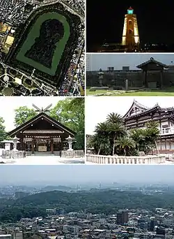 From top left: Daisen Kofun, Old Sakai Lighthouse, Ruins of Rikyu's house, Ōtori taisha, Myōkoku-ji, Skyline with Daisen kofun in the center | |
 Flag  Seal | |
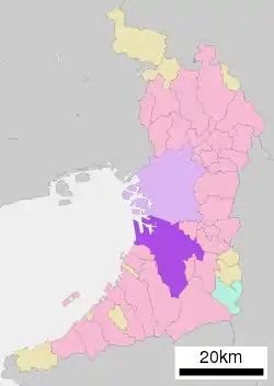
 Location of Sakai in Osaka Prefecture | |
 | |
 Sakai Location in Japan | |
| Coordinates: 34°34′24″N 135°28′59″E | |
| Country | Japan |
| Region | Kansai |
| Prefecture | Osaka |
| Government | |
| • Mayor | Hideki Nagafuji (from June 2018) |
| Area | |
| • Total | 149.82 km2 (57.85 sq mi) |
| Population (January 1, 2022) | |
| • Total | 819,965 |
| • Density | 5,500/km2 (14,000/sq mi) |
| Time zone | UTC+09:00 (JST) |
| City hall address | 3-1 Minami-Kawaramachi, Sakai-ku, Sakai-shi, Osaka-fu 590-0078 |
| Climate | Cfa |
| Website | Official website |
| Symbols | |
| Bird | Shrike |
| Flower | Iris |
| Tree | Willow |
Geography
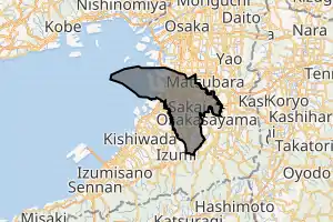
Sakai is located in southern Osaka Prefecture, on the edge of Osaka Bay and directly south of the city of Osaka.
Neighboring municipalities
Osaka Prefecture
- Osaka
- Matsubara
- Habikino
- Ōsakasayama
- Kawachinagano
- Izumi
- Takaishi
Climate
Sakai has a Humid subtropical climate (Köppen Cfa) characterized by warm summers and cool winters with light to no snowfall. The average annual temperature in Sakai is 16.5 °C (61.7 °F). The average annual rainfall is 1,232.9 mm (48.54 in) with June as the wettest month. The temperatures are highest on average in August, at around 28.6 °C (83.5 °F), and lowest in January, at around 5.6 °C (42.1 °F).[3]
| Climate data for Sakai (1991−2020 normals, extremes 1977−present) | |||||||||||||
|---|---|---|---|---|---|---|---|---|---|---|---|---|---|
| Month | Jan | Feb | Mar | Apr | May | Jun | Jul | Aug | Sep | Oct | Nov | Dec | Year |
| Record high °C (°F) | 19.1 (66.4) |
23.9 (75.0) |
25.6 (78.1) |
30.2 (86.4) |
33.0 (91.4) |
36.3 (97.3) |
37.9 (100.2) |
39.7 (103.5) |
36.8 (98.2) |
32.7 (90.9) |
27.5 (81.5) |
25.5 (77.9) |
39.7 (103.5) |
| Average high °C (°F) | 9.6 (49.3) |
10.5 (50.9) |
14.3 (57.7) |
20.0 (68.0) |
24.9 (76.8) |
28.1 (82.6) |
32.0 (89.6) |
33.9 (93.0) |
29.6 (85.3) |
23.6 (74.5) |
17.8 (64.0) |
12.3 (54.1) |
21.4 (70.5) |
| Daily mean °C (°F) | 5.6 (42.1) |
6.0 (42.8) |
9.3 (48.7) |
14.6 (58.3) |
19.4 (66.9) |
23.1 (73.6) |
27.2 (81.0) |
28.6 (83.5) |
24.6 (76.3) |
18.6 (65.5) |
12.9 (55.2) |
7.9 (46.2) |
16.5 (61.7) |
| Average low °C (°F) | 1.6 (34.9) |
1.7 (35.1) |
4.5 (40.1) |
9.3 (48.7) |
14.4 (57.9) |
19.1 (66.4) |
23.4 (74.1) |
24.5 (76.1) |
20.6 (69.1) |
14.3 (57.7) |
8.4 (47.1) |
3.9 (39.0) |
12.1 (53.8) |
| Record low °C (°F) | −5.0 (23.0) |
−5.3 (22.5) |
−3.3 (26.1) |
−1.1 (30.0) |
4.1 (39.4) |
9.1 (48.4) |
15.5 (59.9) |
16.6 (61.9) |
9.7 (49.5) |
2.7 (36.9) |
−0.9 (30.4) |
−3.4 (25.9) |
−5.3 (22.5) |
| Average precipitation mm (inches) | 48.3 (1.90) |
57.8 (2.28) |
97.8 (3.85) |
92.2 (3.63) |
126.7 (4.99) |
164.1 (6.46) |
154.2 (6.07) |
87.3 (3.44) |
139.0 (5.47) |
139.3 (5.48) |
74.6 (2.94) |
51.9 (2.04) |
1,232.9 (48.54) |
| Average precipitation days (≥ 1.0mm) | 6.4 | 6.9 | 9.5 | 9.3 | 9.6 | 11.8 | 10.3 | 6.6 | 10.0 | 8.9 | 6.8 | 6.6 | 102.6 |
| Mean monthly sunshine hours | 138.3 | 138.7 | 173.5 | 194.6 | 206.9 | 160.6 | 190.6 | 228.6 | 160.4 | 163.0 | 147.5 | 138.7 | 2,041.4 |
| Source: Japan Meteorological Agency[3][4] | |||||||||||||
Demographics
According to Japanese census data,[5] the population of Sakai increased rapidly in the 1960s and 1970s, and has been relatively stable since.
| Year | Pop. | ±% |
|---|---|---|
| 1960 | 383,559 | — |
| 1970 | 616,558 | +60.7% |
| 1980 | 839,421 | +36.1% |
| 1990 | 844,899 | +0.7% |
| 2000 | 829,636 | −1.8% |
| 2010 | 842,132 | +1.5% |
| 2020 | 826,161 | −1.9% |
History
Origins
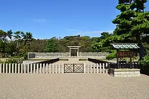
The area that would later become known as Sakai has been inhabited since approximately 8,000 BC.[6] Sakai is known for its keyhole-shaped burial mounds, or kofun, which date from the 5th century. The largest of these, Daisen Kofun, is believed to be the grave of the Emperor Nintoku and is the largest grave in the world by area. During the Kofun period between 300 and 500 AD, the Mozu Tumulus Cluster was built from over one hundred burial mounds.[6] The name "Sakai" appears in Fujiwara Sadoyori's poetry by 1045.[7] Most of the current city is located within ancient Izumi Province; however, the wards of Mihara, Higashi and a portion of Kita are located within ancient Kawachi Province.
Tradition holds that 10,000 homes burned to the ground in 1399.[7]
 Daisen Kofun
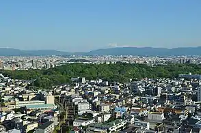 Mozu Tombs
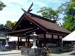 Ōtori taisha
01.jpg.webp) Yamato Takeru
Yamato Takeru
Middle Ages
Medieval Sakai was an autonomous city run by merchant oligarchs. During the Muromachi and Sengoku periods from about 1450 to 1600, Sakai developed into one of richest cities in Japan as a port for foreign trade. It was a leading producer of textiles and ironwork.[8] In those days, it was said that the richest cities were Umi no Sakai, Riku no Imai (tr. "along the sea, Sakai; inlands, Imai"; the latter is now a part of Kashihara, Nara). The famous Zen Buddhist priest Ikkyū chose to live in Sakai because of its free atmosphere. The first reliable account of the city is dated to the 1480s and contains publicly issued legal notices, which suggests that the city had a governing council at that point. By the 1530s, the population was around 40,000 residents, almost all of which earned a living through commercial enterprises and some of whom were the wealthiest people in Japan. At this time, Sakai was administered by an oligarchy of powerful merchants. The government had ten divisions machi that were subordinate to the representative council of wealthy townsmen known as the egoshu.[8][9]
Sen no Rikyū, known as the greatest master of the tea ceremony, was originally a merchant of Sakai. Because of the close relationship between the tea ceremony and Zen Buddhism and because of the prosperity of its citizens, Sakai was one of the main centers of the tea ceremony in Japan.
In the Sengoku period, Christian missionaries, including Francis Xavier in 1550, visited Sakai and documented its prosperity. Gaspar Vilela described the town as the safest place in the area when he visited in 1561.[10] He also mentioned that the city was "governed by consuls like Venice in Italy".[8][11]
After the coming of Europeans, Sakai became a manufacturing base of matchlock firearms and a daimyō, Oda Nobunaga, was one of their important customers. During his ambitious attempt to unify Japan, Nobunaga attempted to take the autonomy privilege from Sakai. Sakai's citizens denied his order and pitched a desperate battle against his army. Most citizens fled and Sakai was burned and seized by Nobunaga.
After the assassination of Nobunaga in 1582, Toyotomi Hideyoshi, seized power and abolished the autonomous system of Sakai, forcing many merchants to move to his stronghold in Osaka.[12]
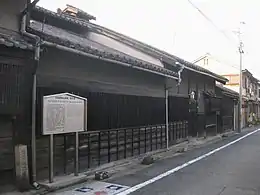 Old house of gunsmiths in Sakai
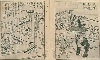 Gunsmith storefront in Sakai, Osaka
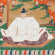
In 1615, Sakai was razed to the ground in the SummerCampaign of the Siege of Osaka between the Toyotomi clan and Tokugawa Ieyasu.[7]
Sakai was restored as an important trade center during the Edo period but was involved only in inland trade due to the sakoku policy of the Tokugawa shogunate, which isolated Japan from the outside world. It was also known for its sake brewing and its cutlery industries. After the isolation policy was abandoned during the Bakumatsu period, Sakai was the location of the Sakai Incident, involving a clash between French sailors and Japanese gendarmes resulting in multiple casualties. When the Western powers demanded the opening of Osaka a port for foreign trade, both Sakai and Hyōgo were named as candidates; however, Sakai's proximity and ease of access to Kyoto and the presence of many imperial tombs led to the selection of Hyōgo.
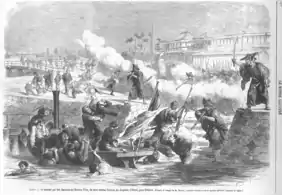 Sakai incident(1868)
Modern Sakai
Following the Meiji restoration, Sakai was transformed into an industrial center as part of the Hanshin Industrial Region, with industries centering on textiles and brick making. From 1876 to 1881, Sakai was part of Nara Prefecture. The city of Sakai was proclaimed on April 1, 1889 with the creation the modern municipalities system. It was one of the first 31 cities to be created in Japan. The 1934 Muroto typhoon killed over 300 people in Sakai. Another major disaster was in 1945, when the city was heavily bombed on six occasions during World War II with over 1800 civilian deaths. Following the February 2005 annexation of the town of Mihara (from Minamikawachi District), Sakai became a designated city in April 2006[13] giving it a greater measure of self-determination in governmental affairs.
Government
Sakai has a mayor-council form of government with a directly elected mayor and a unicameral city council of 52 members. Sakai contributes eight members to the Osaka Prefectural Assembly. In terms of national politics, the city is divided between the Osaka 15th district, Osaka 16th district and Osaka 17th districts of the lower house of the Diet of Japan.
Local administration
Sakai has seven wards (ku):
| Wards of Sakai | |||||||
|---|---|---|---|---|---|---|---|
| Place Name | Map of Sakai | ||||||
| Rōmaji | Kanji | Population | Land area in km2 | Pop. density per km2 | |||
| 1 | Sakai-ku(administrative center) | 堺区 | 148,353 | 23.66 | 6,270 | 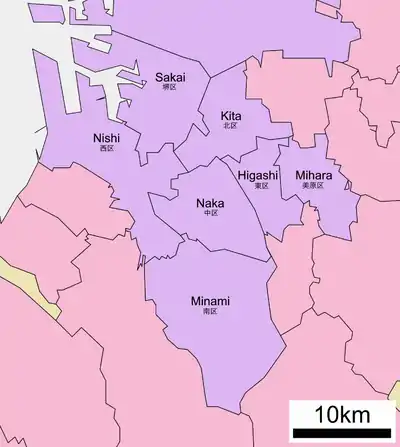 A map of Sakai's Wards | |
| 2 | Higashi-ku | 東区 | 84,708 | 10.49 | 8,075 | ||
| 3 | Kita-ku | 北区 | 159,084 | 15.60 | 10,198 | ||
| 4 | Naka-ku | 中区 | 120,216 | 17.88 | 6,723 | ||
| 5 | Nishi-ku | 西区 | 134,389 | 28.62 | 4,696 | ||
| 6 | Mihara-ku | 美原区 | 37,223 | 13.20 | 2,820 | ||
| 7 | Minami-ku | 南区 | 135,992 | 40.39 | 3,367 | ||
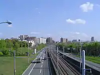
Cityscape
- Gallery
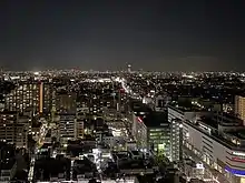 Sakai City Downtown(2020)
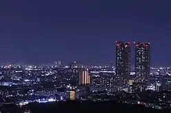 Sakai City Skyline(2020)
 Old Sakai Port(2020)
.jpg.webp) Daisen Park(2019)
Daisen Park(2019)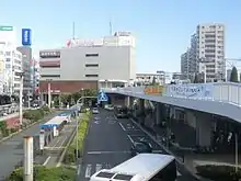 Sakaihigashi Station(2016)
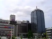 Sakai City Hall(2009)
Economy
Sakai was traditionally dependent on heavy industry and its port. However, after the period of high economic growth after War War II, along with the development and expansion of the Osaka metropolitan area, Sakai also has lso increased become a satellite city (commuter town) for Osaka metropolis, as represented by the development of Senboku New Town. Shimano, a major manufacturer of cycling and fishing products, is based in Sakai.
Kura Sushi, the conveyor belt sushi chain, has its headquarters in Sakai.[14]
Education

Universities
- Osaka Prefecture University
- Hagoromo International University
- Kansai University Sakai Campus
- Poole Gakuin University
- Taisei Gakuin University
- Tezukayama Gakuin University
- Osaka Butsuryo University
- Osaka Junior College of Social Health and Welfare
- Sakai Women's Junior College
Primary and secondary schools
Sakai has 98 public elementary schools and 43 public middle schools operated by the city government. The city also has one private elementary school, three private combined middle/high schools and one private combined elementary/middle/high school. The city has 23 public high schools operated by the Osaka Prefectural Board of Education, and four private high schools. The city operates two and the prefecture operates four special education schools for the disabled.
The city previously had a North Korean school, Sakai Korean Elementary School (堺朝鮮初級学校).[15]
Transportation
Airport
Sakai does not have an airport. The nearest major airport is Kansai International Airport.
Railways
![]() JR West – Hanwa Line
JR West – Hanwa Line
- Asaka - Sakaishi - Mikunigaoka - Mozu - Uenoshiba - Tsukuno - Ōtori
![]() Nankai Electric Railway -
Nankai Electric Railway - ![]() Nankai Main Line
Nankai Main Line
- Shichidō - Sakai - Minato - Ishizugawa - Suwanomori - Hamaderakōen
![]() Nankai Electric Railway -
Nankai Electric Railway - ![]() Kōya Line
Kōya Line
- Asakayama - Sakaihigashi - Mikunigaoka - Mozuhachiman - Nakamozu - Shirasagi] - Hatsushiba - Hagiharatenjin - Kitanoda
![]() Semboku Rapid Railway Co., Ltd. - Semboku Rapid Railway
Semboku Rapid Railway Co., Ltd. - Semboku Rapid Railway
- Nakamozu - Fukai - Izumigaoka - Toga-Mikita] - Kōmyōike
Subway
![]() Osaka Metro -
Osaka Metro - ![]() Midōsuji Line
Midōsuji Line
- Kitahanada - Shinkanaoka - Nakamozu
Tramway
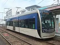
- Hankai Tramway
- Hankai Line:(Sumiyoshi)- Yamatogawa - Takasu-jinsha - Ayanocho - Shimmeicho - Myokokuji-mae - Hanataguchi - Oshoji - Shukuin - Terajicho - Goryomae - Higashi-Minato - Ishizu-Kita - Ishizu - Funao - Hamaderakōen
Bus
- Nankai Bus Company, Limited
- Nankai wing Bus kanaoka Company, Limited
- Kintetsu Bus
- Osaka City Bus
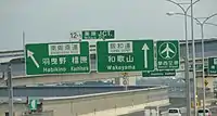
Expressways
.png.webp) Hanwa Expressway
Hanwa Expressway.png.webp) Sakai Senboku Road
Sakai Senboku Road.png.webp) Minami-Hanna Road
Minami-Hanna Road Hanshin Expressway
- 4 Bayshore Route
- 6 Yamatogawa Route
- 15 Sakai Route
Japan National Route
 National Route 26
 National Route 309
 National Route 310
International relations
Sister cities
 Berkeley, California, United States (1967)
 Lianyungang, Jiangsu, China (1983)
 Wellington, New Zealand (1994)
Friendship cities
 Tanegashima, Kagoshima, Japan (1986)
- Higashiyoshino, Nara, Japan (1986)
 Da Nang, Vietnam (2019)
Notable people from Sakai
- Sen no Rikyū, founder of Tea ceremony
- Kataoka Ainosuke VI, Kabuki actor, actor, television presenter and entertainer.
- Yuki Morisaki, chef and entertainer
- Reon Kadena, glamour model and actress
- Emperor Nintoku, the 16th Emperor of Japan
- Gyōki, Japanese Buddhist priest of the Nara period
- Ikkyū, Zen Buddhist monk and poet.
- Sen no Rikyū, Japanese tea master
- Tsuda Sōgyū, Japanese tea master
- Imai Sōkyū, Japanese tea master and merchant
- Ōuchi Yoshihiro, Muromachi period samurai clan head and military leader
- Kenzō Tange, Japanese award-winning architect
- Takeno Jōō
- Oreskaband, all-female ska band
- Nobuaki Kakuda, karateka and kickboxer
- Hiroki Suzuki, Japanese actor and singer
- Kentaro Kobuchi and Shunsuke Kuroda, the members of the music group Kobukuro
- Akiko Yosano, poet and novelist
- Ryumon Yasuda, painter and sculptor
- Hideo Nomo worked in Shin-nittetsu Sakai and played on its club team before he was scouted by the Kintetsu Buffaloes
- Yudetamago, manga artist duo (attended Hatsushiba High School in Higashi-ku)
- Akio Mori, a well known K-1 kickboxer known as Musashi (kickboxer)
- Akira Nagata, actor and singer/vocalist, member of J-pop group Run&Gun
- CIMA, Japanese professional wrestler
Local attractions
- Mozu Kofun Cluster
- Kurohimeyama Kofun
- Yotsu-ike Site
- Dotō
- Sakai City Museum
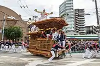
- Sakai Matsuri
- Tsukuno Danjiri Matsuri
See also
- Osaka Metropolis plan
References
- Sakai official English name Archived February 26, 2010, at the Wayback Machine
- "Sakai city official statistics" (in Japanese). Japan.
- "平年値(年・月ごとの値)". JMA. Retrieved May 19, 2021.
- "観測史上1~10位の値(年間を通じての値)". JMC. Retrieved August 10, 2012.
- Sakai population statistics
- "Welcome to Sakai!".
- "History".
- The Oxford Handbook of Cities in World History edited by Peter Clark https://books.google.com/books?id=z09oAgAAQBAJ&pg=PA331&lpg=PA331&dq=Gaspar+Vilela+sakai+consuls
- An Introduction to the History of Japan by Katsuro Hara https://books.google.com/books?id=k-lBAAAAIAAJ&pg=PA241&lpg=PA241&dq=sakai+japan+autonomous+merchant
- "Sakai: A keyhole to the history of Osaka". April 11, 2015.
- "Japan's oldest 'autonomous' city splits over Osaka Metropolis Plan – Xinhua | English.news.cn". news.xinhuanet.com. Archived from the original on September 24, 2013. Retrieved May 8, 2016.
- "Japan's oldest "autonomous" city splits over Osaka Metropolis Plan - Xinhua | English.news.cn". news.xinhuanet.com. Archived from the original on September 24, 2013.
- "Tokyo pollsters in the money", Yomiuri Shimbun, February 17, 2007. Accessed March 13, 2007.
- "Company". Kura Sushi. Retrieved June 11, 2022.
1-2-1 Fukasaka, Naka-ku, Sakai-shi, Osaka 599-8253, Japan
- Address in Japanese: "大阪府堺市中区深阪1-2-2" - "|script-title=ja:ウリハッキョ一覧 |publisher=Chongryon |date=November 6, 2005 |accessdate=October 15, 2015}}}} ([https://www.webcitation.org/6cHKwmz4m?url=http://web.archive.org/web/20051106010302/http://www.chongryon.com/j/cr/link3.html Archive).
External links
- Sakai City official website (in Japanese)
 Sakai travel guide from Wikivoyage
 Geographic data related to Sakai at OpenStreetMap
| |||||||||||||||||||||||||||||||||||||