Vatnajökull
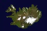
Vatnajökull (Icelandic pronunciation: [ˈvahtnaˌjœːkʏtl̥] (![]() listen), literally "Glacier of Lakes"; sometimes translated as Vatna Glacier in English) is the largest and most voluminous ice cap in Iceland, and the second largest in area in Europe after the Severny Island ice cap of Novaya Zemlya.[1] It is in the south-east of the island, covering approximately 8% of the country.[2]
listen), literally "Glacier of Lakes"; sometimes translated as Vatna Glacier in English) is the largest and most voluminous ice cap in Iceland, and the second largest in area in Europe after the Severny Island ice cap of Novaya Zemlya.[1] It is in the south-east of the island, covering approximately 8% of the country.[2]
| Vatnajökull | |
|---|---|
| Vatna Glacier | |
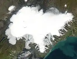 Vatnajökull, Iceland | |
| Type | Ice cap |
| Location | Iceland |
| Coordinates | 64°24′N 16°48′W |
| Area | 7,900 km2 (3,100 sq mi) |
| Thickness | 380 m (1,250 ft) average |
| Terminus | Outlet glaciers |
| Status | Retreating |
Size
With an area of 7,900 km2,[1] Vatnajökull is the second largest ice cap in Europe by volume (about 3,000 km3)[1] and area (after the still larger Severny Island ice cap of Novaya Zemlya, Russia, which is in the extreme northeast of Europe).[1] On 7 June 2008, it became a part of the Vatnajökull National Park.[3]
The average thickness of the ice is 380 m (1,250 ft),[1] with a maximum thickness of 950 m (3,120 ft).[4] Iceland's highest peak, Hvannadalshnúkur (2,109.6 m (6,921 ft)), as part of the Öræfajökull, is in the southern periphery of Vatnajökull, near Skaftafell.
Volcanoes
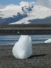
Under the ice cap, as under many of the glaciers of Iceland, there are several volcanoes.[2] Eruptions from these volcanoes have led to the development of large pockets of water beneath the ice, which may burst the weakened ice and cause a jökulhlaup (glacial lake outburst flood).[2] During the last ice age, numerous volcanic eruptions occurred under Vatnajökull, creating many subglacial eruptions.[5]
In more modern times, the volcanoes continue to erupt beneath the glaciers, resulting in many documented floods. One jökulhlaup in 1934 caused the release of 15 km3 (3.6 cu mi) of water over the course of several days.[5] The volcanic lake Grímsvötn was the source of a large jökulhlaup in 1996.[6] There was also a considerable but short-lived eruption of the volcano under these lakes at the beginning of November 2004.[7] On 21 May 2011 a volcanic eruption started in Grímsvötn in Vatnajökull National Park at around 7 p.m.[7] The plume reached up to 17 kilometres (11 mi).[7]
In culture
An Icelandic older name for Vatnajökull was Klofajökull [ˈkʰlɔːvaˌjœːkʏtl̥], which is known from eighteenth-century sources such as the writings of Eggert Ólafsson and Bjarni Pálsson.[8] In September 1950, a Douglas DC-4 operated by the private airline Loftleiðir crash-landed on the Vatnajökull glacier. The entire six-person crew survived. A rescue operation was launched after the crew managed to send a distress signal on the fourth day. The crew and the rescue team walked the 34 km to safety.[9]
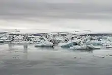
The glacier was used as the setting for the opening sequence (set in Siberia) of the 1985 James Bond film A View to a Kill, in which Bond (played for the last time by Roger Moore) eliminated a host of armed villains before escaping in a submarine to Alaska.[10] Several other films, including another in the Bond franchise, have been filmed on or using Jökulsárlón, the terminal lake of the Breiðamerkurjökull outlet from Vatnajökull.
In 2004, Vatnajökull was one of several Icelandic settings visited on the first leg of The Amazing Race 6.[11]
Westlife's official music video for their twenty-fifth single top 10 and #2 UK hit in 2009 "What About Now" is the last film of Vatnajökull Glacier before the subsequent volcanic eruption.[12]
In November 2011, the glacier was used as a shooting location for the second season of the HBO fantasy TV series Game of Thrones.[13]
Outlet glaciers
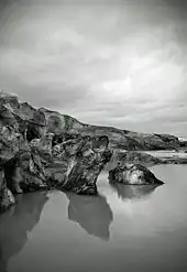
Vatnajökull has around 30 outlet glaciers flowing from the ice cap. The Icelandic term for glacier is "jökull", and so is the term for outlet glacier. Given below is a list of outlet glaciers flowing from Vatnajökull, sorted by the four administrative territories of Vatnajökull National Park.[14] This is not a complete list.
Southern territory
- Breiðamerkurjökull
- Brókarjökull [ˈprouːkarˌjœːkʏtl̥]
- Falljökull [ˈfatlˌjœːkʏtl̥]
- Fjallsjökull [ˈfjalsˌjœːkʏtl̥]
- Fláajökull [ˈflauːaˌjœːkʏtl̥]
- Heinabergsjökull [ˈheiːnaˌpɛrksˌjœːkʏtl̥, -ˌpɛr̥s-]
- Hoffellsjökull
- Hólárjökull [ˈhouːlˌaurˌjœːkʏtl̥]
- Hrútárjökull [ˈr̥uːtˌaurˌjœːkʏtl̥]
- Kvíárjökull [ˈkʰviːˌaurˌjœːkʏtl̥]
- Lambatungnajökull [ˈlampaˌtʰuŋnaˌjœːkʏtl̥, -ˌtʰunːa-]
- Morsárjökull [ˈmɔr̥sˌaurˌjœːkʏtl̥]
- Skaftafellsjökull [ˈskaftaˌfɛlsˌjœːkʏtl̥]
- Skálafellsjökull [ˈskauːlaˌfɛlsˌjœːkʏtl̥]
- Skeiðarárjökull [ˈsceiːðarˌaurˌjœːkʏtl̥]
- Stigárjökull [ˈstɪːɣˌaurˌjœːkʏtl̥]
- Svínafellsjökull [ˈsviːnaˌfɛlsˌjœːkʏtl̥]
- Viðborðsjökull [ˈvɪðˌpɔrðsˌjœːkʏtl̥]
- Virkisjökull [ˈvɪr̥cɪsˌjœːkʏtl̥]
Eastern territory
- Brúarjökull [ˈpruːarˌjœːkʏtl̥]
- Eyjabakkajökull [ˈeiːjaˌpahkaˌjœːkʏtl̥]
- Kverkjökull [ˈkʰvɛr̥kˌjœːkʏtl̥]
Northern territory
- Dyngjujökull
Western territory
- Köldukvíslarjökull [ˈkʰœltʏˌvistlarˌjœːkʏtl̥]
- Síðujökull [ˈsiːðʏˌjœːkʏtl̥]
- Skaftárjökull [ˈskaftˌaurˌjœːkʏtl̥]
- Sylgjujökull [ˈsɪlcʏˌjœːkʏtl̥]
- Tungnaárjökul [ˈtʰuŋnaˌaurˌjœːkʏtl̥, ˈtʰunːa-]
See also
- Geography of Iceland
- Iceland plume
- Vatnajökull National Park
References
- "Hver er stærsti jökull í Evrópu?". Vísindavefurinn (in Icelandic). 5 February 2016.
- "Skaftafell national park" (PDF). The Environment Agency of Iceland. 2006.
- "Vatnajokull National Park". Háskóli Íslands. hi.is. Archived from the original on 24 April 2009. Retrieved 9 July 2010.
- "Hversu hratt mun Vatnajökull bráðna á næstu árum?". Vísindavefurinn (in Icelandic). 24 September 2001.
- Scheffel, Richard L.; Wernet, Susan J., eds. (1980). Natural Wonders of the World. United States of America: Reader's Digest Association, Inc. pp. 394-395. ISBN 0-89577-087-3.
- "The Gjálp eruption in Vatnajökull". Institute of Earth Sciences, University of Iceland.
- "Grímsvötn eruption 2011". Institute of Earth Sciences, University of Iceland.
- Svavar Sigmundsson. Hversu áreiðanlegar heimildir eru fyrir því að Vatnajökull hafi kallast Klofajökull fyrr á tímum? Vísindavefurinn, 31 August 2009. Retrieved 9 May 2019. http://visindavefur.is/svar.php?id=52708.
- "Geysisslysið, björgun flugvélar". eldsveitir.is. Retrieved 2019-05-09.
- "A View to a Kill (1985) - IMDb" – via www.imdb.com.
- Renyard, Lauren (16 November 2018). "A Complete Guide to Seljalandsfoss Waterfall". Extreme Iceland. Retrieved 7 January 2020.
- "Official News (GB) - New Westlife Blog : Mark". Westlife. 2010-04-16. Retrieved 2010-05-16.
- "Iceland filming location revealed". winter-is-coming.net. 28 October 2011. Retrieved 28 October 2011.
- "General information map". Vatnajökull National Park. Archived from the original on 10 June 2015. Retrieved 25 October 2012.