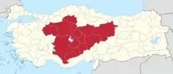
Central Anatolia Region
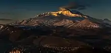
The Central Anatolia Region (Turkish: İç Anadolu Bölgesi) is a geographical region of Turkey. The largest city in the region is Ankara. Other big cities are Konya, Kayseri, Eskişehir and Sivas.

Central Anatolia Region
İç Anadolu Bölgesi | |
|---|---|
Region of Turkey | |
 | |
| Country | Turkey |
| Area | |
| • Total | 163,057 km2 (62,957 sq mi) |
| Population | |
| • Total | 12,896,255 |
Subdivisions
Ecoregions
Terrestrial
Palearctic
Palearctic regions include:
Temperate broadleaf and mixed forests
Temperate broadleaf and mixed forests include:
- Central Anatolian deciduous forests
- Eastern Anatolian deciduous forests
Temperate coniferous forests
Temperate coniferous forests are Northern Anatolian conifer and deciduous forests.
Temperate grasslands, savannas and shrublands
Central Anatolian steppe are classified as Temperate grasslands, savannas and shrublands.
Mediterranean forests, woodlands, and scrub
Mediterranean forests, woodlands, and scrub include:
- Anatolian conifer and deciduous mixed forests
- Southern Anatolian montane conifer and deciduous forests
Provinces


Provinces that are entirely in the Central Anatolia Region:
Provinces that are mostly in the Central Anatolia Region:
Provinces that are partially in the Central Anatolia Region:
Climate
Central Anatolia has a semi-arid continental climate with hot, dry summers and cold, snowy winters. Most of the region usually has low precipitation throughout the year.
| Sivas | ||||||||||||||||||||||||||||||||||||||||||||||||||||||||||||
|---|---|---|---|---|---|---|---|---|---|---|---|---|---|---|---|---|---|---|---|---|---|---|---|---|---|---|---|---|---|---|---|---|---|---|---|---|---|---|---|---|---|---|---|---|---|---|---|---|---|---|---|---|---|---|---|---|---|---|---|---|
| Climate chart (explanation) | ||||||||||||||||||||||||||||||||||||||||||||||||||||||||||||
| ||||||||||||||||||||||||||||||||||||||||||||||||||||||||||||
| ||||||||||||||||||||||||||||||||||||||||||||||||||||||||||||
See also
References
- "İl ve İlçelerimize Ait İstatistiki Veriler- Meteoroloji Genel Müdürlüğü". Archived from the original on 2011-06-20. Retrieved 2011-05-31.
External links
 Central Anatolia travel guide from Wikivoyage
| ||