Konya Province
Konya Province (Turkish: Konya ili), in southwest Central Anatolia, is the largest province of Turkey. The provincial capital is the city of Konya. Its traffic code is 42.
Konya Province
Konya ili | |
|---|---|
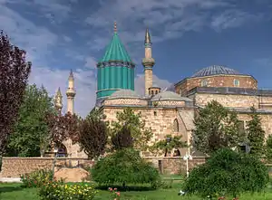 Mevlâna Museum in Konya | |
 Location of Konya Province in Turkey | |
| Country | Turkey |
| Region | West Anatolia |
| Subregion | Konya |
| Largest City | Konya |
| Government | |
| • Electoral district | Konya |
| • Governor | Vahdettin Özkan |
| Area | |
| • Total | 38,873 km2 (15,009 sq mi) |
| Population (2021)[2] | |
| • Total | 2,277,017 |
| • Density | 59/km2 (150/sq mi) |
| Area code | 0332 |
| Vehicle registration | 42 |
The Kızılören solar power plant in Konya will be able to produce 22.5 megawatts of electricity over an area of 430,000 square meters.[3]


Demographics
In 2011 the Konya Metropolitan Municipality had a population close to 1.1 million, out of the 2 million in the Konya Province (76.2% of the population in Konya Province lives in the city, while the remainder live in the villages, sub-districts and districts.)
| Year | Pop. | ±% p.a. |
|---|---|---|
| 1927 | 504,384 | — |
| 1935 | 569,684 | +1.53% |
| 1940 | 620,936 | +1.74% |
| 1950 | 741,026 | +1.78% |
| 1960 | 982,422 | +2.86% |
| 1970 | 1,280,239 | +2.68% |
| 1980 | 1,562,139 | +2.01% |
| 1990 | 1,750,303 | +1.14% |
| 2000 | 2,192,166 | +2.28% |
| 2010 | 2,013,845 | −0.84% |
| 2020 | 2,250,020 | +1.12% |
| Source:Turkstat[4][5][6] | ||
Divisions
The province of Konya is divided into thirty-one districts three of which (Meram, Selçuklu and Karatay) form part of Konya city.
- Ahırlı
- Akören
- Akşehir
- Altınekin
- Beyşehir
- Bozkır
- Çeltik
- Cihanbeyli
- Çumra
- Derbent
- Derebucak
- Doğanhisar
- Emirgazi
- Ereğli
- Güneysınır
- Hadim
- Halkapınar
- Hüyük
- Ilgın
- Kadınhanı
- Karapınar
- Karatay
- Kulu
- Meram
- Sarayönü
- Selçuklu
- Seydişehir
- Taşkent
- Tuzlukçu
- Yalıhüyük
- Yunak

The following districts are located in the Mediterranean Region: Ahırlı, Beyşehir, Bozkır, Derebucak, Hadim, Hüyük, Seydişehir, Taşkent, Yalıhüyük.
Lakes
Lake Tuz (Turkish: Tuz Gölü,) is the second largest lake in Turkey. It supplies much of the country's salt needs.
Beysehir Lake is on the western side of Konya province in a national park. It is the largest freshwater lake in Turkey and is important for local tourism, attracting thousands of people to its two beaches and twenty-two islands each year.
Caves
The following caves are in the province of Konya:[8]
- Balatini Cave, Beyşehir
- Büyü Düden Cave, Derebucak
- Körükini Cave, Beyşehir
- Tınaztepe Caves, Seydişehir
See also
- Konya Province, Ottoman Empire
- Blue Tunnel Project
References
- "Konya (Metropolitan Province, Turkey) - Population Statistics, Charts, Map and Location". citypopulation.de. Retrieved 19 August 2022.
- "Population of provinces by years - 2000-2018". Turkish Statistical Institute. Retrieved 9 March 2019.
- Company opens Turkey’s ‘largest solar power plant’ in Central Anatolia
- Genel Nüfus Sayımları
- Turkstat
- "The Results of Address Based Population Registration System, 2020". Turkish Statistical Institute. Archived from the original on 2021-10-28. Retrieved 7 December 2021.
- Türkiye Nüfus Sayimlarinda Azinliklar. August 2000. Retrieved 16 December 2018.
- "Konya Mağaraları" (in Turkish). Kültür ve Turizm Bakanlığı - Yatırım ve İşletmeler Genel Müdürlüğü. Retrieved 2017-01-26.
External links
| Districts |
| 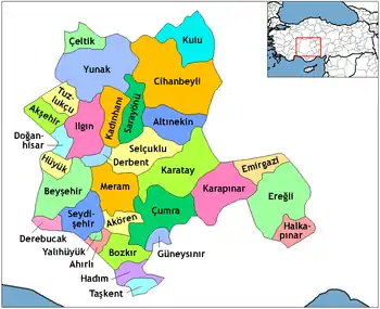 Districts of Konya | |||||||||||||||||||||||||
|---|---|---|---|---|---|---|---|---|---|---|---|---|---|---|---|---|---|---|---|---|---|---|---|---|---|---|---|
| |||||||||||||||||||||||||||
Metropolitan municipalities are bolded. | |||||||||||||||||||||||||||