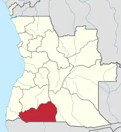
Cunene Province
Cunene is a province of Angola. It has an area of 87,342 km2 and a population of 990,087 in 2014.[1]
Cunene | |
|---|---|
 | |
| Country | |
| Capital | Ondjiva |
| Government | |
| • Governor | Vigílio da Ressurreição Bernardo Adriano Tyova |
| • Vice-Governor for the Political, Economic and Social Sector | Albertina Teresa José |
| • Vice-Governor for Technical Services and Infrastructures | Feliciano Salomão Himulova |
| Area | |
| • Total | 87,342 km2 (33,723 sq mi) |
| Population (2014 census)[1] | |
| • Total | 990,087 |
| Time zone | UTC+1 (WAT) |
| Area code | 035 |
| ISO 3166 code | AO-CNN |
| HDI (2018) | 0.509[2] low · 14th |
| Website | www |
Ondjiva is the capital of the province; it was previously known as Vila Pereira d’Eça. Ondjiva is the only city in this province. The distance from Ondjiva to Luanda is 1424 km and to Lubango is 415 km. The Cunene River gave its name to the province.
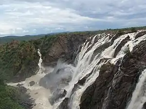
Cunene lies north of the Cunene River, which forms the border between Angola and Namibia. Cunene is traversed by the northwesterly line of equal latitude and longitude.
During World War I the region was the scene of fighting in 1914–15. The German campaign in Angola resulted in Germany's temporary occupation of the area.
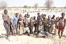
The inhabitants of the Province are overwhelmingly Ovambo pastoralists. Since the 1960s, they have been under pressure first from white settlers, and after independence from high-ranking military officers and politicians, who acquired large extensions of land which the Ovambo need for the transhumance of their cattle. The ecological, economic and social advantage of pastoralism over ranching has been known since the 1970s, but has not been sufficiently taken into account in policy making.[3]
Municipalities
The province of Cunene contains six municipalities (Portuguese: municípios):
- Cahama
- Kuroka (Curoca)
- Kuvelai (Cuvelai)
- Kwanhama (Cuanhama)
- Namakunde (Namacunde)
- Ombadja
Communes
The province of Cunene contains the following communes (Portuguese: comunas); sorted by their respective municipalities:
- Cahama Municipality: – Cahama, Oxinjau (Otchinjau)
- Kuroka Municipality: – Chitado, Oncócua
- Kuvelai Municipality: – Calonga, Cuvati (Cubati), Mucolongodijo (Mukolongodjo), Mupa (Omunda)
- Kwanhama Municipality: – Evale, Môngua, Nehone-Cafima, Ondjiva, Simporo (Tchimporo-Yonde)
- Namakunde Municipality: – Melunga-Chiede, Namakunde (Namacunde)
- Ombadja Municipality: – Humbe, Mucope, Naulila, Ombala yo Mungu, Xangongo
List of governors of Cunene
| Name | Years in office |
|---|---|
| Kundi Paihama | 1976–1979 |
| Capt Ary da Costa | 1979–1982 |
| Pedro Mutindi | 1983–2008 |
| António Didalelwa | 2008–2016 |
| Kundi Paihama | 2016–2018 |
| Vigílio da Ressurreição Bernardo Adriano Tyova | 2018–2020 |
| Gerdina Ulipamue Didalelwa | 2020– |
Up to 1991, the official name was Provincial Commissioner.
In popular culture
In Call of Duty: Black Ops II, UNITA under Jonas Savimbi assists Alex Mason and Jason Hudson to find the CIA remnants under Woods held by the MPLA and the Cubans.
See also
- Kunene Region in Namibia
References
- "Resultados Definitivos Recenseamento Geral da População e Habitação - 2014" (PDF). Instituto Nacional de Estatística, República de Angola. Archived from the original (PDF) on 14 December 2019. Retrieved 3 May 2020.
- "Sub-national HDI - Area Database - Global Data Lab". hdi.globaldatalab.org. Retrieved 2020-02-27.
- See Eduardo Cruz de Carvalho, "'Traditional' and 'Modern' Patterns of Cattle Raising in Southwestern Angola: A critical evaluation of change from Pastoralism to Ranching", The Journal of Developing Areas, 8 1974, pp. 199-226 http://www.the-eis.com/data/literature/Pastoralism%20in%20southern%20Angola.pdf
- "Virgílio Tyova é o 6º governador na história do Cunene" (in Portuguese). ANGOP Angolan State News Agency. 12 Sep 2018. Retrieved 5 Mar 2019.
External links
- Official website of province governor
- Information on this province at the Angolan ministry for territorial administration
- Information on this province at Info Angola
- Province geographical info at geoview.info
Capital: Ondjiva | |
| Cahama |
|
| Cuanhama |
|
| Curoca |
|
| Cuvelai |
|
| Namacunde |
|
| Ombadja |
|