Provinces of Afghanistan
Afghanistan is divided into 34 provinces (ولايت, wilåyat). The provinces of Afghanistan are the primary administrative divisions. Each province encompasses a number of districts or usually over 1,000 villages.
| Provinces of Afghanistan | |
|---|---|
| |
 | |
| Category | Unitary state |
| Location | Afghanistan |
| Number | 34 provinces |
| Populations | 147,964 (Nuristan) – 4,372,977 (Kabul) |
| Areas | 737 sq mi (1,908 km2) (Kapisa) – 22,512 sq mi (58,305 km2) (Helmand) |
| Government |
|
| Subdivisions |
|
Provincial governors played a critical role in the reconstruction of the Afghan state following the creation of the new government under Hamid Karzai.[1] According to international security scholar Dipali Mukhopadhyay, many of the provincial governors of the western-backed government were former warlords who were incorporated into the political system.[1]
Provinces of Afghanistan
Politics of Afghanistan |
|---|
|
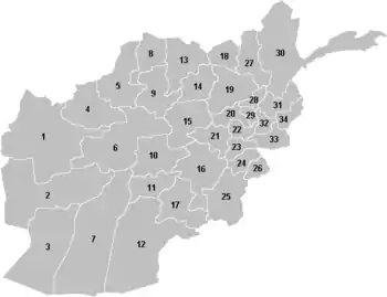
| Province | Map # | ISO 3166-2:AF[3] | License Plate Code |
Capital | Area (km2) |
Population (2015)[4] |
Population (2020)[5] |
Population density (per km2 in 2020)[6] |
No. of Districts |
U.N. Region | Region |
|---|---|---|---|---|---|---|---|---|---|---|---|
| Badakhshan | 30 | AF-BDS | BDN | Fayzabad | 44,836 | 950,953 | 1,054,100 | 23.5 | 29 | North East | North |
| Badghis | 4 | AF-BDG | BDG | Qala i Naw | 20,794 | 495,958 | 549,600 | 26.4 | 7 | West | Central |
| Baghlan | 19 | AF-BGL | BAG | Puli Khumri | 18,255 | 910,784 | 1,014,600 | 55.6 | 16 | North East | North |
| Balkh | 13 | AF-BAL | BLH | Mazar-i-Sharif | 16,186 | 1,325,659 | 1,509,200 | 93.2 | 15 | North West | North |
| Bamyan | 15 | AF-BAM | BAM | Bamyan | 18,029 | 487,218 | 495,600 | 27.5 | 7 | West | Central |
| Daykundi | 10 | AF-DAY | DYK | Nili | 17,501 | 507,339 | 516,500 | 29.5 | 8 | South West | South |
| Farah | 2 | AF-FRA | FRH | Farah | 49,339 | 507,405 | 563,000 | 11.4 | 11 | West | Central |
| Faryab | 5 | AF-FYB | FYB | Maymana | 20,798 | 998,147 | 1,109,200 | 53.3 | 14 | North West | North |
| Ghazni | 16 | AF-GHA | GAZ | Ghazni | 22,460 | 1,228,831 | 1,362,500 | 60.7 | 19 | South East | South |
| Ghor | 6 | AF-GHO | GHR | Chaghcharan | 36,657 | 790,296 | 764,500 | 20.9 | 11 | West | Central |
| Helmand | 7 | AF-HEL | HEL | Lashkargah | 58,305 | 924,711 | 1,446,200 | 24.8 | 13 | South West | South |
| Herat | 1 | AF-HER | HRT | Herat | 55,868 | 1,890,202 | 2,140,700 | 38.3 | 15 | West | Central |
| Jowzjan | 8 | AF-JOW | JZJ | Sheberghan | 11,292 | 540,255 | 602,100 | 53.3 | 9 | North West | North |
| Kabul | 22 | AF-KAB | KBL | Kabul | 4,524 | 4,372,977 | 5,204,700 | 1,150.5 | 18 | Central | Central |
| Kandahar | 12 | AF-KAN | KRD | Kandahar | 54,844 | 1,226,593 | 1,399,600 | 25.5 | 16 | South West | South |
| Kapisa | 29 | AF-KAP | KPS | Mahmud-i-Raqi | 1,908 | 441,010 | 488,300 | 255.9 | 7 | Central | Central |
| Khost | 26 | AF-KHO | KST | Khost | 4,235 | 574,582 | 636,500 | 150.3 | 13 | South East | South |
| Kunar | 34 | AF-KNR | KNR | Asadabad | 4,926 | 450,652 | 499,400 | 101.4 | 15 | East | Central |
| Kunduz | 18 | AF-KDZ | KDZ | Kunduz | 8,081 | 1,010,037 | 1,136,700 | 140.7 | 7 | North East | North |
| Laghman | 32 | AF-LAG | LGM | Mihtarlam | 3,978 | 445,588 | 493,500 | 124.1 | 5 | East | Central |
| Logar | 23 | AF-LOG | LGR | Pul-i-Alam | 4,568 | 392,045 | 434,400 | 95.1 | 7 | Central | Central |
| Nangarhar | 33 | AF-NAN | NGR | Jalalabad | 7,641 | 1,517,388 | 1,701,700 | 222.7 | 23 | East | Central |
| Nimruz | 3 | AF-NIM | NRZ | Zaranj | 42,410 | 164,978 | 183,600 | 4.3 | 5 | South West | South |
| Nuristan | 31 | AF-NUR | NUR | Parun | 9,267 | 147,967 | 163,800 | 17.7 | 7 | East | Central |
| Paktia | 24 | AF-PIA | PAK | Gardez | 5,583 | 551,987 | 612,000 | 109.6 | 11 | South East | South |
| Paktika | 25 | AF-PKA | PKT | Sharana | 19,516 | 434,742 | 775,500 | 39.7 | 15 | South East | South |
| Panjshir | 28 | AF-PAN | PJR | Bazarak | 3,772 | 371,902 | 169,900 | 45.0 | 7 | Central | Central |
| Parwan | 20 | AF-PAR | PRN | Charikar | 5,715 | 664,502 | 737,700 | 129.1 | 9 | Central | Central |
| Samangan | 14 | AF-SAM | SAM | Samangan | 13,438 | 387,928 | 430,500 | 32.0 | 5 | North West | North |
| Sar-e Pol | 9 | AF-SAR | SRP | Sar-e Pol | 16,386 | 559,577 | 621,000 | 37.9 | 7 | North West | North |
| Takhar | 27 | AF-TAK | TAK | Taloqan | 12,458 | 983,336 | 1,093,100 | 87.7 | 16 | North East | North |
| Uruzgan | 11 | AF-URU | ORZ | Tarinkot | 11,474 | 386,818 | 436,100 | 38.0 | 6 | South West | South |
| Wardak | 21 | AF-WAR | WDK | Maidan Shar | 10,348 | 596,287 | 660,300 | 63.8 | 9 | Central | Central |
| Zabul | 17 | AF-ZAB | ZBL | Qalat | 17,472 | 304,126 | 384,300 | 22.0 | 9 | South West | South |
Regions of Afghanistan
| Region | Area (km2) |
Population (2015)[7] |
Population (2020)[8] |
Population density (per km2 in 2020)[9] |
|---|---|---|---|---|
| Central | 237,334 | 13,571,397 | 15,067,100 | 63.4 |
| North | 161,730 | 7,666,676 | 8,570,500 | 52.9 |
| South | 253,800 | 6,304,707 | 7,752,800 | 30.5 |
UN Regions
| Region | Area (km2) |
Population (2015)[10] |
Population (2020)[11] |
Population density (per km2 in 2020)[12] |
|---|---|---|---|---|
| Central | 30,835 | 6,838,723 | 7,695,300 | 249.5 |
| East | 25,812 | 2,561,595 | 2,858,400 | 110.7 |
| North East | 83,630 | 3,855,110 | 4,298,500 | 51.3 |
| North West | 78,100 | 3,811,566 | 4,272,000 | 54.6 |
| South East | 51,794 | 2,790,142 | 3,386,500 | 65.3 |
| South West | 202,006 | 3,514,565 | 4,366,300 | 21.6 |
| West | 180,687 | 4,171,079 | 4,513,400 | 24.9 |
Former provinces of Afghanistan
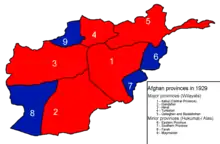
During Afghanistan's history it had a number of provinces in it. It started out as just Kabul, Herat, Qandahar, and Balkh but the number of provinces increased and by 1880 the provinces consisted of Balkh, Herat, Qandahar, Ghazni, Jalalabad, and Kabul.[13]
- Southern Province – dissolved in 1964 to create Paktia Province.
- Turkestan Province – dissolved somewhere between 1929 and 1946.
- Qataghan-Badakhshan Province – dissolved in 1963 into Badakhshan Province and Qataghan Province, the latter of which was also dissolved that same year.
- Qataghan Province – dissolved in 1963 into Baghlan Province, Kunduz Province, and Takhar Province.
- Eastern Province – dissolved in 1964 to create Nangarhar Province.
- Farah-Chakansur Province – dissolved in 1964 into Farah Province and Nimruz Province.
- Mazar-i-Sharif Province – dissolved in 1964 into Balkh Province and Jowzjan Province.
- Meymaneh Province – dissolved in 1964 into Badghis Province and Faryab Province.
See also
- List of current provincial governors in Afghanistan
- Districts of Afghanistan
Notes
- The territory is controlled by the Taliban-led government of the Islamic Emirate of Afghanistan, which is not recognized by any country. The international community considers the Islamic Republic of Afghanistan as the legitimate government of Afghanistan.
References
- Mukhopadhyay, Dipali (2014). "Building a Theory of Strongman Governance in Afghanistan". Warlords, Strongman Governors, and the State in Afghanistan. p. 43. doi:10.1017/cbo9781139161817.001. ISBN 9781139161817.
- Afghan school books - Geography G-12, Page 22-23 (in Persian) https://moe.gov.af/sites/default/files/2020-03/G12-Dr-Geography.pdf
- ISO 3166-2:AF (ISO 3166-2 codes for the provinces of Afghanistan)
- "registered through Argeweb". www.geohive.com.
- Central Statistics Office Afghanistan (web).
- "Afghanistan: Province Dashboard". World Bank.
- "registered through Argeweb". www.geohive.com.
- Central Statistics Office Afghanistan (web).
- "Afghanistan: Province Dashboard". World Bank.
- "registered through Argeweb". www.geohive.com.
- Central Statistics Office Afghanistan (web).
- "Afghanistan: Province Dashboard". World Bank.
- Andrew, W. P. (1880). Our Scientific Frontier.