Xian de Rutog
Le xian de Rutog (tibétain : རུ་ཐོག་རྫོང་།, Wylie : ru thog rdzong, pinyin tibétain : Rutog ; chinois : 日土县 ; pinyin : ) est un comté ou district administratif de la préfecture de Ngari, région autonome du Tibet en Chine.
Pour les articles homonymes, voir Rutog.
| Rìtǔ Xiàn 日土县 རུ་ཐོག་རྫོང་། | |
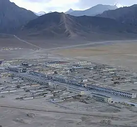
 La Communauté de Jieguosang (杰果桑社区) est le centre-administratif du bourg de Rutog[2], lui-même chef-lieu du comté | |
| Administration | |
|---|---|
| Pays | |
| Province ou région autonome | Tibet |
| Préfecture | Ngari |
| Statut administratif | Xian |
| Code postal | 859700[3] |
| Indicatif | +86 (0)897 |
| Démographie | |
| 9 738 hab. (2010) | |
| Densité | 0,13 hab./km2 |
| Géographie | |
| Coordonnées | 33° 54′ 48″ nord, 80° 45′ 01″ est |
| Superficie | 7 709 583 ha = 77 095,83 km2 |
| Localisation | |
.png.webp) Localisation du xian de Rutog (en rose) dans la préfecture de Ngari (en jaune) | |
| Liens | |
| Site web | www.xzrt.gov.cn |
Histoire
Pétroglyphes
Le bourg de Wujiang, dans le comté de Rutog, comporte des pétroglyphes appelés pétroglyphes de Takangba, datés d'une période allant de l'âge où l'on y fabriquait des outils en métal, à l'époque de l'introduction du bouddhisme au Tibet, au VIe siècle[4]. On y trouve notamment des peintures sur pierre[5],[6].
Démographie
La population du district est de 9 738 habitants en 2010[7].
Subdivisions administratives
Le xian comporte un bourg et quatre cantons (ou xiang)[8] :
- bourg de Rudok (日土镇, ) ;
- Canton de Rebang (zh) (热帮乡, ) ;
- Canton de Risong (zh) (日松乡, ) ;
- Canton de Dongru (zh) (东汝乡, ) ;
- Canton de Duoma (zh) (多玛乡, ).
Notes et références
- (zh) « 西藏阿里地区日土县日土镇杰果桑社区 », sur Yigecun
- (zh) « 西藏阿里地区日土县日土镇杰果桑社区 », sur Yigecun
- (en) Codes postaux et téléphoniques de la région autonome du Tibet, (en) China Zip Code/ Telephone Code, ChinaTravel.
- (en) « Surveys of Petroglyphs at Takangba in Rutog County, Tibet », 《Archaeology》, Archaeology Department, Sichuan University, no 6, (lire en ligne)
- (Zhang 1999)
- (Wangdu et Dhondup 2014)
- http://www.xzqh.org/html/show/xz/20230.html
- (zh) « 2017年统计用区划代码和城乡划分代码:日土县. », sur 中华人民共和国国家统计局,
Bibliographie
- (en) Donna L. Gillette Ph.D., Mavis Greer Ph.D. (auth.), Donna L. Gillette, Mavis Greer, Michele Helene Hayward, William Breen Murray (eds.), Rock Art and Sacred Landscapes, New York, année=2014, Springer-verla, coll. « One World Archaeology 8 » (ISBN 978-1-4614-8405-9)
- (en) Sonam Wangdu et Yeshi Dhondup, « A Report of the Archeological Research Done on the Tibetan Plateau and Conjectures about Future Developments », The Tibet Journal, Library of Tibetan Works and Archives, vol. 35, no 3, , p. 41-59 (lire en ligne)
- (en) Zhang Yasha, « A tentative analysis on Chu Garbyang Rock paintings in Ruthog County of Ngari District : Discussing the related problem between rock paintings and Sumpi . China », Tibetology, no 2, , p. 56–59
- (en) Zhang Yasha, « Pagoda - shaped pictures in Tibetan rock art », China Tibetology, no 2,
- Portail du Tibet
- Portail de la Chine
Cet article est issu de Wikipedia. Le texte est sous licence Creative Commons - Attribution - Partage dans les Mêmes. Des conditions supplémentaires peuvent s'appliquer aux fichiers multimédias.

