1967 St. Louis tornado outbreak
An extremely rare wintertime tornado outbreak affected the Midwestern United States on January 24, 1967. Of the 30 confirmed tornadoes, 13 occurred in Iowa, nine in Missouri, seven in Illinois, and one in Wisconsin. The outbreak produced, at the time, the northernmost tornado to hit the United States in winter, in Wisconsin, until January 7, 2008. The tornadoes formed ahead of a deep storm system in which several temperature records were broken. The deadliest and most damaging tornado of the outbreak struck Greater St. Louis at F4 intensity, killing three people and injuring 216.[nb 1][nb 2][nb 3]
 Path of the F4 tornado in St. Louis | |
| Type | Tornado outbreak |
|---|---|
| Duration | January 24, 1967 |
| Tornadoes confirmed | 30 |
| Max. rating1 | F4 tornado |
| Duration of tornado outbreak2 | 8 hours, 50 minutes |
| Fatalities | 7 fatalities, 268 injuries |
| Damage | Unknown |
| Areas affected | Missouri, Illinois, Iowa, Wisconsin |
Part of the tornadoes and tornado outbreaks of 1967 1Most severe tornado damage; see Fujita scale 2Time from first tornado to last tornado | |
Background

On Tuesday, January 24, 1967, a negatively tilted trough bisected the Midwestern United States. As a cold front traversed the Upper Midwest, a line of intermittent, tornado-producing supercells developed.[10]
Impact
Confirmed tornadoes
| FU | F0 | F1 | F2 | F3 | F4 | F5 | Total |
|---|---|---|---|---|---|---|---|
| 0 | 3 | 4 | 15 | 6 | 2 | 0 | 30* |
- Along with the 30 confirmed tornadoes listed, tornado researcher Thomas P. Grazulis listed two additional F2 tornadoes that may have touched down.
- The first occurred west of Muscatine, Muscatine County, Iowa, at 22:30 UTC, unroofing and tearing apart a house. It was officially listed as a severe thunderstorm wind in Storm Data.[11]
- The other occurred on the southern outskirts of Illinois City, Rock Island County, Illinois, at an unknown time, damaging homes before ripping the roof off a farmhouse. It was officially listed as part of a complex of severe thunderstorm winds in Storm Data.[12]
| F# | Location | County / Parish | State | Start coord. |
Time (UTC) | Path length | Max. width | Summary |
|---|---|---|---|---|---|---|---|---|
| F2 | N of De Kalb to SSE of Lake Station | Buchanan | MO | 39.60°N 94.93°W | 17:50–? | 6.1 miles (9.8 km) | 100 yards (91 m) | This strong tornado affected 12 or more farmsteads. It destroyed a concrete barn, along with assorted outbuildings and other barns. Homes lost their roofs, along with some walls. Losses totaled $250,000.[14][15][16] |
| F2 | E of Haynesville to S of Barnesville | Clinton | MO | 39.45°N 94.23°W | 18:35–? | 2.5 miles (4.0 km) | 50 yards (46 m) | This strong but relatively brief tornado developed 1 mi (1.6 km) west of the junction of Missouri Supplemental Route PP and U.S. Route 69. As it headed northeast, it struck five farmsteads, extensively damaging outbuildings on a few of them. Losses totaled $25,000. Tornado researcher Thomas P. Grazulis did not list the tornado as an F2 or stronger.[17][18][16] |
| F3 | SSE of Lake City to Northwestern Buckner to NE of Albany | Jackson, Ray | MO | 39.10°N 94.25°W | 18:40–19:00 | 14.5 miles (23.3 km) | 200 yards (180 m) | 2 deaths – This intense tornado first developed over the Lake City Army Ammunition Plant, 3 mi (4.8 km) from Buckner. Tracking northeastward, it first produced a narrow, spasmodic swath of structural damage, skirting Buckner and passing east of Sibley. As it neared Orrick, the tornado widened and intensified, striking Orrick High School while at maximum intensity. Part of a roof at the school collapsed, killing two students underneath. Two homes were destroyed and another lost its second story. Barns and outbuildings were leveled along the path. 18 people were injured and losses totaled $5 million.[14][19][20][16] |
| F0 | SE of Polo | Caldwell | MO | 39.55°N 94.05°W | 18:50–? | 2 miles (3.2 km) | 100 yards (91 m) | Losses totaled $25,000.[21][16] |
| F0 | E of Sturges | Livingston | MO | 39.88°N 93.48°W | 20:00–? | 0.1 miles (0.16 km) | 10 yards (9.1 m) | Losses totaled $30.[22][16] |
| F1 | W of Green City to N of Pennville | Sullivan | MO | 40.27°N 93.02°W | 20:20–? | 7.3 miles (11.7 km) | 50 yards (46 m) | This tornado wrecked a number of outbuildings and a barn. Losses totaled $25,000. Grazulis listed the tornado as an F2.[14][23][16] |
| F1 | Glendale to NW of Livonia | Putnam | MO | 40.48°N 92.77°W | 20:45–? | 2.5 miles (4.0 km) | 50 yards (46 m) | Moving generally northeastward, this tornado developed near the junction of Missouri Route 149 and U.S. Route 136. Losses totaled $2,500.[24][16] |
| F4 | ESE of Queen City, MO to ESE of Pulaski, IA | Schuyler (MO), Scotland (MO), Davis (IA) | MO, IA | 40.40°N 92.53°W | 20:45–? | 25.7 miles (41.4 km) | 440 yards (400 m) | This violent tornado damaged or destroyed numerous outbuildings and barns on 24 farmsteads. Five of the farmsteads were destroyed, two of which had every structure leveled, including the farmhouse. A total of approximately 20 other farms were damaged as well. Two people were injured and losses totaled $2,525,000. Most of the path and the F4-level damage were in Missouri. Only a 2-mile-long (3.2 km) segment continued into Iowa, with F1-level damage.[14][25][26][27] |
| F3 | S of Douds to E of Fairfield | Van Buren, Jefferson | IA | 40.87°N 92.08°W | 21:15–? | 25 miles (40 km) | 400 yards (370 m) | This intense tornado produced sporadic damage. It badly damaged several homes, some of which lost roofs and walls. Barns and outbuildings were destroyed as well. Losses totaled $250,000. Grazulis listed the tornado as an F2. The NCEI only lists a single coordinate, north of Douds.[14][28][29] |
| F1 | Western Washington | Washington | IA | 41.30°N 91.70°W | 21:45–? | 1 mile (1.6 km) | 200 yards (180 m) | Losses totaled $2,500.[30][29] |
| F0 | N of Winfield | Henry | IA | 41.15°N 91.43°W | 21:50–? | 0.1 miles (0.16 km) | 150 yards (140 m) | Losses totaled $250,000.[31][29] |
| F2 | SW of Columbus City | Louisa | IA | 41.30°N 91.37°W | 22:00–? | 3 miles (4.8 km) | 250 yards (230 m) | Losses totaled $30. Grazulis did not list the tornado as an F2 or stronger. The NCEI lists the path as occurring north of Fredonia and extending into Muscatine County.[17][32][29] |
| F3 | N of Fort Madison to S of Wever (1st tornado) | Lee | IA | 40.67°N 91.32°W | 22:15–? | 4.3 miles (6.9 km) | 300 yards (270 m) | 1 death – This intense tornado destroyed a pair of homes, one of which only had a single wall left standing. Six people were injured and losses totaled $250,000.[14][33][29] |
| F2 | S of Wever (2nd tornado) to N of Skunk River | Lee | IA | 40.70°N 91.23°W | 22:20–? | 3 miles (4.8 km) | 200 yards (180 m) | This strong tornado crossed the Skunk River near Wever. Homes had their roofs torn off and barns were wrecked. Trailers were destroyed as well, injuring four people. Losses totaled $250,000.[14][34][29] |
| F2 | ENE of Cairo | Louisa | IA | 41.20°N 91.28°W | 22:20–? | 2 miles (3.2 km) | 150 yards (140 m) | This strong tornado tore loose a wall from a house and tossed an automobile against the home. A nearby barn was destroyed as well. One person was injured and losses totaled $25,000.[14][35][29] |
| F2 | ESE of Gladstone to W of Reeds | Henderson | IL | 40.85°N 90.93°W | 22:40–22:50 | 5.7 miles (9.2 km) | 77 yards (70 m) | This tornado, while mostly affecting treetops, unroofed or otherwise damaged many outbuildings and barns. At least one barn was flattened, six utility poles splintered, and a farm shorn of all its outbuildings. Losses totaled $25,000. The tornado passed north of Biggsville.[14][36][37] |
| F2 | S of Wheatland | Clinton | IA | 41.80°N 90.83°W | 22:45–? | 2 miles (3.2 km) | 150 yards (140 m) | Losses totaled $25,000. Grazulis did not list the tornado as an F2 or stronger.[17][38][29] |
| F2 | NNE of Dixon | Clinton | IA | 41.78°N 90.77°W | 22:50–? | 2 miles (3.2 km) | 143 yards (131 m) | Losses totaled $25,000. Grazulis did not list the tornado as an F2 or stronger. Storm Data indicates that the tornado occurred near Calamus.[17][39][29] |
| F2 | Southern Eldridge | Scott | IA | 41.62°N 90.58°W | 23:11–? | 2 miles (3.2 km) | 250 yards (230 m) | This strong tornado touched down just west of Mount Joy. It hurled an automobile and a truck from a roadway. Homes sustained breakage of their windows and barns were wrecked. Losses totaled $250,000.[14][40][29] |
| F2 | NW of Elvira | Clinton | IA | 41.87°N 90.37°W | 23:15–? | 1 mile (1.6 km) | 200 yards (180 m) | Losses totaled $25,000. Grazulis did not list the tornado as an F2 or stronger.[17][41][29] |
| F2 | NE of Tenmile | Clinton | IA | 41.95°N 90.33°W | 23:15–? | 0.1 miles (0.16 km) | 100 yards (91 m) | Several barns, a warehouse, and a Granger Hall were destroyed. Homes nearby had their roofs torn off. Losses totaled $250,000. The tornado may have developed near Bryant. Storm Data listed a 5-mile-long (8.0 km) path.[14][42][29] |
| F3 | E of Burke to NE of Mount Carroll | Carroll | IL | 42.05°N 90.03°W | 23:30–? | 7.4 miles (11.9 km) | 77 yards (70 m) | This intense tornado destroyed three homes on the northwestern side of Mount Carroll, one of which it impacted at borderline-F4 intensity. Roofing, outbuildings, and barns incurred extensive damage as well. 12 people were injured and losses totaled $250,000. Grazulis listed the time of occurrence as 22:40 UTC.[14][43][37] |
| F1 | WSW of Saidora to NNE of White City | Mason | IL | 40.10°N 90.17°W | 23:30–? | 4.5 miles (7.2 km) | 30 yards (27 m) | This tornado paralleled the following event, just 3 mi (4.8 km) away. Outbuildings, a hangar, and trees were destroyed or extensively damaged. An airplane was damaged as well. One person was injured. Losses were unknown. Storm Data attributed the sole injury to the next event.[14][44][37] |
| F3 | S of Snicarte to SE of Bluff City | Mason | IL | 40.12°N 90.22°W | 23:30–? | 5.1 miles (8.2 km) | 80 yards (73 m) | 1 death – This intense tornado destroyed rural homes and outbuildings. Three people were injured and losses totaled $25,000. The body of the dead was tossed 200 yd (600 ft). Storm Data stated that the path was only 1 mi (1.6 km) long.[14][45][37] |
| F3 | S of Brodhead to SE of Milton | Green, Rock | WI | 42.60°N 89.37°W | 00:10–00:40 | 24.9 miles (40.1 km) | 200 yards (180 m) | This intense but intermittent tornado wrecked a number of barns. A country club was stripped of its roof and a pair of walls as well. Losses totaled $250,000. Grazulis listed the tornado as an F2. At the time the tornado was the northernmost wintertime tornado on record in the contiguous United States.[17][46][37] |
| F2 | ENE of Cooper to WSW of Cruger | Tazewell, Woodford | IL | 40.67°N 89.38°W | 00:30–? | 3.3 miles (5.3 km) | 77 yards (70 m) | This strong tornado snapped and felled trees. Roofing and outbuildings were damaged as well. Losses totaled $2,500. Grazulis did not list the tornado as an F2 or stronger.[17][47][37] |
| F2 | S of Virden | Macoupin | IL | 39.48°N 89.77°W | 00:50–? | 2.5 miles (4.0 km) | 100 yards (91 m) | This tornado flipped a home upside down and shifted another. In all about 100 homes were damaged to varying degrees. Most of the damage was to roofing or from fallen trees. Several trailers were damaged as well, and a few grain bins were moved 200–440 yd (600–1,320 ft). Losses totaled $250,000. Grazulis did not list the tornado as an F2 or stronger.[17][48][37] |
| F2 | NW of Metamora | Woodford | IL | 00:50– | 2.5 miles (4.0 km) | |||
| F4 | NE of Chesterfield to NE of Spanish Lake | St. Louis | MO | 00:55– | 25 miles (40 km) | 3 deaths – See section on this tornado | ||
| F2 | Champaign–Urbana | Champaign | IL | 02:40– | 10.4 miles (16.7 km) | A trailer was destroyed and scattered, two others were overturned, and two more were damaged. One house had its roof torn off. |
Northern Chesterfield–Maryland Heights–St. Ann–Lambert Field–Spanish Lake, Missouri
| F4 tornado | |
|---|---|
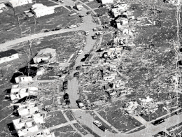 Aerial view of damage in Chesterfield, Missouri, after the F4 tornado of January 24, 1967 | |
| Max. rating1 | F4 tornado |
| Fatalities | 3 fatalities, 216 injuries |
| Damage | $25,000,000 (1967 USD) $219 million (2023 USD) |
| 1Most severe tornado damage; see Fujita scale | |
Tornado moved through the St. Louis suburbs striking Maryland Heights, St.Ann, Lambert Field, and Spanish Lake. 168 homes were destroyed and 1740 others were damaged. Some of the homes were leveled. A nursing home was also badly damaged.[49]
See also
- List of tornadoes and tornado outbreaks
- List of tornado-related deaths at schools
- Tornado outbreak of January 2008 – Similar rare tornado outbreak in January in the Midwest
Notes
- An outbreak is generally defined as a group of at least six tornadoes (the number sometimes varies slightly according to local climatology) with no more than a six-hour gap between individual tornadoes. An outbreak sequence, prior to (after) the start of modern records in 1950, is defined as a period of no more than two (one) consecutive days without at least one significant (F2 or stronger) tornado.[1]
- The Fujita scale was devised under the aegis of scientist T. Theodore Fujita in the early 1970s. Prior to the advent of the scale in 1971, tornadoes in the United States were officially unrated.[2][3] While the Fujita scale has been superseded by the Enhanced Fujita scale in the U.S. since February 1, 2007,[4] Canada used the old scale until April 1, 2013;[5] nations elsewhere, like the United Kingdom, apply other classifications such as the TORRO scale.[6]
- Historically, the number of tornadoes globally and in the United States was and is likely underrepresented: research by Grazulis on annual tornado activity suggests that, as of 2001, only 53% of yearly U.S. tornadoes were officially recorded. Documentation of tornadoes outside the United States was historically less exhaustive, owing to the lack of monitors in many nations and, in some cases, to internal political controls on public information.[7] Most countries only recorded tornadoes that produced severe damage or loss of life.[8] Significant low biases in U.S. tornado counts likely occurred through the early 1990s, when advanced NEXRAD was first installed and the National Weather Service began comprehensively verifying tornado occurrences.[9]
- All dates are based on the local time zone where the tornado touched down; however, all times are in Coordinated Universal Time and dates are split at midnight CST/CDT for consistency.
- Prior to 1994, only the average widths of tornado paths were officially listed.[13]
References
- Schneider, Russell S.; Brooks, Harold E.; Schaefer, Joseph T. (2004). Tornado Outbreak Day Sequences: Historic Events and Climatology (1875–2003) (PDF). 22nd Conf. Severe Local Storms. Hyannis, Massachusetts: American Meteorological Society. Retrieved September 17, 2019.
- Grazulis 1993, p. 141.
- Grazulis 2001a, p. 131.
- Edwards, Roger (March 5, 2015). "Enhanced F Scale for Tornado Damage". The Online Tornado FAQ (by Roger Edwards, SPC). Storm Prediction Center. Retrieved February 25, 2016.
- "Enhanced Fujita Scale (EF-Scale)". Environment and Climate Change Canada. June 6, 2013. Archived from the original on March 3, 2016. Retrieved February 25, 2016.
- "The International Tornado Intensity Scale". Tornado and Storm Research Organisation. 2016. Archived from the original on March 5, 2016. Retrieved February 25, 2016.
- Grazulis 2001a, pp. 251–4.
- Edwards, Roger (March 5, 2015). "The Online Tornado FAQ (by Roger Edwards, SPC)". Storm Prediction Center: Frequently Asked Questions about Tornadoes. Storm Prediction Center. Retrieved February 25, 2016.
- Cook & Schaefer 2008, p. 3135.
- "Janurary [sic] 24, 1967 Tornado Outbreak". Quad Cities, IA/IL Weather Forecast Office. Davenport, Iowa: National Weather Service. Retrieved 4 October 2022.
- Multiple sources:
- Grazulis 1993, p. 1086
- Storm Data 1967, p. 2
- Multiple sources:
- Grazulis 1993, p. 1086
- Storm Data 1967, p. 7
- Brooks 2004, p. 310.
- Grazulis 1993, p. 1086.
- Storm Data Publication 1967, #10056784
- Storm Data 1967, p. 4.
- Grazulis 1993, pp. 1086–7.
- Storm Data Publication 1967, #10056790
- Storm Data Publication 1967, #10056791
- Storm Data Publication 1967, #10056793
- Storm Data Publication 1967, #10056792
- Storm Data Publication 1967, #10056795
- Storm Data Publication 1967, #10056796
- Storm Data Publication 1967, #10056797
- Storm Data Publication 1967, #10056798
- Storm Data Publication 1967, #10011998
- Storm Data 1967, pp. 2, 4.
- Storm Data Publication 1967, #10011999
- Storm Data 1967, p. 2.
- Storm Data Publication 1967, #10012000
- Storm Data Publication 1967, #10012001
- Storm Data Publication 1967, #10012002
- Storm Data Publication 1967, #10012003
- Storm Data Publication 1967, #10012004
- Storm Data Publication 1967, #10012005
- Storm Data Publication 1967, #10009966
- Storm Data 1967, p. 7.
- Storm Data Publication 1967, #10012006
- Storm Data Publication 1967, #10012007
- Storm Data Publication 1967, #10012008
- Storm Data Publication 1967, #10012009
- Storm Data Publication 1967, #10012010
- Storm Data Publication 1967, #10009969
- Storm Data Publication 1967, #10009968
- Storm Data Publication 1967, #10009970
- Storm Data Publication 1967, #10148040
- Storm Data Publication 1967, #10009973
- Storm Data Publication 1967, #10009974
- "January 24th 1967 F4 Tornado St. Louis County". St. Louis, MO Weather Forecast Office. St. Charles, Missouri: National Weather Service. Retrieved 4 October 2022.
Sources
- Brooks, Harold E. (April 2004). "On the Relationship of Tornado Path Length and Width to Intensity". Weather and Forecasting. Boston: American Meteorological Society. 19 (2): 310–19. Bibcode:2004WtFor..19..310B. doi:10.1175/1520-0434(2004)019<0310:OTROTP>2.0.CO;2.
- Cook, A. R.; Schaefer, J. T. (August 2008). Written at Norman, Oklahoma. "The Relation of El Niño–Southern Oscillation (ENSO) to Winter Tornado Outbreaks". Monthly Weather Review. Boston: American Meteorological Society. 136 (8): 3135. Bibcode:2008MWRv..136.3121C. doi:10.1175/2007MWR2171.1.
- Grazulis, Thomas P. (May 1984). Violent Tornado Climatography, 1880–1982. OSTI (Technical report). NUREG. Washington, D.C.: Nuclear Regulatory Commission. OSTI 7099491. CR-3670.
- Grazulis, Thomas P. (November 1990). Significant Tornadoes 1880–1989. Vol. 2. St. Johnsbury, Vermont: The Tornado Project of Environmental Films. ISBN 1-879362-02-3.
- Grazulis, Thomas P. (July 1993). Significant Tornadoes 1680–1991: A Chronology and Analysis of Events. St. Johnsbury, Vermont: The Tornado Project of Environmental Films. ISBN 1-879362-03-1.
- Grazulis, Thomas P. (2001a). The Tornado: Nature's Ultimate Windstorm. Norman: University of Oklahoma Press. ISBN 978-0-8061-3538-0.
- Grazulis, Thomas P. (2001b). F5-F6 Tornadoes. St. Johnsbury, Vermont: The Tornado Project of Environmental Films.
- National Weather Service (January 1967). Storm Data Publication (Report). National Centers for Environmental Information – via Storm Events Database.
- U.S. Weather Bureau (January 1967). "Storm Data and Unusual Weather Phenomena". Storm Data. Asheville, North Carolina: National Climatic Data Center. 9 (1).