Hurricane Norbert (2014)
Hurricane Norbert produced a 1-in-1,000 year rainfall event in Arizona in early September 2014. The fifteenth named storm, tenth hurricane, and seventh major hurricane of the 2014 Pacific hurricane season, Norbert originated from an area of disturbed weather in association with an area of low pressure on September 2. Tracking generally northwestward, the newly designated tropical storm steadily organized in a moderate shear environment. Norbert attained hurricane intensity early on September 4 and Category 2 hurricane strength the next afternoon. Thereafter, the cyclone began a period of rapid deepening, and it subsequently attained its peak intensity with winds of 125 mph (201 km/h) and a minimum pressure of 950 mbar (950 hPa; 28 inHg) early on September 6. A track over progressively cooler waters and into a more stable environment prompted a weakening trend after peak intensity, and by early on September 8, the system no longer maintained enough convection to be considered a tropical cyclone.
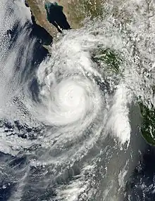
 Hurricane Norbert rapidly intensifying off the Baja California Peninsula on September 5 | |
| Meteorological history | |
|---|---|
| Formed | September 2, 2014 |
| Remnant low | September 8, 2014 |
| Dissipated | September 11, 2014 |
| Category 3 hurricane | |
| 1-minute sustained (SSHWS/NWS) | |
| Highest winds | 125 mph (205 km/h) |
| Lowest pressure | 950 mbar (hPa); 28.05 inHg |
| Overall effects | |
| Fatalities | 5 total |
| Damage | $28.3 million (2014 USD) |
| Areas affected | Western Mexico, Baja California Peninsula, Southwestern United States |
| IBTrACS | |
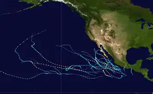
Part of the 2014 Pacific hurricane season | |
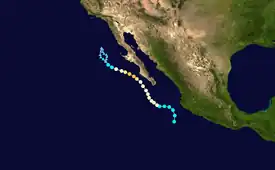
Meteorological history

Tropical storm (39–73 mph, 63–118 km/h)
Category 1 (74–95 mph, 119–153 km/h)
Category 2 (96–110 mph, 154–177 km/h)
Category 3 (111–129 mph, 178–208 km/h)
Category 4 (130–156 mph, 209–251 km/h)
Category 5 (≥157 mph, ≥252 km/h)
Unknown
On August 30, the National Hurricane Center (NHC) indicated the potential for an area of low pressure to form offshore the coastline of Mexico and slowly develop over subsequent days.[1] This projection came to fruition the next afternoon, when a large area of showers and thunderstorms in association with a trough of low pressure was noted.[2] Amid a generally favorable environment with moderate wind shear and warm sea surface temperatures, convection steadily coalesced atop a distinct low-level circulation, and the disturbance acquired enough organization to be deemed a tropical cyclone at 15:00 UTC on September 2; it was designated Tropical Storm Norbert in accordance with an Advanced Scatterometer (ASCAT) pass. Due to moderate northeasterly wind shear, only modest intensification was predicted.[3] Norbert moved generally northwestward succeeding formation, steered around the southwestern periphery of a subtropical ridge across Baja California and northern Mexico.[4] All the while, the cloud pattern of the cyclone progressively improved, with a symmetric central dense overcast and distinct rainbands on convectional satellite, and a formative inner core with hints of a small mid-level eye on hurricane imagery.[5] In conjunction with satellite intensity estimates, Norbert was upgraded to a Category 1 hurricane on September 4.[6]
.jpg.webp)
Continuing on a general northwestward trajectory, increased easterly wind shear caused the system to temporarily lose organization during the pre-dawn hours of September 4 as the low- and mid-level circulations became dislocated.[7] An Air Force Reserve Hurricane Hunter aircraft investigated Norbert that afternoon, recording peak flight-level winds of 97 mph (156 km/h), maximum surface winds of 90 mph (140 km/h), and a minimum barometric pressure of 970 mbar (970 hPa; 29 inHg).[8][9] Early on September 6, the cyclone began a period of unexpected rapid deepening; at 00:00 UTC, it was upgraded to a Category 2 hurricane,[10] and at 06:00 UTC, it intensified a major hurricane, a Category 3 hurricane on the Saffir-Simpson Hurricane Wind Scale.[11] After attaining its peak intensity with maximum winds of 125 mph (201 km/h) and a minimum pressure of 950 mbar (950 hPa; 28 inHg), Norbert began to track over cooler sea surface temperatures, and a weakening trend ensued. It was downgraded to a Category 2 hurricane at 21:00 UTC on September 6,[12] and further to a Category 1 hurricane at 03:00 UTC the next day.[13] Deep convection associated with Norbert began to wane significantly as the storm entered a stable environment, and a blend of satellite intensity estimates prompted the NHC to downgrade it to a tropical storm at 15:00 UTC.[14] At 09:00 UTC on September 8, after having been devoid of deep, organized convection for over 12 hours, the system was declared a post-tropical cyclone.[15] During the next few days, Nobert's remnants made a northward loop, before dissipating on September 11.[16]
Preparations
Despite remaining well offshore the Mexican coast, classes in Manzanillo were suspended for a day.[17] A "yellow" (moderate) alert was activated for Sinaloa, Nayarit, and Jalisco. Elsewhere, an "orange" (high) alert was issued for Soccoro Island, San Benedicto Island, and Baja California Sur.[18] The southern portions of the state of Sonora was placed under a "yellow" alert, while a green alert was declared for the northern portions.[19] The port of Guaymas was closed for small craft.[20] Along the Baja California Peninsula officials activated 900 emergency workers to assist in the supply of food and fuel. Additionally, 164 shelters were opened.[21] On September 5, the "orange" alert was upped to a "red" (maximum) alert.[22]
When the remnants of Norbert spread into the United States, local National Weather Service offices issued flash flood watches and warnings,[23] with watches posted across portions of California, Arizona, Nevada, Utah, and Colorado. Several schools in Arizona were closed or delayed due to flooding.[24]
Mexican impact
Roads surrounding Manzanillo were closed for three hours due to landslides. Further north, several homes in Jalisco were flooded.[25] In Nayarit, three people were evacuated to shelters.[19] A man died in Mazatlán, Sinaloa after being swept away by a swollen stream, and two women in Chihuahua drowned while driving across a flooded creek.[26] In Puerto San Carlos, a mudslide forced 425 people from two hotels to seek shelter.[27] A dam collapsed northwest of the city due to the rains, causing flooding 5 ft (1.5 m) deep in the town. The resultant floods damaged 2,500 homes and left about 2,500 people homeless, about one-third of its population.[26] Throughout the municipalities of La Paz, Los Cabos, and Comondu, 2,000 people were evacuated to shelters,[28] including 785 people in La Paz alone.[29] Throughout the peninsula, 500 were rendered as homeless.[30]
Southwestern United States flood event

The circulation of Norbert, in conjunction with the remnants of Atlantic Tropical Storm Dolly, spread moisture across northwest Mexico and into the southwestern United States.[13] Rainfall in southern California peaked at around 3 in (76 mm) in Hemet. The rains caused flooding along several freeways and other roads, stranding 70 cars along Route 74 near Mountain Center.[31] Near Palm Springs, over 40 travelers required rescue after their cars were flooded. One nearby school was evacuated.[24] Around 70 motorists got stuck on California State Route 74 due to flooding. Along the northern section of Riverside, many trees were toppled and power lines were knocked down. Almost all freeways across the Inland Empire were flooded.[32] Damage in the state amounted to $706,000 (USD).[33]

In Arizona, rainfall peaked at 6.09 in (155 mm) near Chandler. During a seven-hour period, Phoenix Sky Harbor Airport recorded 3.30 in (84 mm) of rainfall, breaking the 75‑year‑old daily rainfall record. It was also the highest precipitation in a single calendar day, but fell short of the station's 24‑hour rainfall total.[34] The rainfall was more than the city's average summer rainfall.[24] About one of every three Maricopa County rain gauges set all-time records.[35] Accumulations in Chandler and Mesa were deemed to be a 1-in-1,000 year event while Phoenix was calculated to be a 1-in-200 year event.[36] The floods covered several roads and highways, which closed portions of Interstates 17 and 10.[23] County-wide, 10,000 customers lost power.[37] In Mesa, residents from 100 homes were evacuated.[38] Two women died, one in Pinal County and one in Tucson; both were swept away by floodwaters in their vehicles. Waters in Tucson reached as deep as 15 ft (4.6 m).[39] In several locations, pumping stations were unable to handle the deluge. About 10,000 people lost power in the state. In response to the flooding, Governor Jan Brewer issued a state of emergency and ordered nonessential workers to remain at home.[23] Overall, the flooding was the worst to affect that state since 1970.[24] Total damage statewide amounted to $18 million.[40]
New Mexico Highway 152 suffered significant damage, with portions of the road washed away and debris covering large stretches of road. Due to the severity of damage, the New Mexico Department of Transportation closed the road indefinitely and stated it could be more than a month until it was re-opened.[41]
In Nevada, rainfall totaled over 4 in (100 mm) in a short period of time, causing the worst flooding in the Moapa Valley since 1981. The flooding prompted The National Weather Service to issue a strongly worded flash flood emergency for the Moapa Valley, advising people to avoid travel and keep local roads open for emergency operations.[42][43] The waters closed a 30 mi (48 km) section of Interstate 15 in both directions.[44] Several vehicles were washed away along the interstate and damaged the road forcing the closure for several days.[44] The cost of the repairs to the road are expected to be in excess of $5 million.[45] Indian Reservation in Moapa was evacuated due to the floods.[24] Up to 200 children were trapped in an elementary school due to waters 12 ft (3.7 m) deep.[46] Damage in the state amounted to $9.64 million.[47]
See also
References
- Eric S. Blake; Todd B. Kimberlain (August 30, 2014). "Tropical Weather Outlook". National Hurricane Center. Miami, Florida: National Oceanic and Atmospheric Administration. Retrieved September 7, 2014.
- Todd B. Kimberlain (August 31, 2014). "Tropical Weather Outlook". National Hurricane Center. Miami, Florida: National Oceanic and Atmospheric Administration. Retrieved September 7, 2014.
- Eric S. Blake (September 2, 2014). "Tropical Storm Norbert Discussion Number 1". National Hurricane Center. Miami, Florida: National Oceanic and Administration. Retrieved September 7, 2014.
- Stacy R. Stewart (September 3, 2014). "Tropical Storm Norbert Discussion Number 4". National Hurricane Center. Miami, Florida: National Oceanic and Atmospheric Administration. Retrieved September 7, 2014.
- Eric S. Blake (September 3, 2014). "Tropical Storm Norbert Discussion Number 5". National Hurricane Center. Miami, Florida: National Oceanic and Atmospheric Administration. Retrieved September 7, 2014.
- Daniel P. Brown (September 4, 2014). "Hurricane Norbert Discussion Number 7". National Hurricane Center. Miami, Florida: National Oceanic and Atmospheric Administration. Retrieved September 7, 2014.
- Jack L. Beven II (September 4, 2014). "Hurricane Norbert Discussion Number 8". National Hurricane Center. Miami, Florida: National Oceanic and Atmospheric Administration. Retrieved September 7, 2014.
- Eric S. Blake (September 4, 2014). "Hurricane Norbert Public Advisory Number 10". National Hurricane Center. Miami, Florida: National Oceanic and Atmospheric Administration. Retrieved September 7, 2014.
- Eric S. Blake (September 4, 2014). "Hurricane Norbert Discussion Number 10". National Hurricane Center. Miami, Florida: National Oceanic and Atmospheric Administration. Retrieved September 7, 2014.
- Michael J. Brennan (September 6, 2014). "Hurricane Norbert Intermediate Advisory Number 14A". National Hurricane Center. Miami, Florida: National Oceanic and Atmospheric Administration. Retrieved September 7, 2014.
- Jack L. Beven II (September 6, 2014). "Hurricane Norbert Intermediate Advisory Number 15A". National Hurricane Center. Miami, Florida: National Oceanic and Atmospheric Administration. Retrieved September 7, 2014.
- Lixion A. Avila (September 6, 2014). "Hurricane Norbert Discussion Number 18". National Hurricane Center. Miami, Florida: National Oceanic and Atmospheric Administration. Retrieved September 7, 2014.
- Michael J. Brennan (September 7, 2014). "Tropical Storm Norbert Discussion Number 19". National Hurricane Center. Miami, Florida: National Oceanic and Atmospheric Administration. Retrieved September 7, 2014.
- John P. Cangialosi (September 4, 2014). "Tropical Storm Norbert Discussion Number 21". National Hurricane Center. Miami, Florida: National Oceanic and Atmospheric Administration. Retrieved September 7, 2014.
- Todd B. Kimberlain (September 8, 2014). "Post-Tropical Cyclone Norbert Discussion Number 24". National Hurricane Center. Miami, Florida: National Oceanic and Atmospheric Administration. Retrieved September 8, 2014.
- Hurricane Nobert Tropical Cyclone Report
- "BCS instala Consejo de Protección por huracán Norbert". El Universal (in Spanish). September 4, 2014. Retrieved September 6, 2014.
- "Activan alerta en estados del noroeste por Norbert". El Universal (in Spanish). September 4, 2014. Retrieved September 6, 2014.
- "Nayarit evalúa daños por huracán Norbert". El Universal (in Spanish). September 7, 2014. Retrieved September 8, 2014.
- "Cierran puerto de Guaymas a navegación por Norbert". El Universal (in Spanish). September 4, 2014. Retrieved September 6, 2014.
- "BCS instala Consejo de Protección por huracán Norbert". El Universal (in Spanish). September 3, 2014. Retrieved September 6, 2014.
- "En alerta máxima BCS por Norbert". El Universal (in Spanish). September 5, 2014. Retrieved September 6, 2014.
- "Record rain in Phoenix turns freeways into lakes". Washington Post. Associated Press. September 8, 2014. Archived from the original on September 8, 2014. Retrieved September 8, 2014.
- "Record rainfall swamps Southwest". USAToday.com. September 8, 2014. Retrieved September 8, 2014.
- "Habilitan albergues en Jalisco por paso de 'Norbert'". El Universal (in Spanish). September 4, 2014. Retrieved September 6, 2014.
- "Huracán Norbert deja 3 muertos y 2.500 damnificados en México" (in Spanish). La Tercera. September 7, 2014. Archived from the original on September 7, 2014. Retrieved September 8, 2014.
- "Norbert causa deslaves y evacuaciones en BCS". El Universal (in Spanish). September 5, 2014. Retrieved September 6, 2014.
- "Damaging Norbert weakens off Mexico's Baja coast". The State. September 7, 2014. Retrieved September 23, 2014.
- "Deja Norbert fuertes daños en tres municipios de BCS". El Universal (in Spanish). September 6, 2014. Retrieved September 7, 2014.
- "Deja Norbert dos mil 500 damnificados en BCS". El Universal (in Spanish). September 6, 2014. Retrieved September 7, 2014.
- "Norbert weakens to tropical storm off Mexico; causes flooding in Southern California". Fox News. Associated Press. September 8, 2014.
- "Storms dump rain on inland Southern California". Fresno Bee. Associated Press. September 8, 2014. Archived from the original on September 11, 2014. Retrieved September 8, 2014.
- "California Event Reports: September 6–9, 2014". National Climatic Data Center. National Oceanic and Atmospheric Administration. 2015. Retrieved February 15, 2015.
- "Record rainfall & widespread flooding across Phoenix Metro Area". Phoenix, Arizona National Weather Service. September 9, 2014. Retrieved September 11, 2014.
- "One-third of Valley rain gauges show record flooding". Arizona Central. September 8, 2014. Retrieved September 8, 2014.
- Hannah Bender (September 12, 2014). "Hurricane Norbert damages expected to exceed $100 million". Property Casualty 360. Retrieved September 20, 2014.
- "Cars engulfed as rain sets record for Phoenix". CBS News. September 8, 2014. Retrieved September 8, 2014.
- "Storm swamps Phoenix: 100 Mesa homes evacuated". Arizona Central. September 8, 2014. Retrieved September 8, 2014.
- "UPDATE: 2 Deaths Reported in Tucson Floods; State Emergency". Arizona Public Media. September 8, 2014. Retrieved September 8, 2014.
- Sean Holstege (September 6, 2015). "Flashback: Historic Phoenix storm of Sept. 8, 2014". azcentral. Retrieved February 15, 2016.
- Susan Dunlap (September 17, 2014). "Highway 152 closed indefinitely due to recent storm damage". Silver City, New Mexico: Silver City Sun-News. Archived from the original on September 24, 2014. Retrieved September 23, 2014.
- "315pm: NEW FLASH FLOOD EMERGENCY for Moapa, Overton, Mesquite & Littlefield until 9 pm". Twitter. Retrieved 2022-12-03.
- herzmann, daryl. "IEM :: Valid Time Event Code (VTEC) 2014 [KVEF] LAS_VEGAS Flash Flood (FF) Warning (W) Number 165". mesonet.agron.iastate.edu. Retrieved 2022-12-03.
- Pashtana Usufzy; Katie Visconti (September 8, 2014). "Flooding forces several-day closure of Interstate 15 north of Las Vegas". Las Vegas Sun (2 ed.). Retrieved September 9, 2014.
- Katie Visconti (September 10, 2014). "Cost of repairing flood-damaged interstate hits $5 million". Las Vegas Sun. Retrieved September 10, 2014.
- "Flash floods slam Arizona, Nevada; 1 killed". CNN. September 8, 2014. Retrieved September 8, 2014.
- "Nevada Event Reports: September 7–8, 2014". National Climatic Data Center. National Oceanic and Atmospheric Administration. 2015. Retrieved February 15, 2015.
External links
- National Hurricane Center's advisory archive on Norbert
- National Hurricane Center's graphics archive on Norbert
