2023 Rolling Fork–Silver City tornado
On the night of March 24, 2023, a large and destructive tornado struck the communities of Rolling Fork and Silver City, Mississippi, killing 17 people and injuring at least 165 others.[1][2][3] The tornado was the strongest and deadliest of the tornado outbreak of March 24–27, 2023. The tornado damaged or destroyed much of Rolling Fork, with the most intense damage leading the National Weather Service to assign a rating of high-end EF4 on the Enhanced Fujita scale, with maximum windspeeds estimated at 195 mph (314 km/h).[1][2]
| |
| Meteorological history | |
|---|---|
| Duration | 71 minutes |
| Formed | March 24, 2023, 7:57 p.m. CDT (UTC−05:00) |
| Dissipated | March 24, 2023, 9:08 p.m. CDT (UTC−05:00) |
| EF4 tornado | |
| on the Enhanced Fujita scale | |
| Highest winds | 195 mph (314 km/h)[1][2] |
| Overall effects | |
| Fatalities | 17[1][2] |
| Injuries | 165[2] |
Part of the Tornado outbreak of March 24–27, 2023 and Tornadoes of 2023 | |

Meteorological synopsis

On March 18, an upper-level trough was situated across the Western United States.[4] As time progressed, the trough began to move significantly to the east. The trough was accompanied by abundant moisture and insatiability forecasts, leading to concern over hail and wind threats across the U.S. Lack of model consensus however, created uncertainty over how events would play out later in the week.[5][6]
On March 22, the National Weather Service's Storm Prediction Center (SPC) issued a level 3/enhanced risk of severe weather across portions of Louisiana, Arkansas, and Mississippi for supercell thunderstorms capable of large hail, damaging winds, and strong tornadoes (EF2+ on the Enhanced Fujita scale).[7] The enhanced risk was expanded northward the following day, and the original outlined area was upgraded to a level 4/moderate risk.[8]
On March 24, water vapor imagery showed a potent mid-level trough. Strong mid-level winds between the trough and strong high-pressure area across the Southeastern United States were displaying in models as well. Meanwhile, a quickly deepening low-pressure area was expected to drag a warm front northward, leading to a broad, unstable air mass to its south. Although some reduction in moisture was expected across Mississippi due to drier air aloft and warm surface temperatures into the 80s Fahrenheit, continued advection of moist air from the Gulf of Mexico seemed supportive of dewpoints in the upper 60s and lower 70's across Louisiana, Arkansas, and Mississippi by the evening hours. Thus, mixed-layer convective available potential energy was expected to rise into the 1,500–2,000 J/kg range. Forecasters initially thought that strong forcing of ascent across Arkansas would lead to an organized squall line capable of both tornadoes and damaging winds, whereas more discrete supercells would be possible farther south,[9] particularly along north–south oriented confluence bands in the open warm sector.[10] The tornado threat relied on the amount of wind shear in the lower levels, which would aid in sustaining supercells.
Storm development

A tornado watch was issued at 5:15 p.m. Central Daylight Time (UTC−5) for portions of eastern Arkansas, northeastern Louisiana, central and northern Mississippi, and western Tennessee. The watch mentioned the possibility of several strong to intense tornadoes with persistent supercells.[11] Clusters of storms evolved along the confluence bands in conjunction with improving wind shear profiles. However, given their displacement from the surface low and better forcing, there was some uncertainty as to whether they would become better organized.[12] A strengthening low-level jet and surface moisture increased confidence in the maturation of these cells,[13] but tornadic development had not yet begun in the area as of 00:00 UTC.
At their 01:00 UTC outlook, the SPC lowered the probability of tornadoes to a 10% (significant) tornado area, thus downgrading the moderate risk to an enhanced risk. The SPC cited weaker than expected instability in the area, with increased confidence in only limited buoyancy developing. However, the same update noted that "a couple of longer-track supercells" and "a few strong tornadoes" remained possible.[14]

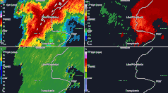
As the update was being issued, a strong supercell evolved near the Louisiana-Mississippi border. By 7:57 p.m. CDT, a strong velocity couplet formed at the base of the supercell, and at 8:04 p.m., as the storm approached the town of Rolling Fork, a tornado emergency was placed.[15] The storm then began producing the long-tracked and deadly high-end EF4 tornado that struck Rolling Fork, Midnight, and Silver City, inflicting catastrophic damage and causing over a dozen fatalities.[16][17] While the violent EF4 tornado was on the ground, Harry Weinman, a forecaster at the SPC, issued a special meso-gamma mesoscale discussion for the tornado.[18] In the discussion, the SPC stated that radar showed debris was being lofted at least 13,000 feet (4,000 m) into the air and that a vertical rotation of 70 knots (81 mph; 130 km/h) was also being detected. The SPC also indicated that this was likely an intense tornado, at least EF3, solely based on the Doppler radar data.[19][20] The discussion concluded by noting that the downstream atmospheric environment would allow the storm producing the violent EF4 tornado to persist for 30 to 60 minutes.[18]
Tornado summary
| Fatalities | Fatality location |
|---|---|
| 10 | Mobile home/Trailer home |
| 4 | Permanent home |
| 2 | Business |
| 1 | Vehicle |
Formation
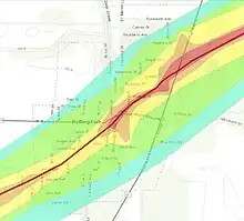
The tornado first touched down in Issaquena County, southeast of Mayersville, which is east of the Mississippi River. It tracked northeastward, causing minor tree damage near Grand Road, before crossing over the Steele Bayou Canal and into Sharkey County, producing EF0 to EF1 damage to trees, power poles, and some outbuildings. The tornado then rapidly grew in size and reached EF2 strength as it approached Rolling Fork from the southwest. Violent rotation of radar, paired with a debris signature, prompted the issuance of a tornado emergency; it would remain under this tag for most of its existence. Power poles and large trees were snapped, and as the tornado reached a small subdivision on Ending Bar Road, a house lost its roof and exterior walls and two residences west of that home lost significant portions of their roof covering.
Tracking closer towards Rolling Fork, the tornado directly moved through the Indian Bayou subdivision along Pinkins Road at EF4 intensity. Every residence in the subdivision was destroyed—some completely swept from their slabs. Most of the homes in the area were poorly constructed or were manufactured homes. Large hardwood trees near the residences were debarked, and some denuded, at EF4 intensity. As the tornado crossed MS 826, a large metal building was swept away, as well as a small brick structure. Most trees across the highway were also uprooted or turned to stubs. The tornado would also destroy or significantly damage numerous homes east of the highway before crossing into Rolling Fork.[21]
Rolling Fork
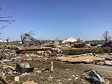
As the tornado entered the main neighborhoods of Rolling Fork, it weakened, but remained strong, producing widespread EF2-EF3 damage throughout much of the town's west subdivisions. Frame homes were leveled or swept from their foundations, approximately 30 manufactured homes were obliterated, and large amounts of structural debris was scattered throughout the community. Many other houses sustained major structural damage, with roofs completely removed and exterior walls destroyed, while the Sharkey Issaquena Hospital sustained damage to its exterior.[22][23] A couple was killed near 6th St by a large semi-truck that was lofted and slammed into their home. Several structures at an agriculture business were also flattened. The tornado again increased to EF4 intensity near the center of Rolling Fork at MS 14. A large brick duplex was leveled and partially swept from its foundation and two warehouses near the center of town were obliterated. The local library was destroyed; the Rolling Fork Police Department sustained roof loss and some collapse of exterior walls; and the fire station, post office, city hall, Rolling Fork Elementary School, South Delta High School, and a church were significantly damaged.[22][23]
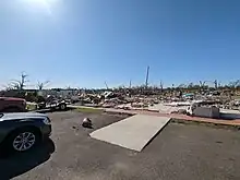
Multiple older brick buildings in downtown Rolling Fork also sustained major structural damage. Several other well-built businesses and structures were leveled, with only piles of debris remaining; one of the structures had multiple tractor-trailers thrown into it. One of the town's water towers was toppled when flying debris compromised its base, leaving a crater where it impacted the ground. Water towers are not an official damage indicator on the Enhanced Fujita scale; however, the National Weather Service rated the damage done to the tower EF4 with no estimated wind speed. Mechanical engineer Ethan Moriarty determined—assuming that the tower was made from one single piece of metal that was properly anchored and had not suffered environmental corrosion—that winds up to 229 miles per hour (369 km/h) would be needed to cause the observed damage to the water tower.[24] Some of the most violent damage occurred in the northeastern part of town, where a flower shop housed in a well-built brick building was leveled at high-end EF4 strength, with its concrete foundation slab partially swept clean of debris. The National Weather Service determined that winds up to 195 miles per hour (314 km/h) would have been needed to cause the damage done to the flower shop. Several nearby homes were also obliterated; large metal-framed buildings, including a Family Dollar store along US 61/MS 14, were flattened as well. Chuck's Dairy Bar had a pickup truck thrown into it and was destroyed, but several people survived at the location by taking shelter in the business's walk-in cooler, the only part of the building left intact after the tornado's passage. Many vehicles were also thrown through the air and mangled. Numerous large trees in and around Rolling Fork were denuded and debarked, and a few of them were stripped clean of all bark.[25][26]
Ground scouring and extreme forest damage
After exiting Rolling Fork, the tornado remained violent as it moved across several open fields, where severe ground scouring occurred and debris from the town was scattered long distances to the northeast. When it crossed Matthews Boulevard, several utility poles were snapped off at the base or pulled out of the ground, and some were left covered in up to 1–2 in (2.5–5.1 cm) of mud. A few of the missing power poles were never found, and damage in this area was rated EF2 to EF3. Southeast of Anguilla, the tornado inflicted EF4-strength damage again to hardwood trees, with most mangled or debarked.[23] A mobile home was swept away and obliterated with very little debris remaining, and a bus on the property was tossed into trees. Numerous additional wooden power poles were snapped, a semi-trailer was overturned, and a few homes at the edge of the damage path had minor damage. Aerial imagery of this area also revealed ground scouring and the presence of cycloidal marks in open fields. The tornado then moved into a densely forested area, causing large amounts of EF2 to EF3 tree damage.[23][22] It crossed MS 14 east of Anguilla at EF2 strength, destroying a small, older frame home, snapping many trees and power poles, and rolling a mobile home.[22][23]
Midnight
Maintaining EF2 strength, the tornado then crossed into Humphreys County and continued northeastward, where a home suffered partial destruction of its roof and garage. A truck inside the garage was overturned while another was moved, and a nearby shop building was destroyed, with its metal structural beams bent. The tornado then briefly strengthened to high-end EF3 strength as it leveled a small brick home along Seven Mile Road, and overturned a nearby grain loader. Another home had most of its roof removed and part of a wall collapsed, with vehicles blown out of its garage. Some metal buildings were damaged or destroyed. Grain bins were heavily damaged in this area as well; debris, including a grain cart, was scattered for hundreds of yards into a field. Passing through the small community of Midnight, the tornado produced EF2 damage: a home and a few barns were destroyed, trees and power poles were snapped, a sign was blown over, and a metal building and a small brick building sustained roof damage. The tornado then moved northeast along MS 149, causing EF2 to EF3 damage as it approached Silver City from the southwest. A mobile home was destroyed after being thrown 75 ft (23 m) into a nearby field, with only the porch being left behind. A portion of the roof was blown off a school, several homes suffered partial roof loss, and two metal buildings were destroyed, with large support beams bent and debris scattered across fields. Large areas of hardwood trees were snapped and uprooted, and multiple center pivot irrigation systems were flipped in this area as well.[23][22]
Silver City, weakening, and dissipation

The tornado then weakened some but continued causing significant damage as it moved into Silver City, where multiple apartment buildings suffered heavy roof damage, including some that had portions of their roofs removed and one that had its walls partially collapsed. Many homes throughout the town had extensive roof damage; some lost their roofs completely, and a few sustained collapse of one or more exterior walls. Four manufactured homes were destroyed in the center of town, a church sustained roof damage, a large number of old hardwood trees were snapped or uprooted, and power lines were downed. Damage in Silver City was rated EF1 to EF2 in intensity. The tornado then weakened further and moved northeastward into rural forested areas, downing trees and causing roof and window damage to a few homes to the southeast of Belzoni, with damage in this area being rated EF0 to EF1. It then moved into Holmes County, where more trees were snapped and uprooted at EF1 strength as the tornado approached and crossed US 49E north of Tchula. The tornado produced a final small area of significant damage, snapping or uprooting large tree trunks at EF2 intensity in the Morgan Brake National Wildlife Refuge. Beyond this point, the tornado weakened again and produced additional EF0 to EF1 damage as it overturned pivot irrigation systems, damaged trees, and flipped or destroyed grain bins. It dissipated after crossing Randle Road.
In total, the tornado traveled 59.4 miles (95.6 km), killing 17 people and injuring 165 others.[22][23][27][28][3] The tornado moved with an average forward speed of 50 miles per hour (80 km/h).[29]
Aftermath

Preliminary information from the National Weather Service in Jackson, Mississippi indicated that over 78% of the city of Rolling Fork and over 96% of Silver City sustained some level of damage from the tornado, with at least 300 homes sustaining damage in Rolling Fork.[22][30] Rolling Fork's funeral director and mayor, Eldridge Walker, said on March 27 that search-and-rescue efforts were "pretty close" to finished and authorities believed that everyone had been accounted for.[31][32] Following major damage to the Sharkey Issaquena Community Hospital and the Delta Health Center, both based in Rolling Fork, the University of Mississippi Medical Center partnered with state agencies to establish a temporary field hospital at the town's National Guard Armory.[33] The Mississippi Emergency Management Agency (MEMA) contracted with the Red Cross to provide survivors with meals and lodging in hotel rooms for up to six months.[34] By April 11, Mayor Walker said that 500 people—approximately a third of the town's population—remained displaced.[35] More than 200 remained displaced in mid-August.[36] To dispose of debris and waste from the tornado's damage, Sharkey County established a burn site on the town's outskirts. On April 10 alone, 260 truckloads of debris made the trip to the burn site.[35] Influencer and YouTuber Ryan Hall, Y'all raised $120,000 through social media to give generators out after the storm.[37]
The Mississippi Insurance Department stated that insured losses from the tornado were near $100 million (2023 USD), with uninsured losses likely even higher.[38]
Political response

Both state and national politicians responded to the devastation in Mississippi. On March 25, Governor of Mississippi Tate Reeves declared a state of emergency in Sharkey, Humphreys, Carroll, and Monroe counties.[39] Governor Reeves's request for a major disaster declaration was granted by President Joe Biden on March 26.[40] President Biden visited Rolling Fork on March 31 and announced that the federal government would fully cover the cost of the cleanup.[41] The Mississippi state legislature also later approved approximately $18.5 million in tornado relief funds.[28]
See also
References
- The National Oceanic and Atmospheric Administration‘s finalized damage survey by county:
- National Centers for Environmental Information (18 September 2023). "Mississippi Event Report: EF1 Tornado (Issaquena County)". Storm Event Database. National Oceanic and Atmospheric Administration. Archived from the original on 18 September 2023. Retrieved 18 September 2023.
- National Centers for Environmental Information (18 September 2023). "Mississippi Event Report: EF4 Tornado (Sharkey County)". Storm Event Database. National Oceanic and Atmospheric Administration. Archived from the original on 18 September 2023. Retrieved 18 September 2023.
- National Centers for Environmental Information (18 September 2023). "Mississippi Event Report: EF3 Tornado (Humphreys County)". Storm Event Database. National Oceanic and Atmospheric Administration. Archived from the original on 18 September 2023. Retrieved 18 September 2023.
- National Centers for Environmental Information (18 September 2023). "Mississippi Event Report: EF2 Tornado (Holmes County)". Storm Event Database. National Oceanic and Atmospheric Administration. Archived from the original on 18 September 2023. Retrieved 18 September 2023.
- National Weather Service in Jackson, Mississippi (22 September 2023). "The Intense Mississippi Tornadoes of March 24, 2023" (StoryMap). ArcGIS StoryMaps. National Oceanic and Atmospheric Administration. Archived from the original on 23 September 2023. Retrieved 23 September 2023.
- National Weather Service in Jackson, Mississippi (6 June 2023). "Rolling Fork-Silver City Tornado". Iowa Environmental Mesonet. National Oceanic and Atmospheric Administration. Archived from the original on 10 September 2023. Retrieved 10 September 2023.
- Jared Guyer. "Day 4–8 Severe Weather Outlook Issued on Mar 18, 2023". Archived from the original on March 25, 2023. Retrieved March 25, 2023.
- Matt Mosier (March 24, 2023). "Day 4–8 Severe Weather Outlook Issued on Mar 20, 2023". Storm Prediction Center. Archived from the original on March 20, 2023. Retrieved March 25, 2023.
- Evan Bentley (March 24, 2023). "Mar 23, 2023 0600 UTC Day 1 Convective Outlook". Storm Prediction Center. Archived from the original on March 25, 2023. Retrieved March 25, 2023.
- Matt Mosier (March 24, 2023). "Mar 23, 2023 0600 UTC Day 2 Convective Outlook". Storm Prediction Center. Archived from the original on March 22, 2023. Retrieved March 25, 2023.
- Matt Mosier (March 24, 2023). "Mar 23, 2023 0600 UTC Day 2 Convective Outlook". Storm Prediction Center. Archived from the original on March 25, 2023. Retrieved March 25, 2023.
- Evan Bentley; Harry Weinman (March 24, 2023). "Mar 24, 2023 0600 UTC Day 1 Convective Outlook". Storm Prediction Center. Archived from the original on March 25, 2023. Retrieved March 25, 2023.
- Harry Weinman; Rich Thompson (March 24, 2023). "Mesoscale Discussion 324". Storm Prediction Center. Archived from the original on March 26, 2022. Retrieved March 25, 2023.
- Thompson, Rich (March 24, 2023). "Tornado Watch 76". Storm Prediction Center. Archived from the original on March 26, 2023. Retrieved March 26, 2023.
- Weinman, Harry; Thompson, Rich (March 24, 2023). "Mesoscale Discussion 326". Storm Prediction Center. National Weather Service. Archived from the original on March 26, 2022. Retrieved March 25, 2023.
- Harry Weinman (March 24, 2023). "Mesoscale Discussion 328". Storm Prediction Center. Archived from the original on March 26, 2022. Retrieved March 25, 2023.
- Smith (March 24, 2023). "Mar 25, 2023 0100 UTC Day 1 Convective Outlook". Storm Prediction Center. National Weather Service. Archived from the original on April 14, 2023. Retrieved July 12, 2023.
- "IEM :: Valid Time Event Code (VTEC) App". mesonet.agron.iastate.edu. Retrieved 2023-03-24.
- Harry Weinman (March 24, 2023). "Mesoscale Discussion 329". Storm Prediction Center. Archived from the original on March 25, 2023. Retrieved March 25, 2023.
- Brynn Kerr (March 24, 2023). "Mesoscale Discussion 330". Storm Prediction Center. Archived from the original on March 26, 2022. Retrieved March 25, 2023.
- Weinman, Harry (March 24, 2023). "Mesoscale Discussion 0329". Storm Prediction Center. National Weather Service. Archived from the original on March 25, 2023. Retrieved July 12, 2023.
- "Strong Tornado Causes Major Damage In Mississippi". The Weather Channel. Retrieved 12 July 2023.
- "Storm chasers reporting two tornadoes hit MS communities". Daily Kos. Retrieved 12 July 2023.
- Williams, Angela (2023-03-28). "NWS describes damage left in Mississippi by EF4 tornado". WAPT. Retrieved 2023-07-14.
- "Damage Assessment Toolkit". National Oceanic and Atmospheric Administration. Archived from the original on April 23, 2020. Retrieved March 25, 2023.
- National Weather Service in Jackson, Mississippi (March 27, 2023). NWS Damage Survey for March 24 tornado event (Report). Iowa Environmental Mesonet. Archived from the original on March 28, 2023. Retrieved March 28, 2023.
- Ethan Moriarty (7 April 2023). "DAMAGE ANALYSIS: Rolling Fork, MS EF4 Tornado". YouTube. @junefirst. Retrieved 11 July 2023.
- McCarthy, Kelly (27 March 2023). "Restaurant owner describes seeing the sky as she saved her staff from tornado". ABC News. Archived from the original on March 27, 2023. Retrieved 28 March 2023.
- "EF4 tornado devastates Mississippi city: What to know about the EF scale". MSN. Archived from the original on March 28, 2023. Retrieved 28 March 2023.
- Will McDuffie (March 24, 2023). "7 dead in 'destructive' Mississippi tornado, official says". ABC News. Archived from the original on March 25, 2023. Retrieved March 25, 2023.
- "Mississippi death toll from March tornado climbs to 22". Associated Press. May 4, 2023. Archived from the original on May 5, 2023. Retrieved May 10, 2023.
- "Speed Distance Time Calculator". Calculator Soup. Retrieved 11 July 2023.
- "Picking Up the Pieces: Rolling Fork couple reflect on tornado aftermath". WLOX. April 2023. Retrieved 11 July 2023.
- Beveridge, Lici (March 23, 2023). "Rolling Fork mayor comforts town destroyed by a tornado in a dual role as funeral director". Clarion Ledger. Retrieved March 28, 2023.
- Arancio, Victoria; Gewecke, Kenton; Hutchinson, Bill (March 27, 2023). "South reels from deadly tornado outbreak; 2-year-old among the 22 dead in Mississippi". WABC-TV. Archived from the original on March 27, 2023. Retrieved March 28, 2023.
- DiNatale, Sara; Royals, Kate (March 29, 2023). "Field hospital to open in Rolling Fork after tornado left town's health care facilities in shambles". Mississippi Today. Archived from the original on April 13, 2023. Retrieved April 13, 2023.
- Ball, Biancca (April 11, 2023). "MEMA, Red Cross help lodge Mississippi tornado survivors". WJTV. Archived from the original on April 12, 2023. Retrieved April 13, 2023.
- Simmons, Scott (April 11, 2023). "Mayor says 1/3 of Rolling Fork population displaced by tornadoes". WAPT. Archived from the original on April 12, 2023. Retrieved April 13, 2023.
- Harrison, Heather (September 1, 2023). "Rolling Fork Residents Still Waiting on Temporary Housing Five Months After Tornado". Mississippi Free Press. Archived from the original on September 14, 2023. Retrieved September 14, 2023.
- 'Our hearts are breaking' | Red Cross and others continue to aid Mississippi tornado victims, LocalMemphis, March 27, 2023. Retrieved April 17, 2023
- Goldberg, Michael (April 18, 2023). "Insurance losses from Mississippi tornado nearing $100M". Associated Press. Archived from the original on July 2, 2023. Retrieved July 12, 2023.
- "Gov. Reeves issues the State of Emergency following deadly storms". WLBT. March 25, 2023. Archived from the original on March 25, 2023. Retrieved March 25, 2023.
- Lynch, Adam; McCarley, Ginny Cooper; Gurley, Lauren Kaori; Brasch, Ben; Shammas, Brittany (March 26, 2023). "For some Rolling Fork residents, recovery from Mississippi tornado is uncertain". The Washington Post. Archived from the original on March 27, 2023. Retrieved March 27, 2023.
- Fossum, Sam (31 March 2023). "Biden to announce that federal government will fully cover cost of cleanup following deadly storms | CNN Politics". CNN. Retrieved 31 March 2023.