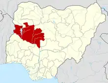
Agaie
Agaie is a Local Government Area in Niger State, Nigeria. Its headquarters are in the town of Agaie on the A124 highway.
Agaie
Garin Mallam Babba Farin Kasa | |
|---|---|
LGA and town | |
 Agaie Location in Nigeria | |
| Coordinates: 9°01′N 6°19′E | |
| Country | |
| State | Niger State |
| Government | |
| • Local Government Chairman and the Head of the Local Government Council | Captain. Hassan Baro |
| • Emir | Alhaji Yusuf Nuhu |
| Area | |
| • Total | 1,903 km2 (735 sq mi) |
| Population (2006 census) | |
| • Total | 132,907 |
| Time zone | UTC+1 (WAT) |
| 3-digit postal code prefix | 911 |
| ISO 3166 code | NG.NI.AA |
It has an area of 1,903 km2 and a population of 132,907 at the 2006 census.
The postal code of the area is 911.[1]
History
Agaie was a 19th-century state in present-day Nigeria covering roughly the same land of the present LGA. It was originally inhabited by Nupe people, but became an emirate and part of the Fulani Empire in 1822, after Fulani mercenaries intervened in the Nupe civil wars. In the early 20th century, the land became a part of the British Empire.The Etsu nupe Agaie is Alhaji Yusuf Nuhu [2]
Climate
In Agaie, the wet season is oppressive and overcast, the dry season is humid and partly cloudy, and it is hot year round. Over the course of the year, the temperature typically varies from 63°F to 95°F and is rarely below 56°F or above 101°F.[3][4][5]
The hot season lasts for 2.8 months, from January 29 to April 21, with an average daily high temperature of above 9°F. The hottest month of the year in Agaie is April, with an average high temperature of 93°F and low temperature of 77°F.[3]
A daily maximum temperature below 86°F is typical during the 3.2 months of the cool season, which runs from June 28 to October 3. December, with average lows of 64°F and highs of 91°F, is the coldest month of the year in Agaie.[4]
Cloud
Agaie's annual average for the proportion of the sky that is covered in clouds varies significantly by season.[6][7][3]
Around November 6 marks the start of Agaie's clearer season, which lasts for 3.5 months and ends around February 21.[6][7][4]
In Agaie, December is the clearest month of the year, with the sky remaining clear, mostly clear, or partly overcast 55% of the time.[6][3]
Beginning at February 21 and lasting for 8.5 months, the cloudier period of the year ends around November 6.[6][3]
May is the cloudiest month of the year in Agaie, with the sky being overcast or mostly cloudy 82% of the time on average during this month.[7][3][6]
References
- "Post Offices- with map of LGA". NIPOST. Archived from the original on 7 October 2009. Retrieved 2009-10-20.
- "The AGAIE EMIRATE". Nuhu Lafarma (Education) Foundation. Archived from the original on 2011-04-16. Retrieved 2010-09-01.
- "Agaie Climate, Weather By Month, Average Temperature (Nigeria) - Weather Spark". weatherspark.com. Retrieved 2023-07-10.
- Atlas, Weather. "Agaie, Nigeria - Yearly & Monthly weather forecast". Weather Atlas. Retrieved 2023-07-10.
- "Simulated historical climate & weather data for Agaie". meteoblue. Retrieved 2023-07-10.
- "Agaie, Nigeria Weather Conditions | Weather Underground". www.wunderground.com. Retrieved 2023-07-10.
- "Agaie, Niger, Nigeria 10-Day Weather Forecast - The Weather Channel | Weather.com". The Weather Channel. Retrieved 2023-07-10.
