Hamat Gader
Hamat Gader (Hebrew: חַמַּת גָּדֵר; Imperial Aramaic: חמתא דגדר, hammata degader; Ancient Greek: Ἑμμαθά, Emmatha or ῎Αμαθα, Amatha;[1] Arabic: الحمة السورية al-Hamma al-Souriya, meaning "the Syrian Hamma") is a hot springs site in the Yarmouk River valley, used since the classical antiquity. It is located in an area under Israeli control, in what was a demilitarized zone between Israel and Syria from 1949 to 1967.[2] The site is next to the Jordanian border, and about 10 kilometres (6.2 mi) from the tripoint of Israel, Jordan and Syria. It is set on several mineral springs with temperatures up to 50 °C.


Etymology
The ancient Hebrew name, Hammat Gader or Hammath Gader, means hot springs of Gader,[3] also translated as Hammath-by-Gadara.[4] The ruins of the ancient city of Gadara stand south of Hammat Gader,[3] on the plateau edge above the springs, in modern Umm Qais.
The Arabic name Al-Hammeh or El-Hamma dates back to the medieval period[3] and also relates to "hot springs". The name of the tell located near the site, Tell Bani,[4][5] is a corruption of the Latin word meaning "baths".
History
Roman, Byzantine and Umayyad periods
Hamat Gader was already a widely known health and recreation site in Roman times.[6] It is mentioned in Strabo,[7] Origen[8] and Eunapius,[9] as well as the Rabbinic literature of the first centuries CE.
Construction of the bath complex began in the 2nd century by the 10th Roman Legion, which was garrisoned in the city of Gadara. Two distinct construction periods are evident at the site: The Roman-Byzantine Period, during which most of the bath complex was built, and the Muslim period, during which major changes were made to the existing structures.[10]
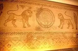
The site includes a Roman theatre, which was built in the 3rd century CE and contained 2,000 seats. A large synagogue was built in the 5th century CE.[11] The empress Aelia Eudocia composed a poem praising the qualities of the multiple springs which was inscribed so that visitors could see it as they went into the pool.
Some of the buildings including the famous thermae were damaged by an earthquake and restored in 663 by the first Umayyad caliph Mu'awiyah who ruled from Damascus.[12] A century later the 749 Galilee earthquake hit. Eventually, in the 9th century, the baths were abandoned and a thick layer of silt covered the ruins.
Mandate period
The border between the Mandatory Palestine and the French Mandate for Syria and the Lebanon was drawn in 1923, and Al-Hamma was included in Palestine.[13]
Before 1949, the Palestinian Arab village Al-Hamma was located at this site. At the time of the 1931 census, it had 46 occupied houses and a population of 170 Muslims, 1 Jew and 1 Christian.[14]
Syrian control

After the 1948 Arab–Israeli War, according to the armistice agreements of 1949 Between Israel and Syria, it was determined that the area would be included in the demilitarized zone (DMZ) between Israel and Syria. The villagers and their property were formally protected by Article V of the Israeli-Syrian agreement of 20 July that year.[15][16] However, Israel thought the Arab villagers could pose a security threat, and Israeli settlers and settlement agencies coveted the land. Israel therefore wanted the Palestinian inhabitants, a total of 2,200 people, moved to Syria.[15]
On April 4, 1951, a two-vehicle military patrol set out for Hamat Gader in order to assert Israeli sovereignty over the site, over the objections from the Northern Command that Syria was likely to attack it.[17] Since military forces were not permitted in the DMZ, members of the patrol were disguised as policemen.[17] As predicted, the Syrians attacked the patrol and seven Israeli soldiers were killed.[17] In retaliation, Israel bombed the Syrian police station at al Hamma and another Syrian position, killing two women, and demolished the empty houses in Kirad al-Ghannama, Kirad al-Baqqara, Al-Samra and Nuqeib in order to render the DMZ "clear of Arabs".[17]
Israeli control
Israeli control over Hamat Gader was secured during the Six-Day War in 1967, when the Israeli army occupied the surrounding Golan Heights, allowing free access to Hamat Gader for Israelis. Since then, it has been under Israeli control and has been developed as a tourist attraction, health resort and an alligator and exotic bird reserve. The health resort opened in 1977.[18]
Today, Hamat Gader also includes a crocodilian farm with crocodiles, alligators and even caimans and gavials. It has about 200 crocodilians and it is the largest crocodile farm in the Middle East.
Tourist site
The Hamat Gader tourist site is centered around thermal baths and a crocodile farm. The water of the thermal baths contains sulfur at a concentration of 4.7%, which may have a therapeutic effect on skin diseases, asthma, rheumatism and wrist pain, as well as renew skin cells.
Further reading
- E.L. Sukenik, The Ancient Synagogue of el-Hammeh, Journal of the Palestine Oriental Society, 1935. pp. 101–ff.
References
- Brown, J., E. Meyers, R. Talbert, T. Elliott, S. Gillies (30 January 2019). "Places: 678131 (Emmatha)". Pleiades. Retrieved August 8, 2014.
{{cite web}}: CS1 maint: multiple names: authors list (link) - Israel to build dam on disputed land claimed by Syria New York Times, 26 August 1997
- Negev, Avraham; Gibson, Shimon, eds. (2001). Hamath Gader. pp. 2015–2016. ISBN 0-8264-1316-1. Retrieved 27 January 2022.
{{cite book}}:|work=ignored (help) (Snippet view). - May, Herbert Gordon (February 1944). "Synagogues in Palestine". The Biblical Archaeologist. The University of Chicago Press for the American Schools of Oriental Research (BASOR). 7 (1): 1-20 [see p. 15]. doi:10.2307/3209112. JSTOR 3209112. S2CID 194966510. Retrieved 26 January 2022.
- Levin, Gabriel (2013). The Dune's Twisted Edge: Journeys in the Levant. University of Chicago Press. p. 182. ISBN 978-0226923673. Retrieved 26 January 2022. Levin is quoting Eliezer Sukenik.
- Hirschfeld, Yizhar (1987). "The History and Town-Plan of Ancient Ḥammat Gādẹ̄r". Zeitschrift des Deutschen Palästina-Vereins. 103: 101–116. JSTOR 27931308.
- Geog. XVI, 45.
- Commentary on St. John, VI, 41, 210
- Vit. Soph. 368-370. Ma'oz, Zvi Uri (1997). "Hammath-Gader". The Oxford Encyclopedia of Archaeology in the Near East. p. 468. ISBN 0195112156.
- Hamat Gader Information Site Archived 2006-02-12 at archive.today
- Eleazar Sukenik, "The ancient synagogue at Hamat Gader" (in Qobes, Jewish Palestine Exploration Society, 1934), pp. 41-61
- Hirschfeld, Yizhar; Solar, Giora (1981). "The Roman Thermae at Ḥammat Gader: Preliminary Report of Three Seasons of Excavations". Israel Exploration Journal. 31 (3/4): 197–219. ISSN 0021-2059. JSTOR 27925800.
- "The Line of June 4, 1967", Frederic C. Hof, Jewish Virtual Library
- Mills, E., ed. (1932). Census of Palestine 1931. Population of Villages, Towns and Administrative Areas. Jerusalem: Government of Palestine. p. 82.
- Morris, Benny (2004). The Birth of the Palestinian Refugee Problem Revisited. Cambridge University Press. p. 513. ISBN 978-0-521-00967-6.
- UN Doc S/1353 Archived 2011-07-26 at the Wayback Machine Syria Israel Armistice Agreement of 20 July 1949
- Benny Morris (1993). Israel's Border Wars, 1949–1956. Oxford University Press. pp. 378–279.
- Hamat Gader in the 20th Century
External links
- Photos of the Hammat Gader baths at the Manar al-Athar photo archive