Alofi
Alofi is the capital of the island nation of Niue. With a population of 597 in 2017,[6] Alofi has the distinction of being the second-smallest capital city of a sovereign state by population (after Ngerulmud, capital of Palau). It consists of two villages: Alofi North and Alofi South. They collectively serve as the capital, but of the two, Alofi South hosts more government buildings, as many were moved to the southern part after Cyclone Heta.
Alofi | |
|---|---|
 A street in Alofi | |
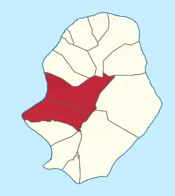 Alofi council within Niue | |
 Administrative map of Niue showing all the villages. Alofi is on the western side of the island | |
| Coordinates: 19°03′15″S 169°55′10″W | |
| Country | New Zealand |
| Constituent country | Niue |
| Tribal Area | Tafiti |
| Village | Alofi North and Alofi South |
| Government | |
| • Assemblyman of Alofi North | Vaiga Tukuitoga[1] |
| • Assemblyman of Alofi South | Dalton Tagelagi[2] |
| Area | |
| • Area of both Alofi North and Alofi South | 46.48 km2 (17.95 sq mi) |
| Elevation | 21 m (69 ft) |
| Population (2017)[4] | |
| • Total | 597 |
| • Density | 12.5/km2 (32.46/sq mi) |
| • Alofi North | 147 |
| • Alofi South | 434 |
| Resident Population | |
| • Visitors (Alofi North) | 6,214 |
| • Visitor (Alofi South) | 6,214 |
| Time zone | UTC-11 (UTC-11) |
| Area code | +683 |
History
In January 2004, Niue was hit by the fierce tropical storm Cyclone Heta, which killed two people and did extensive damage to the entire island. Many of Alofi's buildings were destroyed, including the hospital. Government buildings were shifted to a less exposed site 3 km (≈ 2 mi) inland from the west coast,[7] named Fonuakula, after the storm.[8] This site is within the village boundaries of Alofi South.
Geography
Overview
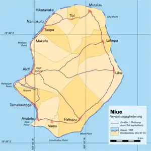
It is located at the centre of Alofi Bay on the west coast of the island, close to the only break in the coral reef that surrounds Niue. The bay stretches for 30% of the island's length (about seven kilometres) from Halagigie Point in the south to Makapu Point in the north.
The council's territory borders with Avatele, Hakupu, Lakepa, Liku, Makefu, Mutalau, Tamakautoga and Tuapa.[9]
Climate
| Alofi | ||||||||||||||||||||||||||||||||||||||||||||||||||||||||||||
|---|---|---|---|---|---|---|---|---|---|---|---|---|---|---|---|---|---|---|---|---|---|---|---|---|---|---|---|---|---|---|---|---|---|---|---|---|---|---|---|---|---|---|---|---|---|---|---|---|---|---|---|---|---|---|---|---|---|---|---|---|
| Climate chart (explanation) | ||||||||||||||||||||||||||||||||||||||||||||||||||||||||||||
| ||||||||||||||||||||||||||||||||||||||||||||||||||||||||||||
| ||||||||||||||||||||||||||||||||||||||||||||||||||||||||||||
Alofi features a tropical rainforest climate under the Köppen climate classification, with no discernible dry season. The city has a noticeably drier stretch from June through September. However, all of these months average more than 60 mm (2.4 in) of rain, the limit for a dry season month. Average temperatures vary slightly throughout the course of the year in Alofi hovering at around 27 °C (81 °F), during the warmest month (February) and at around 23 °C (73 °F) during the coolest months (July and August).
| Climate data for Alofi | |||||||||||||
|---|---|---|---|---|---|---|---|---|---|---|---|---|---|
| Month | Jan | Feb | Mar | Apr | May | Jun | Jul | Aug | Sep | Oct | Nov | Dec | Year |
| Record high °C (°F) | 38 (100) |
38 (100) |
32 (90) |
36 (97) |
30 (86) |
32 (90) |
35 (95) |
37 (99) |
36 (97) |
31 (88) |
37 (99) |
36 (97) |
38 (100) |
| Average high °C (°F) | 28 (82) |
29 (84) |
28 (82) |
27 (81) |
26 (79) |
26 (79) |
25 (77) |
25 (77) |
26 (79) |
26 (79) |
27 (81) |
28 (82) |
27 (81) |
| Daily mean °C (°F) | 26 (79) |
27 (81) |
26 (79) |
25 (77) |
25 (77) |
23 (73) |
22 (72) |
23 (73) |
23 (73) |
24 (75) |
25 (77) |
26 (79) |
25 (77) |
| Average low °C (°F) | 23 (73) |
24 (75) |
24 (75) |
23 (73) |
22 (72) |
21 (70) |
20 (68) |
20 (68) |
21 (70) |
21 (70) |
22 (72) |
23 (73) |
22 (72) |
| Record low °C (°F) | 20 (68) |
20 (68) |
20 (68) |
14 (57) |
15 (59) |
13 (55) |
11 (52) |
11 (52) |
15 (59) |
15 (59) |
11 (52) |
17 (63) |
11 (52) |
| Average precipitation mm (inches) | 261.6 (10.30) |
253.6 (9.98) |
305.6 (12.03) |
202.6 (7.98) |
138.2 (5.44) |
88.9 (3.50) |
96.4 (3.80) |
105.8 (4.17) |
102.4 (4.03) |
123.8 (4.87) |
145.5 (5.73) |
196.2 (7.72) |
2,018.4 (79.46) |
| Source: Weatherbase[10] | |||||||||||||
Transport
The town is serviced by Niue International Airport, and there are numerous roads, both paved and dirt, that crisscross the town.[11]
The island's main seaport is Sir Roberts Wharf. It is located at 19°03′10″S 169°55′15″W, close to the centre of Alofi, within 200 metres of the capital's post office and just to the north of the Chamber of Commerce building. It is a small wharf, capable – due to the island's topography — of only handling smaller flat-bottomed boats. Larger cargo vessels and fishing boats moor near the reef, and barges are used to offload cargo. Major strengthening, extension work, and renovations to the wharf were commissioned in 2020, after cyclone damage earlier in the year.[12]
Personalities
- Dalton Tagelagi (b. 1968), politician
- Sam Pata Emani Tagelagi (1935–2011), politician
See also
References
Notes
- New Zealand Ministry of Foreign Affairs and Trade
- Government of Niue
- Weatherbase
- "Niue Household and Population Census 2017" (PDF). niue.prism.spc.int. Niue Statistics Office. Retrieved 5 May 2020.
- SPC 2008, p.5.
- "Niue Household and Population Census 2017" (PDF). niue.prism.spc.int. Niue Statistics Office. Retrieved 5 May 2020.
- "Alofi | Encyclopedia.com". www.encyclopedia.com. Retrieved 3 September 2023.
- East-West Center
- 1558549 Alofi on OpenStreetMap
- "Weatherbase: Historical Weather for Alofi, Niue". Weatherbase. Retrieved 3 August 2009.
- "Niue International Airport". Archived from the original on 3 March 2016. Retrieved 26 October 2012.
- Pavihi, Esther. "A much stronger and bigger Sir Robert's Wharf officially commissioned". Television Niue. Retrieved 20 April 2022.
Sources
- East-West Center (20 January 2009). "Niue recovery at $23 million, Alofi to be relocated". East-West Center. East-West Center. Retrieved 3 August 2009.
- NZ Ministry of Foreign Affairs and Trade (22 June 2009). "Niue – Country Information Paper – NZ Ministry of Foreign Affairs and Trade". NZ Ministry of Foreign Affairs and Trade. Retrieved 3 August 2009.
- Siosikefu, Margaret Hagen; Haberkorn, Gerald (2008). Niue population profile based on 2006 census of population and housing: a guide for planners and policy-makers (PDF). Nouméa, New Caledonia: Secretariat of the Pacific Community. pp. 4–5. ISBN 978-982-00-0235-7. AACR2 304.609 9626. Archived (PDF) from the original on 13 November 2009. Retrieved 3 August 2009.
- "Weatherbase: Historical Weather for Alofi, Niue". Weatherbase. 2009. Retrieved 3 August 2009.