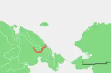
Amguema (river)
The Amguema (Russian: Амгуэ́ма, Chukot: Оʼмваам, O'mvaam;[1] in its upper course Вульвывее́м, Vulvyveyem[2]) is a river in Chukotka Autonomous Okrug, Russia.[3] It is 498 kilometres (309 mi) long, and has a drainage basin of 28,100 square kilometres (10,800 sq mi).[4]
| Amguema | |
|---|---|
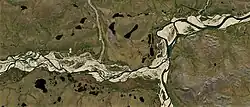 Sentinel-2 image of the confluence of the Ekityki (left) and the Amguema | |
 | |
| Native name | |
| Location | |
| Country | Russia |
| Physical characteristics | |
| Source | |
| • coordinates | 68°49′N 177°24′E |
| Mouth | Chukchi Sea |
• coordinates | 68.2533°N 177.4239°W |
| Length | 498 km (309 mi) |
| Basin size | 28,100 km2 (10,800 sq mi) |
| Discharge | |
| • average | 285 m3/s (10,100 cu ft/s) |
Upriver there is the small town of Amguema, where about 600 mostly Chukchi people live.[5]
Geography
The Amguema flows roughly from SW to NE across the Chukotka Mountains. It belongs to the Amguema basin. It empties into the Chukchi Sea between Cape Schmidt and Cape Vankarem.[6] The 154 km (96 mi) long Ekityki on the left is the main tributary of the Amguema.[4]
See also
References
- Russia. Topographic map Q-60-XI,XII
- Dictionary of names of hydrographic objects of Russia and other countries - members of the CIS Archived 2016-03-06 at the Wayback Machine (1999), p. 22
- Geographic Location
- "Река Амгуема (Омваам, в верховье Вульвывеем) in the State Water Register of Russia". textual.ru (in Russian).
- Amguema Town
- Chukotskoye Nagorye Archived 2019-06-30 at the Wayback Machine / Great Russian Encyclopedia; in 35 vol.] / Ch. ed. Yu.S. Osipov . - M .: Great Russian Encyclopedia, 2004—2017.
This article is issued from Wikipedia. The text is licensed under Creative Commons - Attribution - Sharealike. Additional terms may apply for the media files.