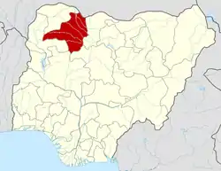
Anka, Nigeria
Anka is a Local Government Area in Zamfara State, Nigeria. Its headquarters is in the town of Anka at 12°06′30″N 5°56′00″E.
Anka | |
|---|---|
LGA and town | |
 Anka Location in Nigeria | |
| Coordinates: 11°59′N 6°02′E | |
| Country | |
| State | Zamfara State |
| Area | |
| • Total | 2,746 km2 (1,060 sq mi) |
| Population (2006 census) | |
| • Total | 142,280 |
| Time zone | UTC+1 (WAT) |
| 3-digit postal code prefix | 890 |
| ISO 3166 code | NG.ZA.AN |
It has an area of 2,746 km2 and a population of 142,280 at the 2006 census.
Anka Local Government Area of Zamfara is situated in the town of Anka as the chamber region covers different networks of Dan Galadima, Bagega, Waramu, Wuya, Yar'sabaya, Magaji, Sabon-Birni, Matseri and Barayar-Zaki.[1]
Anka local government region is one of the local government regions in Zamfara state Nigeria. It has its regulatory central command situated in Anka town. It is in the western part of the state of Zamfara. It is limited towards the north by Bakula and Talata Mafara nearby government regions, towards the east by Maru neighborhood government region, towards the south likewise by Maru neighborhood government region and towards the west by Bukkuyum neighborhood government region and Sokoto state.[1]
The postal code of the area is 890.[2]
Climate
In Anka, the dry season is oppressively hot and partially cloudy, while the wet season is oppressively hot and predominantly cloudy. The average annual temperature ranges from 59 to 103 degrees Fahrenheit, rarely falling below 54 or rising over 107.[3][4]
From March to May is the hot season, which lasts for two months and has an average daily high temperature of over 99 °F. In Anka, April is the hottest month of the year, with an average high of 102°F and low of 76°F.[5]
From July 7 to October 2, the cold season, which has an average daily high temperature below 89°F, lasts for 2.8 months. With an average low of 60°F and high of 92°F, January is the coldest month of the year in Anka.[6]
Economy
Anka local government area is well-known for growing a variety of crops, including grains and groundnuts. The region is also rich in minerals, including gold and lead, and mining activities play a significant role in the local economy.[7]
Anka local government area Chairman
The Executive Chairman of Anka Local Government Council is Alh Ahmed Balarabe Anka.[1]
Primary school enrolment In Anka
Anka local government area has a total Primary school enrolment of seventeen thousand seven hundred and twenty six (17,726). Which have been concluded by combining the Total number of males and females Students in the all local government area.
- Male = fifteen thousand one hundred and seventy two. (15,172)
- Female = two thousand five hundred and fifty four. (2,554)
By combining the numbers of males and females students, it gives an overall total of seventeen thousand seven hundred and twenty six (17726). This enrolment took place in the year between 1993 to 1999.[8]
Total number of ward in Anka local government area
Anka local government area of Zamfara state has a total number of 10 wards. These include
- Bagega
- Barayar zaki
- Dan Galadima
- Galadima
- Magaji
- Masteri
- Sabon birini
- Waramu
- Wuya
- Yar'sabaya[9]
Districts Under Anka LGA Includes
- Dan Galadima
- Bagega
- Waramu
- Wuya
- Yar'sabaya
- Magaji
- Sabon-Birni
- Matseri
- Barayar-Zaki[1]
Climate
The climate has a blistering, cloudy dry season with temperatures ranging from 59°F to 103°F, as well as a hot, oppressive rainy season with predominantly cloudy skies.[10][11]
References
- "Anka Local Government Area". www.finelib.com. Retrieved 2023-09-18.
- "Post Offices- with map of LGA". NIPOST. Archived from the original on 7 October 2009. Retrieved 2009-10-20.
- "Anka Climate, Weather By Month, Average Temperature (Nigeria) - Weather Spark". weatherspark.com. Retrieved 2023-09-29.
- "Anka, Zamfara, NG Climate Zone, Monthly Averages, Historical Weather Data". weatherandclimate.com. Retrieved 2023-09-29.
- "Simulated historical climate & weather data for Anka". meteoblue. Retrieved 2023-09-29.
- "Anka weather forecast for today". justweather.org. Retrieved 2023-09-29.
- "Anka Local Government Area". www.manpower.com.ng. Retrieved 2023-10-25.
- A. B, Mamman (1993). "Nigeria: a people united, a future assured, volume 2". Nigeria: a people united, a future assured, volume 2. 2: 320.
- A. B, Mamman (1993). "Nigeria: a people united, a future assured, volume 2". Nigeria: a people united, a future assured, volume 2. 2 (2) – via Rahamatu A Haliru.
- "Anka Climate, Weather By Month, Average Temperature (Nigeria) - Weather Spark". weatherspark.com. Retrieved 2023-09-01.
- "Anka, Zamfara, Nigeria - City, Town and Village of the world". en.db-city.com. Retrieved 2023-09-01.
